

Our planet is a canvas of dynamic forces, constantly reshaped by hidden processes that often unfold over millennia. Among the most powerful and enduring of these forces is the relentless work of ice. Glacial geology is the fascinating scientific discipline that explores how glaciers form, move, and profoundly alter the Earth’s surface, leaving behind distinctive landscapes that tell tales of ancient cold climates and immense power.
💡 Key Takeaways
- Glaciers are powerful agents of erosion and deposition, creating distinctive landforms.
- Key glacial features include U-shaped valleys, moraines, drumlins, and erratics.
- Studying glacial geology provides insights into Earth’s past climates and ice ages.
- Modern glaciers continue to shape landscapes, though their retreat poses new challenges.
“Glaciers are not just frozen rivers; they are dynamic architects of our planet’s surface, constantly rewriting geological history through their immense power and subtle shifts, offering vital clues about Earth’s climatic pulse.”
— Marcus Sterling, Geophysical Explorer & Climate Dynamics Analyst
From towering mountain ranges carved into dramatic spires to vast plains smoothed by millennia of ice movement, the fingerprints of glacial activity are etched across continents. Understanding these processes is not just about appreciating geological history; it’s crucial for comprehending climate change, managing water resources, and even predicting natural hazards. This comprehensive guide will take you on a journey through the icy mechanisms that shape our world, revealing the intricate dance between ice and rock.
In This Article
- — 💡 Key Takeaways
- → The Unseen Power of Ice: Understanding Glaciers
- — ❄️ What is a Glacier?
- — 🚶 How Glaciers Move
- → Mechanisms of Glacial Erosion
- — ⛏️ Plucking (Quarrying)
- — 📐 Abrasion
- — 💧 Meltwater Erosion
- → Iconic Glacial Landforms: Sculpted by Ice
- — ⛰️ Erosional Landforms
- — 🪨 Depositional Landforms
- → The Legacy of Ice Ages: A Global Impact
- — 🌍 Major Glacial Periods
- — 🔍 Reconstructing Past Climates
- → Modern Glacial Dynamics and Climate Change
- — 📉 Retreating Glaciers: A Telling Sign
- — 🌊 Implications for Sea Level and Ecosystems
- → Studying Glacial Geology: Tools and Techniques
- — 🔬 Fieldwork and Remote Sensing
- — 📊 Glacial Models and Projections
- → Conclusion
The Unseen Power of Ice: Understanding Glaciers
Glaciers are not merely static bodies of ice; they are dynamic rivers of frozen water, slowly but powerfully flowing under their own immense weight. Their presence and movement are fundamental to understanding the landscapes they create.
❄️ What is a Glacier?
A glacier is a persistent body of dense ice that is constantly moving under its own weight; it forms where the accumulation of snow exceeds its ablation (melting and sublimation) over many years. This compacted snow transforms into ice through a process called firnification.
- ✅ Alpine Glaciers: Found in mountainous regions, these glaciers flow down valleys, often creating dramatic U-shaped troughs.
- ✅ Continental Glaciers (Ice Sheets): Vast, dome-shaped sheets of ice that cover entire landmasses, like those in Greenland and Antarctica. These are remnants of the great ice ages that once enveloped much of the Northern Hemisphere.
🚶 How Glaciers Move
Despite their solid appearance, glaciers are constantly in motion, albeit often imperceptibly slow. This movement is primarily due to two mechanisms:
- ➡️ Internal Deformation (Plastic Flow): Under immense pressure, ice crystals within the glacier deform and slide past one another. This allows the glacier to flow like a very viscous fluid.
- ➡️ Basal Slip: Where the base of the glacier is warm enough, a thin layer of meltwater can form between the ice and the bedrock. This water acts as a lubricant, allowing the entire glacier to slide over the underlying terrain.
Mechanisms of Glacial Erosion
The true power of glaciers lies in their ability to erode, transport, and deposit vast quantities of rock and sediment. This process dramatically reshapes the Earth’s surface.
⛏️ Plucking (Quarrying)
Plucking occurs when meltwater from the base of a glacier seeps into cracks and fissures in the bedrock. As the water freezes, it expands, widening the cracks and dislodging blocks of rock. These rock fragments then become incorporated into the base of the glacier, ready to act as abrasive tools.
📐 Abrasion
Once rocks are embedded in the ice, the glacier uses them as sandpaper against the underlying bedrock. This process, known as abrasion, grinds down the rock, creating several distinctive features:

- 💡 Glacial Striations: Long, parallel scratches and grooves etched into the bedrock, indicating the direction of ice flow.
- 💡 Rock Flour: Finely ground rock particles, often giving meltwater a distinctive milky or turquoise appearance.
- 💡 Polished Surfaces: Smooth, polished rock surfaces where the glacier has abraded the rock over long periods.
💧 Meltwater Erosion
While the ice itself is the primary sculptor, the meltwater produced by glaciers also plays a significant role. Subglacial streams can carve tunnels and channels beneath the ice, transporting sediment and contributing to the erosional and depositional processes.
Iconic Glacial Landforms: Sculpted by Ice
The most striking evidence of glacial activity comes in the form of the unique glacial landforms they create. These features are broadly categorized as either erosional (carved by ice) or depositional (material left behind by ice).
⛰️ Erosional Landforms
These features are a testament to the powerful, destructive capability of moving ice.
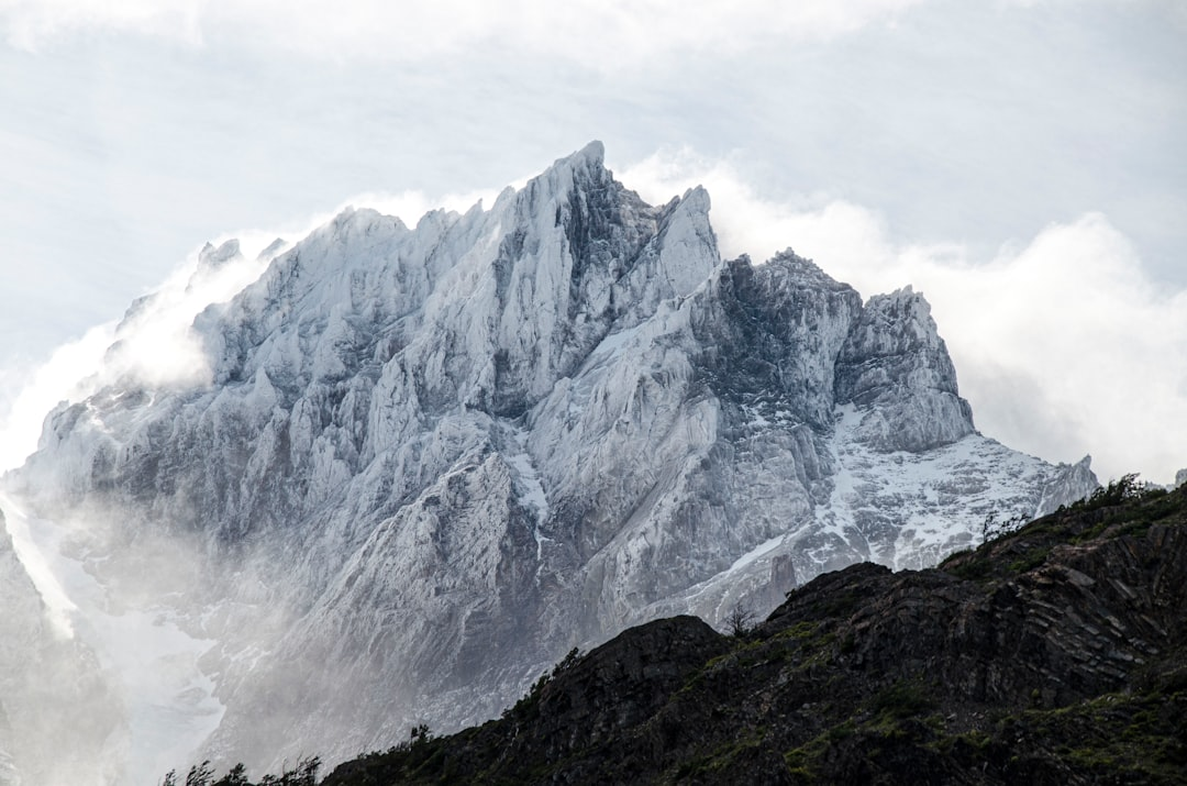
- ➡️ U-shaped Valleys (Glacial Troughs): Valleys that have been widened and deepened by glacial erosion, forming a characteristic U-shape in cross-section, unlike the V-shape of river valleys.
- ➡️ Cirques: Amphitheater-shaped basins found at the head of glacial valleys, often containing tarns (small lakes).
- ➡️ Aretes: Sharp, knife-edge ridges formed when two cirques erode back-to-back or side-by-side. For a deeper look at these fascinating geological features, explore our article on Aretes in Geology.
- ➡️ Horns: Sharp, pyramid-like peaks formed when three or more cirques erode a mountain from multiple sides.
- ➡️ Fjords: Long, narrow, deep inlets of the sea, bordered by steep cliffs, formed when glacial valleys are flooded by rising sea levels.
🪨 Depositional Landforms
As glaciers melt and retreat, they leave behind vast amounts of unsorted sediment, known as glacial till, creating a variety of unique depositional landforms.
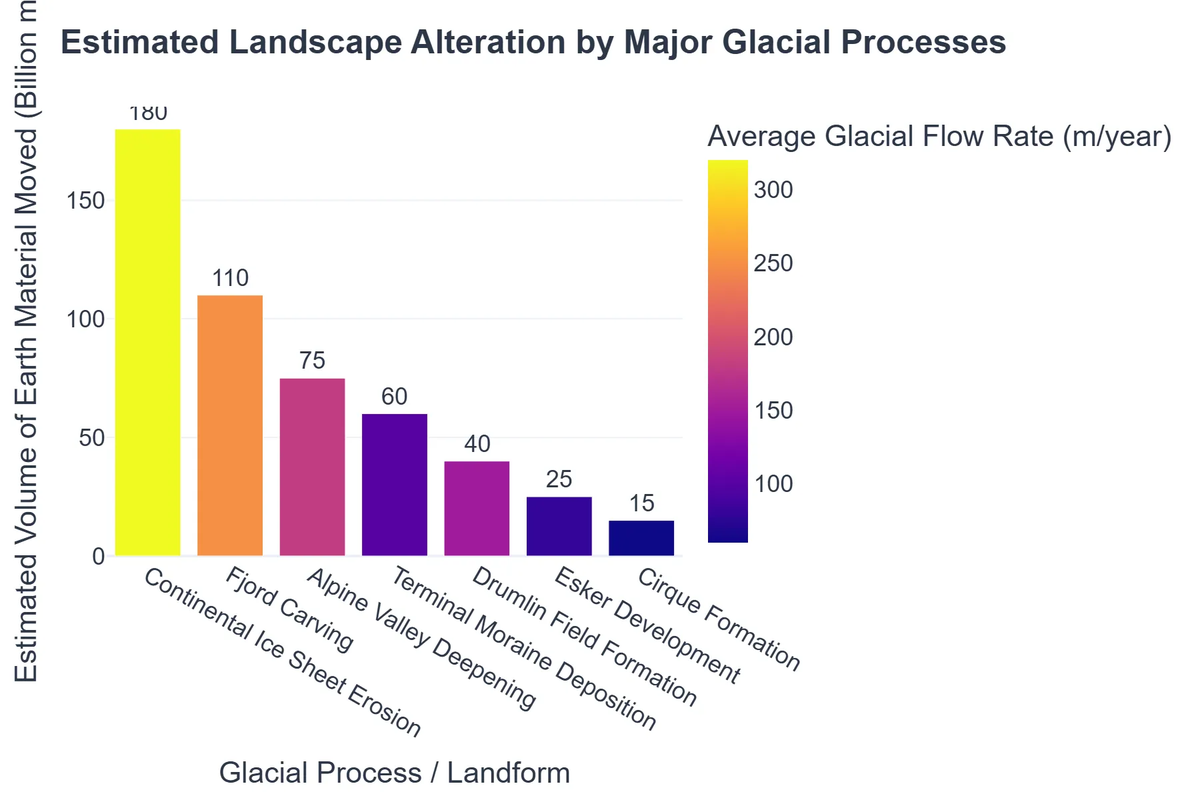
- ➡️ Moraines: Ridges of till deposited along the edges or terminus of a glacier. These include terminal, lateral, medial, and ground moraines.
- ➡️ Drumlins: Elongated, teardrop-shaped hills of till, often occurring in fields, indicating the direction of ice flow.
- ➡️ Eskers:2: Long, winding ridges of sand and gravel, deposited by meltwater streams flowing within or beneath a glacier.
- ➡️ Kames: Irregularly shaped hills of sand and gravel, often formed by sediment deposition in depressions on the glacier surface.
- ➡️ Outwash Plains: Flat or gently sloping plains formed by glacial meltwater streams carrying and depositing sediment beyond the glacier’s terminus.
The Legacy of Ice Ages: A Global Impact
While present-day glaciers are impressive, their influence pales in comparison to the immense scale of past ice ages. These prolonged periods of global cooling dramatically reshaped entire continents.
🌍 Major Glacial Periods
Earth has experienced multiple ice ages throughout its history, with the most recent, the Quaternary Glaciation, beginning about 2.6 million years ago and profoundly impacting the modern landscape. During peak glacial periods, vast ice sheets covered significant portions of North America, Europe, and Asia.
🔍 Reconstructing Past Climates
The study of glacial landforms, along with ice cores and fossil records, allows geologists to reconstruct past climatic conditions. These ancient icy archives provide invaluable data for understanding natural climate variability and the long-term trends of our planet.
Modern Glacial Dynamics and Climate Change
Today, glaciers serve as critical indicators of global climate change. Their ongoing retreat and thinning provide stark evidence of a warming planet.
📉 Retreating Glaciers: A Telling Sign
Almost all glaciers worldwide are currently retreating, often at accelerating rates. This retreat is a direct consequence of rising global temperatures, leading to increased melting and reduced accumulation. The observation of these changes offers compelling real-time data on the impacts of climate shifts.
🌊 Implications for Sea Level and Ecosystems
The melting of glaciers and ice sheets contributes significantly to global sea-level rise, threatening coastal communities and ecosystems worldwide. Beyond sea level, glacial meltwater feeds many rivers, and their disappearance has profound implications for freshwater availability for millions of people and for specialized ecosystems such as coastal seagrass meadows.
Studying Glacial Geology: Tools and Techniques
Modern glacial geology employs a blend of traditional fieldwork and cutting-edge technology to understand these massive ice bodies and their impact.
🔬 Fieldwork and Remote Sensing
Geologists conduct fieldwork to map landforms, analyze sediments, and measure ice movement. This is complemented by remote sensing technologies, such as satellite imagery and aerial photography, which allow for monitoring of vast areas and tracking changes over time. Radar and lidar are also used to peer beneath the ice and map subglacial topography.
📊 Glacial Models and Projections
Sophisticated computer models are used to simulate glacial behavior, predict future ice melt, and project contributions to sea-level rise. These models integrate data from various sources, helping scientists understand complex interactions within the Earth’s climate system.
Recommended Video
Conclusion
The study of glacial geology reveals a dynamic interplay between immense natural forces and the very fabric of our planet. From the dramatic sculpting of mountains to the subtle shaping of plains, glaciers are architects of Earth’s surface, leaving behind indelible marks that speak of incredible power and immense timescales. As key components of the cryosphere, they also stand as silent sentinels, reflecting the health of our global climate.
Understanding these processes is more vital than ever, as we grapple with the accelerating impacts of climate change on these majestic ice bodies. By delving into the hidden dynamics of our planet, we gain not only a profound appreciation for Earth’s geological past but also crucial insights into its future.
Frequently Asked Questions
What is glacial geology?
Glacial geology is the study of landforms created by glaciers and the processes of erosion and deposition carried out by ice sheets and valley glaciers.
How do glaciers shape landscapes?
Glaciers shape landscapes through abrasion, plucking, and freeze-thaw cycles, leading to the formation of U-shaped valleys, cirques, arêtes, and depositing features like moraines and drumlins.
What are some common landforms created by glaciers?
Common glacial landforms include fjords, cirques, moraines (terminal, lateral, medial), drumlins, eskers, kames, and erratics.
How do scientists study past glacial activity?
Scientists study past glacial activity by analyzing glacial landforms, sediment deposits (tills), ice cores, and examining fossil records and pollen preserved in ancient sediments.