

La Niña Year Prediction: Decoding Global Weather Trends
As inhabitants of Earth, we are constantly subject to the planet’s vast, often unseen forces. Among the most influential of these are the periodic climate phenomena that reshape weather patterns across the globe. One such critical force is La Niña, a complex oceanic and atmospheric event with far-reaching consequences. Understanding whether we are entering a la nina year is crucial for everything from agriculture to disaster preparedness, making accurate climate predictions an invaluable asset.
💡 Key Takeaways
- La Niña typically brings cooler Pacific ocean temperatures and distinct global weather shifts.
- Regional impacts vary significantly, from increased rainfall in some areas to droughts in others.
- Understanding La Niña’s predictions is crucial for preparedness in agriculture, energy, and disaster management.
- Climate models are continuously refined to improve the accuracy of La Niña forecasts.
“La Niña years are powerful drivers of atmospheric circulation, creating ripple effects across continents. Our challenge is to precisely map these teleconnections to inform communities and industries.”
— Marcus Sterling, Geophysical Explorer & Climate Dynamics Analyst
This article aims to be your most comprehensive guide to La Niña year predictions, offering insights into the science, expected global weather trends, and how communities can prepare. We delve into the intricate dynamics that govern our planet’s climate, offering a clear perspective on what to expect.
In This Article
- → La Niña Year Prediction: Decoding Global Weather Trends
- — 💡 Key Takeaways
- → Understanding La Niña: The Basics of a Climate Phenomenon
- — 🌊 How La Niña Forms
- → The Science of La Niña Year Prediction
- — 🔬 Key Indicators Monitored
- — 🖥️ Role of Climate Prediction Center Reports and Models
- → Current La Niña Forecasts: Is a La Niña Year Imminent?
- — 🗓️ Understanding Seasonal Outlooks
- → Expected Global Weather Trends During a La Niña Year
- — 🌍 Regional Impacts and Their Characteristics
- → Preparing for La Niña’s Influence: Mitigation and Adaptation
- — 🌱 Sector-Specific Preparations
- — 💡 Importance of Timely Climate Predictions
- → La Niña in the Broader Climate Context
- — 🔄 Interplay with Other Climate Drivers
- → Conclusion: Staying Ahead of the Weather Curve
Understanding La Niña: The Basics of a Climate Phenomenon
La Niña, meaning “the little girl” in Spanish, is a recurring oceanic and atmospheric phenomenon that is part of the broader El Niño-Southern Oscillation (ENSO) cycle. It’s characterized by the anomalous cooling of sea surface temperatures across the equatorial Pacific Ocean, specifically in the central and eastern regions. This cooling is not just a localized event; it triggers a cascade of atmospheric responses that ripple across the globe, significantly influencing global weather trends.
While often discussed alongside its counterpart, El Niño, it’s vital to grasp their distinct characteristics. For a detailed comparison, explore our guide on El Niño vs. La Niña: Understanding Climate Impacts.
🌊 How La Niña Forms
- ✅ Stronger Trade Winds: La Niña conditions are driven by an intensification of the Pacific trade winds, which blow from east to west.
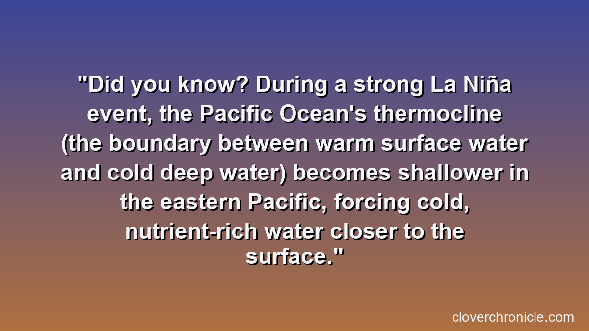
- ✅ Enhanced Upwelling: These stronger winds push warm surface water westward, allowing cooler, nutrient-rich water from the ocean depths to rise to the surface in the eastern Pacific.
- ✅ Atmospheric Feedback: The cooler ocean surface then influences atmospheric pressure patterns, reinforcing the stronger trade winds and creating a positive feedback loop.
The duration and intensity of La Niña events vary, typically lasting between 9 and 12 months, though some can persist for multiple years.
The Science of La Niña Year Prediction
Forecasting a la nina year is a complex undertaking, relying on sophisticated scientific models and real-time observational data. Meteorologists and climatologists worldwide collaborate to monitor key indicators, providing insights into the likelihood of La Niña’s development and its potential strength. This process is critical for anticipating global weather trends.
🔬 Key Indicators Monitored
- ➡️ Sea Surface Temperatures (SSTs): Anomalies in SSTs across the Niño 3.4 region of the equatorial Pacific are the primary indicator. Sustained cooling below a certain threshold signals La Niña.
- ➡️ Ocean Heat Content: Scientists also look at temperatures below the ocean surface, as subsurface warming or cooling can precede changes at the surface.
- ➡️ Atmospheric Pressure: The Southern Oscillation Index (SOI), which measures the difference in sea-level pressure between Tahiti and Darwin, Australia, provides insight into atmospheric circulation patterns associated with ENSO.
- ➡️ Trade Wind Strength: Monitoring the strength and direction of trade winds offers further clues.
🖥️ Role of Climate Prediction Center Reports and Models
Leading institutions globally, such as the National Oceanic and Atmospheric Administration’s (NOAA) Climate Prediction Center (CPC), regularly issue comprehensive climate predictions. These Climate Prediction Center reports synthesize data from various climate models, including statistical and dynamical models, to produce forecasts. These models simulate the ocean and atmosphere’s behavior, offering probabilities for the onset, duration, and intensity of La Niña. Staying informed with these authoritative reports is essential for anyone impacted by seasonal weather shifts.
For more on how these complex systems interact, delve into La Niña: A Comprehensive Guide to This Climate Phenomenon.
Current La Niña Forecasts: Is a La Niña Year Imminent?
Determining if a la nina year is on the horizon requires continuous monitoring of the evolving climate conditions. Forecasts are dynamic and subject to change, reflecting the complex interactions within the Earth’s climate system. Generally, predictions are issued with probabilities, indicating the likelihood of La Niña conditions developing, persisting, or decaying over a specific period.
🗓️ Understanding Seasonal Outlooks
Climatic organizations like the World Meteorological Organization (WMO) and national weather agencies provide seasonal outlooks that indicate the probability of ENSO phases. For instance, after an El Niño event, there is often a tendency for the system to transition towards neutral or La Niña conditions, though this is not guaranteed. These outlooks are crucial for long-range planning related to agriculture, water resources, and emergency management.
While specific predictions for “la nina this year” are best sourced directly from official meteorological agencies, the general pattern involves:
- ➡️ Monitoring a transition period following El Niño.
- ➡️ Observing sustained cooling in the equatorial Pacific.
- ➡️ Analyzing shifts in atmospheric patterns consistent with La Niña.
For the most up-to-date global forecasts, reliable sources like WMO’s El Niño/La Niña updates provide the latest scientific consensus.
Expected Global Weather Trends During a La Niña Year
A la nina year significantly alters global atmospheric circulation, leading to predictable shifts in weather patterns across different regions. While specific impacts can vary based on the strength and duration of the event, certain general trends emerge, affecting everything from rainfall to temperature extremes.
🌍 Regional Impacts and Their Characteristics
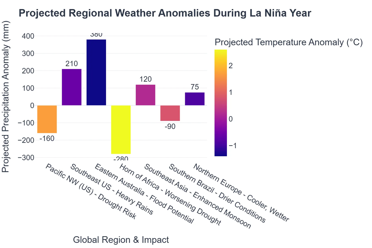
- ✅ North America:
- 💡 Southern U.S.: Often experiences drier-than-average conditions, increasing drought risk.
- 💡 Pacific Northwest and Northern Plains: Typically sees wetter and colder winters.
- 💡 Southeast U.S.: Cooler temperatures.
- 💡 Atlantic Hurricane Season: La Niña often correlates with an increased likelihood of an active hurricane season due to reduced wind shear in the Atlantic basin.
- ✅ South America:
- 💡 Northern South America: Tendency for above-average rainfall.
- 💡 Southern Brazil and Argentina: Often face drier conditions.
- ✅ Asia and Australia:
- 💡 Southeast Asia and Australia: Typically experience above-average rainfall, increasing flood risks.
- 💡 India: Can influence monsoon patterns, sometimes leading to stronger monsoons.
- ✅ Africa:
- 💡 Southern Africa: Generally experiences above-average rainfall.
- 💡 East Africa: Often sees drier conditions, exacerbating drought.
These are broad generalizations, and the actual impact can be modified by other climate drivers. For a more detailed breakdown of these effects, read our comprehensive article on La Niña Weather Pattern: Impact on Global Weather.
Preparing for La Niña’s Influence: Mitigation and Adaptation
Given the significant impacts of a la nina year on global weather trends, preparedness and adaptation strategies are paramount. From national-level planning to individual household adjustments, understanding the potential changes allows for more resilient communities and economies.
🌱 Sector-Specific Preparations
- ➡️ Agriculture: Farmers can adjust crop choices, planting schedules, and irrigation strategies based on seasonal rainfall forecasts. Drought-resistant crops or improved water harvesting techniques become crucial in anticipated dry areas.
- ➡️ Water Management: Water authorities can optimize reservoir levels, implement water conservation measures, and plan for potential shortages or excesses.
- ➡️ Disaster Preparedness: Regions prone to increased rainfall or drought need to update flood mitigation plans, manage fire risks, and educate the public on emergency responses. Coastal areas in the Atlantic should prepare for potentially more active hurricane seasons.
- ➡️ Energy Sector: Energy providers can anticipate shifts in demand due to temperature anomalies (e.g., higher demand for heating in colder regions, lower demand for cooling in cooler regions).
💡 Importance of Timely Climate Predictions
The value of accurate and timely climate predictions cannot be overstated. By leveraging data from sources like the Climate Prediction Center, governments, businesses, and individuals can make informed decisions to mitigate negative impacts and capitalize on potential benefits. This proactive approach is fundamental to navigating the hidden dynamics of our planet and building resilience against extreme weather events.
La Niña in the Broader Climate Context
While La Niña is a natural climate phenomenon, its impacts can be amplified or altered by ongoing climate change. The baseline conditions of our planet are shifting, leading to warmer oceans and a more energetic atmosphere. This means that while La Niña itself is not caused by human activity, its manifestations – such as intense rainfall or severe droughts – may occur in a world already experiencing more extreme weather.
Understanding La Niña within the context of global warming is crucial for truly grasping Earth’s Unseen Forces: The Hidden Dynamics of Our Planet. The scientific community continues to research the complex interplay between natural climate variability and long-term climate trends. For further reading on this critical subject, explore Global Weather Patterns and Climate Change: An In-depth Guide.
🔄 Interplay with Other Climate Drivers
La Niña does not act in isolation. Its effects can be modulated by other climate phenomena, such as the Indian Ocean Dipole (IOD) or the Pacific Decadal Oscillation (PDO). These interactions add layers of complexity to long-range forecasts, making the science of climate prediction a continuously evolving field.
Recommended Video
Frequently Asked Questions
What is La Niña?
La Niña is a climate pattern that describes the cooling of surface ocean waters along the tropical Pacific coast, affecting global weather patterns by altering atmospheric circulation.
How does La Niña differ from El Niño?
El Niño involves the warming of these Pacific waters, leading to opposite global weather effects compared to La Niña’s cooling influence. They are opposite phases of the ENSO cycle.
What are common global impacts of La Niña?
La Niña can lead to increased rainfall in Southeast Asia and Australia, drier conditions in the southern U.S., and a more active Atlantic hurricane season, among other regional shifts.
Can La Niña predictions be wrong?
While climate models are highly advanced, natural variability and other climate drivers mean predictions have a degree of uncertainty. Forecasts are continuously updated based on new data.