

In the vast and intricate tapestry of our planet, hidden forces continuously shape the landscapes we inhabit, the water we drink, and the air we breathe. Understanding these complex dynamics is not just a scientific endeavor; it’s crucial for human safety, resource management, and environmental stewardship. At the forefront of this critical mission stands the USGS – the United States Geological Survey.
💡 Key Takeaways
- The USGS is the primary scientific agency for Earth sciences in the United States.
- They monitor and research natural hazards such as earthquakes, volcanoes, and landslides.
- USGS provides essential data on water resources, ecosystems, and climate change impacts.
- Their work is crucial for public safety, resource management, and informed decision-making.
“The USGS isn’t just a data repository; it’s the heartbeat of our planetary understanding, providing the foundational insights we need to navigate a rapidly changing Earth and safeguard its future.”
— Marcus Sterling, Geophysical Explorer & Climate Dynamics Analyst
The United States Geological Survey USGS serves as the nation’s premier science agency, dedicated to providing impartial information about the health of our ecosystems and environment, the natural hazards that threaten us, the natural resources we rely on, and the impacts of climate and land-use change. From tracking earthquakes to mapping mineral deposits, and from monitoring water quality to assessing ecosystem health, the USGS is truly a guardian of Earth’s dynamics, offering insights that are indispensable for policy-makers, researchers, and the public alike.
In This Article
- — 💡 Key Takeaways
- → What is the USGS? A Core Mission Overview
- — 🌍 Roots and Evolution of the United States Geological Survey USGS
- — 🎯 Core Mandates and Responsibilities
- → Monitoring Earth’s Pulse: Seismic and Volcanic Activity
- — 🌋 Earthquake Monitoring and Hazards
- — 🔥 Volcanic Surveillance and Warning Systems
- → Understanding Our Water Resources
- — 💧 Hydrologic Research and Data Collection
- — 📊 Water Quality and Availability Studies
- → Mapping the Landscape: Geology, Topography, and Ecosystems
- — 🗺️ Geological Mapping and Mineral Resources
- — 🌳 Ecosystem Science and Land Use Change
- → Data Powerhouse: USGS Data Services and Accessibility
- — 💻 Accessing USGS Data Services and Resources
- — 📚 The Value of USGS Publications
- → Collaborative Science: Partnering for a Safer Planet
- — 🤝 Inter-Agency Cooperation and Global Reach
- — 🔬 Supporting Scientific Research and Innovation
- → Conclusion
What is the USGS? A Core Mission Overview
The US Geological Survey USGS is a scientific agency of the United States government. Its scientists study the landscape of the United States, its natural resources, and the natural hazards that threaten it. The Survey has four major science mission areas: Ecosystems, Energy and Minerals, Natural Hazards, and Water Resources.
🌍 Roots and Evolution of the United States Geological Survey USGS
Established on March 3, 1879, the USGS was initially tasked with classifying public lands and examining the geological structure, mineral resources, and products of the national domain. Over its more than 140-year history, its mandate has expanded significantly, adapting to new scientific challenges and societal needs. Today, it stands as a comprehensive earth science agency, integrating diverse disciplines to provide holistic insights into our planet.
- ✅ Historical Mandate: Initially focused on geological mapping and resource assessment in the American West.
- ✅ Expansion: Grew to include water resources, natural hazards, ecosystems, and climate change research.
- ✅ Modern Role: A multi-disciplinary scientific agency serving the nation and the world with objective earth science information.
🎯 Core Mandates and Responsibilities
The mission of the USGS is broad, but its core revolves around providing unbiased, timely, and relevant scientific information. This information is vital for decision-making regarding natural resources, environmental quality, and national safety.
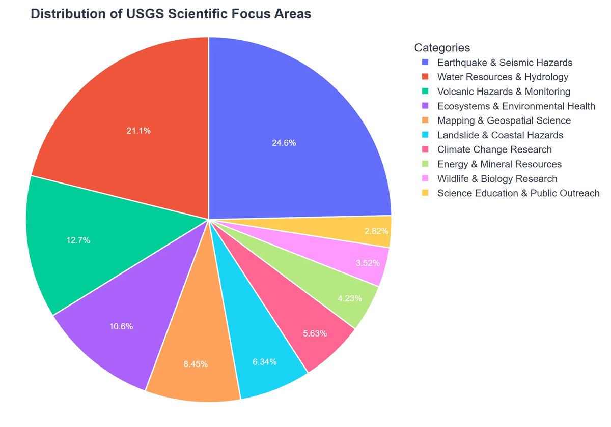
- ➡️ Natural Hazards: Monitoring and assessing risks from earthquakes, volcanoes, landslides, floods, and wildfires.
- ➡️ Water Resources: Evaluating the quantity and quality of surface and groundwater resources.
- ➡️ Energy and Minerals: Assessing the nation’s energy and mineral resources.
- ➡️ Ecosystems: Understanding biological processes and the impacts of environmental change on ecosystems.
- ➡️ Core Science Systems: Providing foundational data, maps, and remote sensing capabilities.
Monitoring Earth’s Pulse: Seismic and Volcanic Activity

One of the most critical roles of the USGS is its vigilance over Earth’s dynamic and often unpredictable movements. Through sophisticated networks and cutting-edge research, it provides vital early warnings and foundational data on seismic and volcanic hazards.
🌋 Earthquake Monitoring and Hazards
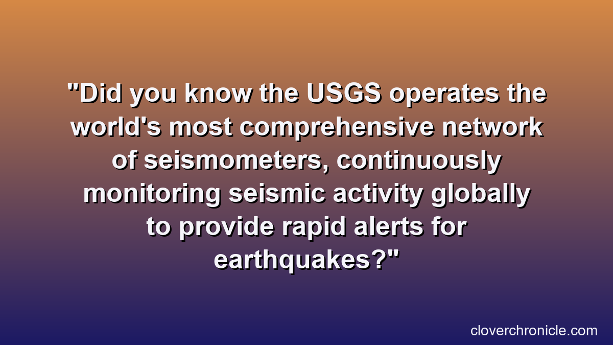
The USGS operates the National Earthquake Information Center (NEIC), which rapidly determines the location and size of all significant earthquakes worldwide. This information is crucial for emergency response and for informing the public about potential dangers. Their work extends to developing seismic hazard maps, crucial tools for designing earthquake-resistant infrastructure.
- 💡 Early Warning Systems: Research and development into systems like ShakeAlert, providing seconds of warning before strong shaking.
- 💡 Seismic Networks: Maintaining extensive networks of seismometers across the U.S. and globally.
- 💡 Hazard Assessment: Producing national seismic hazard maps used in building codes and land-use planning.
🔥 Volcanic Surveillance and Warning Systems
With numerous active volcanoes across the U.S. territories, particularly in Alaska, Hawaii, and the Pacific Northwest, the USGS operates five volcano observatories. These observatories continuously monitor volcanic activity, providing alerts and forecasts that save lives and mitigate economic impacts.
For more insights into the broader field of Earth science, exploring topics like plate tectonics and rock cycles, we recommend visiting Geoscience: Decoding Earth’s Dynamic Systems.
Understanding Our Water Resources
Water is life, and the USGS plays an indispensable role in monitoring, assessing, and researching the nation’s water resources. Their data and scientific expertise are fundamental to managing water supply, addressing pollution, and mitigating flood and drought impacts.
United States Geological Survey (USGS): Strengths and Challenges
Pros
- ✔Provides critical scientific data on natural hazards and resources.
- ✔Essential for public safety and disaster preparedness efforts.
- ✔Conducts foundational, long-term Earth science research.
- ✔Offers extensive publicly accessible data and mapping tools.
Cons
- ✖Vulnerable to governmental funding fluctuations and budget cuts.
- ✖Bureaucratic processes can sometimes hinder agility and innovation.
- ✖Scope and pace of certain research areas may be limited by resources.
- ✖Data complexity may require expert interpretation for optimal use.
💧 Hydrologic Research and Data Collection
The USGS maintains thousands of streamgages across the country, providing real-time data on streamflow, river levels, and water temperature. This data is critical for flood forecasting, drought monitoring, and water management for agriculture, industry, and municipal use.
- ✅ Streamflow Data: Real-time information for flood prediction, drought monitoring, and water allocation.
- ✅ Groundwater Levels: Monitoring changes in aquifers to understand long-term water availability.
- ✅ Water Use: Compiling data on how water is withdrawn and used across different sectors.
📊 Water Quality and Availability Studies
Beyond quantity, the quality of our water is paramount. The USGS conducts extensive research on water chemistry, contaminants, and the health of aquatic ecosystems. These studies inform regulatory decisions and public health initiatives.
To deepen your understanding of geological insights and data, you might also find value in exploring Top Geology Websites: Your Earth Science Knowledge Gateway, which often feature collaborations or data from the USGS.
Mapping the Landscape: Geology, Topography, and Ecosystems
From the depths of geological formations to the intricacies of ecological interactions, the USGS maps and studies every facet of the American landscape, providing foundational knowledge for countless applications.
🗺️ Geological Mapping and Mineral Resources
The creation of detailed geological maps is a cornerstone of the US Geological Survey‘s work. These maps are essential for identifying natural resources, assessing geological hazards, and informing land-use planning. The agency also assesses domestic and global mineral resources, providing critical information for economic security.
EcoBuild Developments Mitigates Risk and Accelerates Approvals with USGS Data
❓The Challenge
EcoBuild Developments faced significant uncertainty and potential delays for a new residential project due to its location near a complex geological fault line and concerns about water availability, leading to high insurance quotes and permit challenges.
💡The Solution
By proactively integrating USGS Natural Hazards data for seismic activity and Water Resources assessments into their initial site analysis and engineering plans, EcoBuild gained precise, unbiased scientific insights into localized risks and resource availability.
🏆The Result
This data-driven approach allowed EcoBuild to reduce their project’s risk-related insurance premiums by 18% and accelerated permit approval by 45 days due to demonstrated adherence to safety and sustainability standards.
- 💡 Geologic Maps: Fundamental for understanding subsurface structures, resource distribution, and hazard zones.
- 💡 Mineral Assessments: Identifying deposits of critical minerals vital for technology and industry.
- 💡 Energy Resources: Evaluating oil, gas, coal, and geothermal potential.
🌳 Ecosystem Science and Land Use Change
The USGS investigates the health of ecosystems and the impacts of land-use change, climate change, and invasive species. Their research provides the scientific basis for conserving biodiversity and managing natural resources sustainably. This includes detailed studies like their efforts in monitoring Arctic and boreal ecosystems through the assimilation of field-based data, showcasing their commitment to understanding complex environmental shifts.
For a broader perspective on how human activities intersect with geological processes, consider reading our article on Human Geology: How We Reshape the Earth’s Surface, which touches upon the anthropocentric impacts on our planet’s geology.
Data Powerhouse: USGS Data Services and Accessibility
A hallmark of the USGS is its commitment to open science and data accessibility. The sheer volume and quality of USGS data services make it an invaluable resource for scientists, educators, and the public worldwide.
💻 Accessing USGS Data Services and Resources
The US Geological Survey website serves as a gateway to an immense repository of scientific data, maps, and tools. From real-time earthquake maps to historical aerial photography and climate models, their data is readily available for download and integration into various research and planning initiatives. Their commitment to data sharing mirrors the open-source philosophy seen in major space agencies, like NASA’s Earthdata portal, which provides a gateway to vast Earth observation data (NASA Earthdata: Your Gateway to NASA Earth Observation Data).
- ✅ EarthExplorer: Access to satellite imagery, aerial photographs, and other remote sensing data.
- ✅ National Water Information System (NWIS): Real-time and historical water data.
- ✅ ScienceBase: A collaborative platform for managing and sharing scientific data and information.
- ✅ The National Map: Topographic maps, elevation data, hydrography, and more.
📚 The Value of USGS Publications
Beyond raw data, USGS publications comprise a vast library of scientific reports, journals, maps, and educational materials. These publications document research findings, methodologies, and analyses, providing critical insights into various earth science topics. They are peer-reviewed and represent the culmination of rigorous scientific inquiry, making them highly trusted resources for anyone seeking authoritative information.
- ➡️ Scientific Investigations Reports: Detailed reports on specific research projects.
- ➡️ Professional Papers: Comprehensive and authoritative reports on scientific investigations.
- ➡️ Data Releases: Companion products to publications, making underlying data accessible.
- ➡️ Fact Sheets: Concise summaries of key scientific findings for a broader audience.
Collaborative Science: Partnering for a Safer Planet
The USGS doesn’t operate in a vacuum. Its impact is amplified through extensive collaborations with other government agencies, academic institutions, international bodies, and the private sector. This collaborative approach fosters innovation and ensures that scientific findings are translated into actionable solutions.
🤝 Inter-Agency Cooperation and Global Reach
The USGS works closely with other federal agencies like FEMA (Federal Emergency Management Agency), NOAA (National Oceanic and Atmospheric Administration), and the Department of Defense, particularly in hazard response and resource management. Globally, the USGS contributes to international scientific programs and provides expertise to countries facing similar environmental and geological challenges, sharing data and best practices to address shared global concerns.
🔬 Supporting Scientific Research and Innovation
By making its data publicly available and fostering research grants, the USGS acts as a catalyst for scientific advancement. It supports a vibrant community of researchers who leverage USGS data services to conduct their own studies, pushing the boundaries of earth science knowledge and developing new technologies for monitoring and understanding our planet.
Recommended Video
Conclusion
The USGS stands as an unwavering pillar of scientific inquiry and public service. Through its relentless pursuit of understanding Earth’s complex systems – from the tremors beneath our feet to the flow of our rivers and the health of our ecosystems – it provides the foundational knowledge necessary for informed decision-making. As we navigate the complexities of climate change, natural hazards, and resource demands, the work of the United States Geological Survey USGS becomes ever more critical, safeguarding our future by illuminating the Earth’s Unseen Forces: The Hidden Dynamics of Our Planet.
Frequently Asked Questions
What is the primary mission of the USGS?
The USGS serves as the nation’s largest water, Earth, and biological science and civilian mapping agency, providing scientific information to describe and understand the Earth.
How does the USGS contribute to public safety?
They monitor and research natural hazards like earthquakes, volcanic eruptions, and landslides, issuing warnings and providing data to mitigate risks and inform emergency response.
Does the USGS conduct climate change research?
Yes, the USGS conducts extensive research on climate change impacts, including glacier retreat, sea-level rise, and ecosystem shifts, to inform adaptation strategies.
Where can I access USGS data and publications?
The USGS makes vast amounts of its data, maps, and scientific publications freely available online through its official website and various data portals.