

Regional Geology: Mapping Earth’s Hidden Structures
Our planet is a dynamic, ever-changing entity, shaped by forces both visible and unseen. Beneath our feet lies a complex tapestry of rocks, faults, folds, and ancient landscapes, each telling a story of Earth’s deep past and influencing its present. Understanding these intricate subsurface dynamics is the cornerstone of regional geology – a specialized field dedicated to deciphering the geological architecture of specific areas.
💡 Key Takeaways
- Regional geology analyzes large-scale geological features to understand Earth’s processes and history.
- Geological mapping is a core technique, revealing rock types, structures, and their spatial relationships across vast areas.
- This field provides critical insights for natural resource discovery, hazard assessment, and land-use planning.
- It helps decipher Earth’s long-term tectonic evolution and its impact on climate dynamics.
“Regional geology isn’t just about mapping rocks; it’s about decoding Earth’s grand narrative. Every fault line, every uplift, tells a story of energy transfer and climate influence across millennia, vital for understanding our planet’s future.”
— Marcus Sterling, Geophysical Explorer & Climate Dynamics Analyst
This comprehensive guide delves into the world of regional geology and the critical process of geological mapping, exploring why these practices are indispensable for everything from resource discovery to hazard mitigation and informed land-use planning. Join us as we uncover how geoscientists meticulously chart Earth’s structures, revealing the hidden forces that shape our world.
In This Article
- → Regional Geology: Mapping Earth’s Hidden Structures
- — 💡 Key Takeaways
- → What is Regional Geology?
- — 🗺️ Defining the Scope
- — 🔬 Key Elements of Study
- → The Core Principles of Geological Mapping
- — 📜 Stratigraphy and Chronology
- — 💥 Structural Geology and Tectonics
- — ⛰️ Petrology and Mineralogy
- → Why is Regional Geological Mapping Crucial?
- — ⛏️ Resource Exploration
- — ⚠️ Hazard Assessment
- — 🏗️ Land-Use Planning and Engineering
- — 🧪 Fundamental Scientific Understanding
- → Tools and Techniques in Modern Geological Mapping
- — 🛰️ Remote Sensing and GIS
- — 🚶 Fieldwork and Data Collection
- — 🧪 Laboratory Analysis
- → Challenges and Advancements in Mapping Earth’s Structures
- — 🏞️ Complex Terrains and Subsurface Mapping
- — 📈 Integration of Big Data and AI
- → Real-World Applications and Case Studies
- → Conclusion
What is Regional Geology?
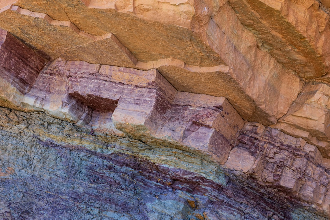
Regional geology is the study of the distribution, age, composition, and structure of rocks and geological features across a defined geographical area. Unlike focused studies on single outcrops or specific minerals, regional geology takes a macroscopic view, aiming to understand the entire geological framework of a region.
🗺️ Defining the Scope
- ✅ Broad Perspective: It encompasses large areas, from mountain ranges and sedimentary basins to entire continental blocks.
- ➡️ Integrated Approach: It integrates data from various geological disciplines, including stratigraphy, structural geology, petrology, geochronology, and geophysics.
- 💡 Contextual Understanding: The goal is to establish the geological history and evolution of the region, understanding how different rock units and structures relate to one another in space and time.
🔬 Key Elements of Study
Regional geologists investigate several fundamental elements to build a complete picture:
- ✅ Rock Formations: Identifying and characterizing different rock types (igneous, sedimentary, metamorphic) and mapping their lateral and vertical extent.
- ➡️ Structural Features: Analyzing faults, folds, joints, and other deformational structures that reveal the tectonic history of the area. For instance, understanding Compression in Geology: Folding and Faulting Earth’s Crust is vital for interpreting these features.
- 💡 Stratigraphy: Establishing the sequence and age relationships of rock layers, often correlated across vast distances.
- ✅ Geochronology: Dating rocks and geological events to establish a precise timeline of the region’s development.
- ➡️ Sedimentary Basins: Understanding the formation and evolution of Basin Geology: Formation and Resource Potential for their significance in resource accumulation.
The Core Principles of Geological Mapping
Geological mapping is the primary tool of regional geology. It involves systematically documenting and representing geological features on a map, providing a visual summary of a region’s subsurface and surface geology. This process is fundamental to revealing Earth’s Unseen Forces: The Hidden Dynamics of Our Planet.
📜 Stratigraphy and Chronology
One of the first steps in geological mapping is establishing the stratigraphy – the study of rock layers (strata) and layering (stratification). This involves:
GeoUrban Planners Inc. Reduces Project Overruns by 25% with Regional Geology
❓The Challenge
GeoUrban Planners Inc. frequently encountered unexpected ground instability and subsurface issues during large-scale urban development projects, leading to costly redesigns and significant delays.
💡The Solution
By adopting a comprehensive approach to regional geology and integrating advanced geological mapping into their preliminary site assessments, GeoUrban gained a detailed understanding of the subsurface architecture, including fault lines and rock formations, as outlined in the provided guide.
🏆The Result
This proactive strategy enabled GeoUrban Planners Inc. to reduce project cost overruns related to unforeseen geological challenges by 25% and decrease overall project delays by an average of 15%.
- ✅ Identifying Rock Units: Differentiating distinct rock layers based on composition, texture, and fossil content.
- ➡️ Determining Age Relationships: Applying principles like the Law of Superposition (older layers are generally below younger ones) and using fossils or radiometric dating to assign relative or absolute ages.
- 💡 Correlation: Matching rock units across different locations to understand their lateral continuity and regional extent.
💥 Structural Geology and Tectonics
Understanding how rocks have been deformed by Earth’s internal forces is crucial:
- ✅ Mapping Folds: Identifying anticlines and synclines, which indicate compressional forces.
- ➡️ Charting Faults: Locating and characterizing fault lines, which are fractures in the Earth’s crust where significant movement has occurred. These can be active or inactive and are key to understanding earthquake potential.
- 💡 Interpreting Tectonic History: Reconstructing the regional stresses and movements of tectonic plates over geological time.
⛰️ Petrology and Mineralogy
Analyzing the rocks themselves provides critical insights:
- ✅ Rock Classification: Identifying the specific types of igneous, sedimentary, and metamorphic rocks present. For example, understanding Slate Geology: Formation, Properties, and Uses involves detailed petrological study.
- ➡️ Mineral Composition: Determining the minerals that make up the rocks, which can indicate their origin, formation conditions, and alteration history.
- 💡 Fabric Analysis: Studying the texture and arrangement of mineral grains, which can reveal deformational history.
Why is Regional Geological Mapping Crucial?
The detailed knowledge provided by regional geological mapping extends far beyond academic curiosity, offering tangible benefits across numerous sectors:
⛏️ Resource Exploration
Regional geological maps are the fundamental first step in locating valuable natural resources:
- ✅ Minerals: Identifying areas prospective for metallic ores (e.g., gold, copper), industrial minerals (e.g., limestone, aggregates), and gemstones.
- ➡️ Energy Resources: Pinpointing potential oil, natural gas, coal, and geothermal reservoirs by mapping relevant rock formations and structural traps.
- 💡 Groundwater: Mapping aquifers and understanding groundwater flow paths for sustainable water resource management.
⚠️ Hazard Assessment
Understanding regional geology is vital for mitigating natural disasters:
- ✅ Earthquakes: Mapping active fault lines and understanding seismic potential.
- ➡️ Landslides: Identifying unstable slopes, susceptible rock types, and areas prone to mass movements.
- 💡 Volcanic Activity: Delineating volcanic fields and assessing eruption hazards in volcanically active regions.
🏗️ Land-Use Planning and Engineering
Geological maps provide essential data for infrastructure development and environmental management:
- ✅ Construction: Assessing ground stability for buildings, bridges, and dams.
- ➡️ Waste Disposal: Identifying suitable sites for landfills and hazardous waste repositories, ensuring geological stability and containment.
- 💡 Environmental Protection: Understanding soil types, contaminant pathways, and areas sensitive to geological processes.
- For more on how human activities interact with geology, explore Human Geology: How We Reshape the Earth’s Surface.
🧪 Fundamental Scientific Understanding
Beyond practical applications, regional geological mapping advances our understanding of Earth processes:
- ✅ Plate Tectonics: Providing evidence for past and present plate movements, continental drift, and mountain building.
- ➡️ Climate History: Preserving records of ancient environments and climate changes within rock layers.
- 💡 Evolution of Life: Offering context for fossil discoveries and understanding biodiversity hotspots.
Tools and Techniques in Modern Geological Mapping
Modern geological mapping utilizes an array of advanced technologies combined with traditional fieldwork to create highly accurate and detailed maps.
🛰️ Remote Sensing and GIS
- ✅ Satellite Imagery & Aerial Photography: Providing vast spatial coverage, helping to identify large-scale structural features, rock unit boundaries, and landforms.
- ➡️ Lidar (Light Detection and Ranging): Creating high-resolution topographic models that can reveal subtle geological structures hidden beneath vegetation.
- 💡 Geographic Information Systems (GIS): Digital platforms for compiling, analyzing, and visualizing diverse geological data layers (e.g., rock types, fault lines, well locations). The U.S. Geological Survey’s National Geologic Map Database (NGMDB) is a prime example of such comprehensive data management.
🚶 Fieldwork and Data Collection
Despite technological advancements, direct observation remains irreplaceable:
- ✅ Outcrop Examination: Geologists physically visit rock exposures to measure orientations of rock layers and structures, collect samples, and record detailed observations.
- ➡️ Drilling and Coring: Obtaining subsurface samples to understand geology at depth.
- 💡 Geophysical Surveys: Using techniques like seismic reflection, gravity, and magnetic surveys to infer subsurface structures without direct drilling. For instance, the USGS utilizes these methods to study local and regional shallow-subsurface geology and structure.
🧪 Laboratory Analysis
- ✅ Petrographic Analysis: Studying thin sections of rocks under a microscope to identify minerals and textures.
- ➡️ Geochemical Analysis: Determining the chemical composition of rocks and minerals to understand their origin and alteration.
- 💡 Geochronological Dating: Using isotopic methods (e.g., U-Pb, Ar-Ar) to determine the absolute age of rocks and geological events.
Challenges and Advancements in Mapping Earth’s Structures
Regional geological mapping faces inherent challenges, but continuous advancements in technology and methodology are pushing the boundaries of what’s possible.
🏞️ Complex Terrains and Subsurface Mapping
- ✅ Accessibility: Remote, rugged, or densely vegetated areas pose significant logistical challenges for fieldwork.
- ➡️ Subsurface Complexity: Directly mapping geology deep beneath the surface is difficult, requiring indirect geophysical methods and interpretations from limited drill data.
- 💡 Data Integration: Combining vast amounts of diverse data types (field observations, remote sensing, geophysical data, laboratory analyses) into a cohesive 3D model.
📈 Integration of Big Data and AI
- ✅ Machine Learning: AI algorithms are being developed to assist in pattern recognition from remote sensing data and to predict geological features in unmapped areas.
- ➡️ 3D Geological Models: Advanced software allows for the creation of intricate 3D models that visualize subsurface geology, improving understanding for resource modeling and hazard assessment.
- 💡 Crowdsourcing and Citizen Science: While early in development, some initiatives explore how public participation could contribute to large-scale data collection.
Real-World Applications and Case Studies
The impact of regional geology is evident in countless projects worldwide. From the Geological Survey of India (GSI): Pioneering Earth Science mapping vast and diverse terrains to understanding the unique subsurface structures influencing resource extraction, the principles are universally applied.
- ✅ Mining Districts: Regional maps guide exploration for specific mineral deposits, improving targeting efficiency and reducing environmental impact.
- ➡️ Petroleum Basins: Detailed mapping of sedimentary basins helps identify potential hydrocarbon traps and reservoir rocks, critical for energy security.
- 💡 Urban Planning: In cities like Los Angeles, regional geological maps are vital for assessing earthquake hazards and ensuring safe construction practices.
- ✅ Water Management: Mapping of aquifers and groundwater flow systems is essential for sustainable water supply, particularly in arid regions.
Recommended Video
Conclusion
Regional geology and the art of geological mapping are much more than academic pursuits; they are fundamental disciplines that underpin our interaction with the Earth. By meticulously charting the planet’s hidden structures, geoscientists provide the essential framework for discovering resources, mitigating natural hazards, guiding responsible land use, and deepening our scientific understanding of this incredible planet.
As technology advances, the precision and depth of geological maps will continue to grow, offering even greater insights into Earth’s complex dynamics and ensuring a more sustainable future for all.
Frequently Asked Questions
What is regional geology?
Regional geology studies the large-scale distribution and relationships of rock units, structures, and landforms across vast geographical areas to understand their formation and evolution.
Why is geological mapping crucial?
Geological mapping is fundamental for identifying rock types, structural features, and their spatial arrangement, essential for resource exploration, hazard assessment, and informed land-use planning.
How does regional geology contribute to understanding Earth’s history?
By analyzing the distribution and deformation of geological features, regional geology helps reconstruct ancient environments, tectonic plate movements, and long-term climatic changes, revealing our planet’s deep past.