

Web Geology: Exploring Earth Science Online
In an age increasingly defined by digital connectivity, the field of Earth science is undergoing a profound transformation. No longer confined to laboratories, traditional field excursions, or dusty textbooks, geology is now accessible and explorable through a myriad of online platforms and tools. This evolving domain, often termed web geology, represents the intersection of geological science with internet technologies, offering unprecedented opportunities for research, education, and public engagement. From intricate global datasets to immersive virtual experiences, web geology is democratizing access to our planet’s complex processes and history.
💡 Key Takeaways
- The internet offers vast resources for studying geology, from academic databases to interactive simulations.
- Virtual field trips and online mapping tools provide immersive experiences for understanding geological formations.
- Web-based platforms are crucial for data visualization, helping analyze complex Earth science phenomena.
- Online tools foster a deeper appreciation for Earth’s processes and climate dynamics.
“Web geology democratizes access to Earth’s most complex systems. From global climate models to seismic activity, these online tools empower a new generation of scientists and enthusiasts to engage with our planet’s dynamics in unprecedented ways.”
— Marcus Sterling, Geophysical Explorer & Climate Dynamics Analyst
This article delves into the core components of web geology, exploring how digital resources are revolutionizing our understanding of Earth. We will examine the critical tools and platforms that define this new frontier, discuss their applications across various sectors, and ponder the future trajectory of Earth science in the digital realm. Whether you are a seasoned geologist, a student, or simply curious about the forces shaping our planet, web geology offers a powerful lens through which to observe, analyze, and comprehend Earth’s intricate dynamics.
In This Article
- → Web Geology: Exploring Earth Science Online
- — 💡 Key Takeaways
- → The Digital Transformation of Earth Science
- → Unearthing Data: Online Geological Databases
- — Types of Geological Databases
- — Access and Utility
- → Navigating the Digital Terrain: Interactive Mapping Tools
- — Features and Applications
- → Beyond the Classroom: Virtual Field Trip Platforms
- — Components of a Virtual Field Trip
- → Leveraging Web Geology for Research and Education
- — Enhancing Geological Research
- — Transforming Geological Education
- → Career Opportunities and Skills in Digital Earth Science
- — Emerging Roles and Required Skills
- → The Future of Web Geology: AI, VR, and Beyond
- → Conclusion
The Digital Transformation of Earth Science

The transition of geological study into the digital sphere is not merely about digitizing old maps; it’s about creating dynamic, interactive, and collaborative environments for Earth scientists and enthusiasts alike. This transformation began with the digitization of existing geological maps and reports, but quickly evolved to encompass real-time data streaming, sophisticated modeling, and immersive visualization techniques. The ability to access vast amounts of geological data from anywhere, at any time, has fundamentally altered the pace and scope of research and discovery.
Key drivers of this digital shift include advancements in:
- Data Collection Technologies: Satellites, drones, and advanced geophysical sensors generate petabytes of data requiring sophisticated digital platforms for storage and analysis.
- Computing Power: Enhanced processing capabilities allow for complex simulations and the visualization of large datasets.
- Internet Penetration: Widespread internet access enables global collaboration and dissemination of information.
- Software Development: Open-source and commercial software suites provide powerful tools for GIS (Geographic Information Systems), 3D modeling, and data analysis.
This convergence of technology with traditional Earth science methodologies has given rise to a vibrant ecosystem of digital tools and resources, making different types of geology more approachable and interconnected than ever before.
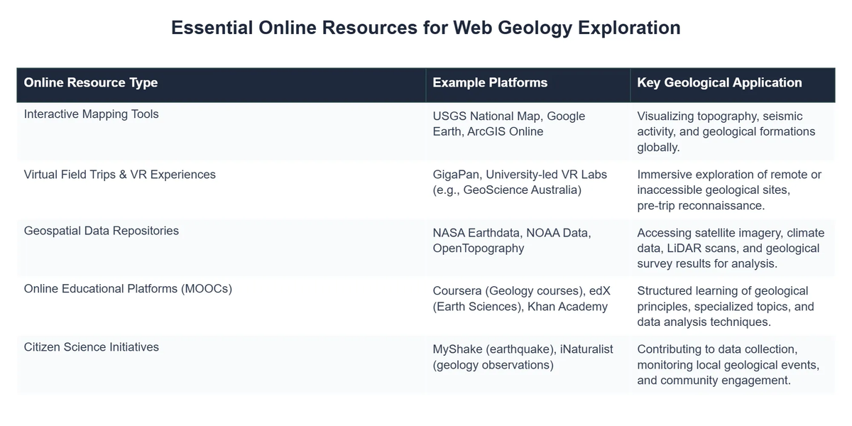
Unearthing Data: Online Geological Databases
At the heart of web geology are the vast repositories of information known as online geological databases. These digital archives compile and organize an immense array of data, from rock samples and seismic readings to historical surveys and borewell logs. They serve as indispensable resources for researchers, educators, and industry professionals, providing quick access to foundational information that would otherwise require extensive field work or library searches.
Types of Geological Databases
These databases can range from highly specialized collections to comprehensive national repositories:
- National Geological Surveys: Organizations like the U.S. Geological Survey (USGS) maintain extensive public databases encompassing topographic maps, geological maps, mineral resources data, water resources, and earthquake information. These are foundational for understanding regional geology.
- Academic and Research Consortia: Universities and research institutions often collaborate to create specialized databases, such as those focusing on specific geological periods, paleontology, or tectonic movements.
- Mineral and Energy Resource Databases: These databases contain information on the location, quantity, and characteristics of mineral deposits, oil, and natural gas reserves. They are crucial for exploration and resource management, directly impacting fields like oil and gas geology.
- Geophysical Data Repositories: Housing seismic data, gravity measurements, magnetic surveys, and other geophysical observations critical for subsurface imaging and understanding Earth’s internal structure and Earth’s unseen forces.
- Paleontological and Stratigraphic Databases: These focus on fossil records, rock layers, and the geological timescale, offering insights into ancient life and Earth’s history, including phenomena like Stromatolites.
Access and Utility
The primary utility of these databases lies in their accessibility and the ability to filter, analyze, and visualize data without needing specialized software or extensive computational resources on a local machine. Many offer APIs (Application Programming Interfaces) for developers to build custom applications or integrate data into their own systems, further extending their utility. They are fundamental for everything from academic research to risk assessment for infrastructure projects.
Navigating the Digital Terrain: Interactive Mapping Tools
Complementing geological databases are interactive mapping tools, which transform raw data into visual, navigable representations of Earth’s surface and subsurface. These tools are often built upon Geographic Information Systems (GIS) technology and allow users to overlay various data layers—geological maps, satellite imagery, elevation models, well locations, fault lines, and more—to gain a comprehensive understanding of a particular area.
Features and Applications
Modern interactive mapping tools offer a rich suite of features:
- Layer Management: Users can toggle different data layers on and off, adjust transparency, and reorder them to highlight specific features.
- Querying and Analysis: Ability to click on a point or select an area to retrieve detailed information, perform spatial analysis, or generate cross-sections.
- 3D Visualization: Many platforms offer 3D views, allowing users to experience topography and geological structures in a more immersive way, which is particularly useful for understanding complex formations like contact metamorphic aureoles.
- Time Series Analysis: For dynamic data such as seismic activity or glacier retreat, these tools can display changes over time, aiding in the study of Earth’s ongoing processes and Quaternary geology.
- Collaboration and Sharing: Many platforms allow users to create, share, and collaborate on maps, fostering community and collective understanding.
Examples of such tools include web-based GIS viewers provided by national geological surveys, academic projects offering global geological maps, and even commercial platforms providing access to high-resolution satellite imagery combined with geological overlays. NASA Earthdata, for instance, provides a gateway to vast amounts of Earth observation data, much of which can be visualized through interactive mapping interfaces, helping researchers analyze everything from climate patterns to dendritic patterns in geology. While specific proprietary platforms are numerous, the underlying principles of data integration and interactive visualization are what make them so powerful for exploring NASA Earthdata.
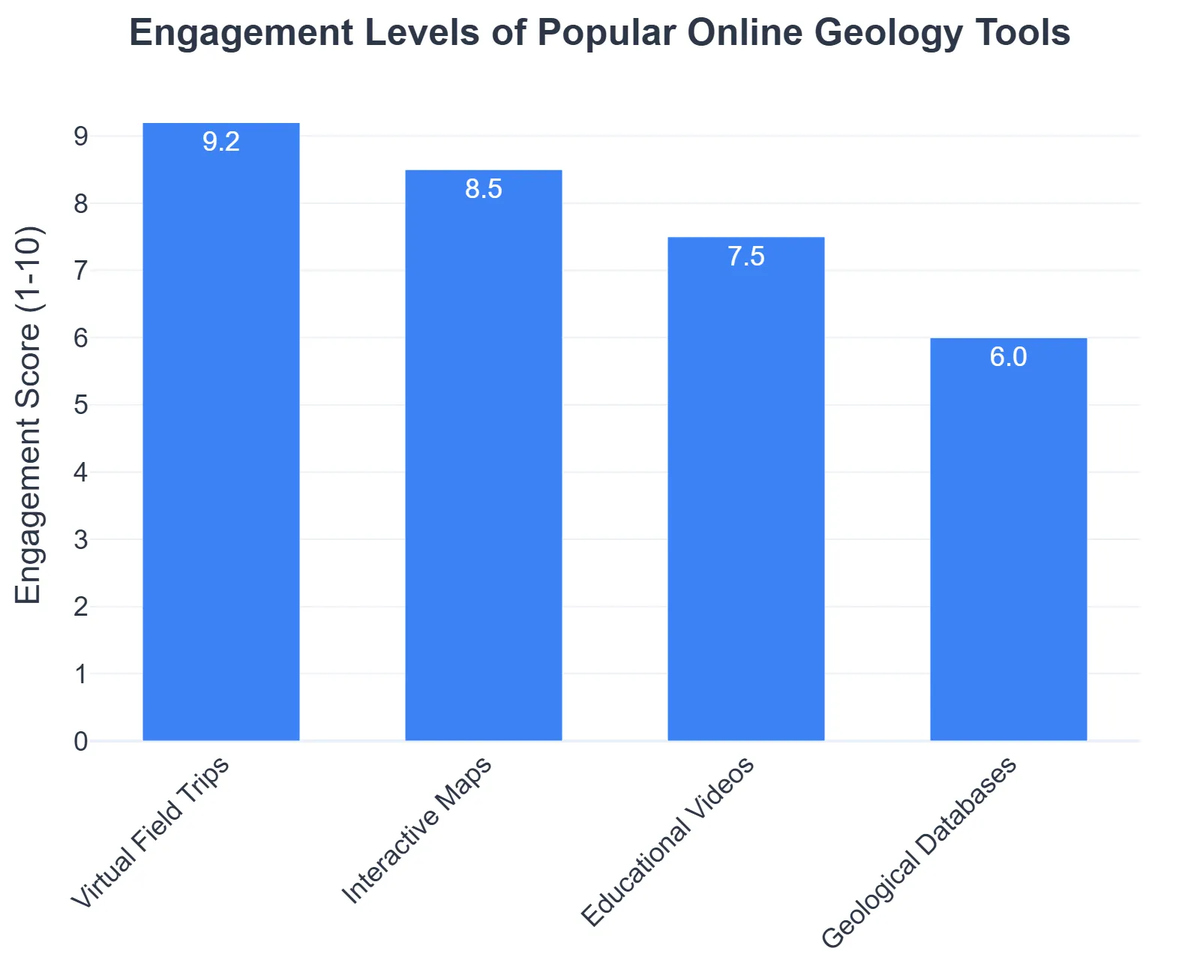
Beyond the Classroom: Virtual Field Trip Platforms
One of the most exciting developments in web geology is the advent of virtual field trip platforms. Traditional geological field trips are essential for hands-on learning but are often limited by cost, logistics, accessibility, and environmental factors. Virtual field trips (VFTs) overcome these barriers by providing immersive, interactive experiences of geological sites from anywhere with an internet connection.
Components of a Virtual Field Trip
A typical VFT platform leverages various technologies to simulate the field experience:
- 360-Degree Panoramas and Videos: High-resolution imagery and video capture the essence of a location, allowing users to “look around” as if they were there.
- 3D Models and Photogrammetry: Digital elevation models, lidar scans, and photogrammetry are used to create detailed 3D models of outcrops, landforms, and even entire landscapes.
- Interactive Hotspots: Clickable points on the virtual environment that provide additional information, such as rock descriptions, geological cross-sections, historical context, or links to relevant research.
- Narrated Tours and Augmented Reality: Guided tours with audio commentary simulate the presence of an expert, while augmented reality (AR) can overlay digital information onto a real-world view (though this is more common in specialized apps than general web platforms).
- Quizzes and Assignments: Educational VFTs often include built-in assessment tools to gauge understanding.
These platforms are invaluable for education, allowing students to “visit” remote or dangerous locations, prepare for actual field trips, or review sites long after a physical visit. They also promote inclusivity, making geological exploration accessible to individuals with mobility constraints or limited resources. Many educational institutions and geological societies now host their own VFTs, covering everything from ancient volcanic fields to glacial landscapes pertinent to soft rock geology. While specific large-scale commercial examples for general use might be limited, many academic initiatives and non-profits, like those supported by the Earth Science Week Online Toolkit or even interactive simulations like those from PhET, demonstrate the power of such virtual learning environments.
Leveraging Web Geology for Research and Education
The applications of web geology extend far beyond simply viewing data; they encompass active research, collaborative projects, and transformative educational methodologies.
GeoLearn Online: Revolutionizing Earth Science Education with Web Geology
❓The Challenge
GeoLearn Online struggled with low student engagement and retention, as their traditional, static content failed to capture the dynamic and data-rich nature of modern Earth science.
💡The Solution
Leveraging the principles of web geology, GeoLearn Online transformed its curriculum by integrating vast online geological databases, enabling real-time data exploration, and deploying interactive 3D models and virtual field trips for immersive learning experiences.
🏆The Result
This digital modernization led to a 40% increase in average student course completion rates and a 25% boost in new course enrollments within the first academic year.
Enhancing Geological Research
- Remote Sensing and Data Analysis: Scientists can analyze satellite imagery, aerial photos, and various sensor data (e.g., thermal, hyperspectral) from anywhere, enabling studies of large-scale geological processes like plate tectonics, volcanic activity, and land deformation.
- Modeling and Simulation: Online platforms and cloud computing enable complex geological modeling, from simulating fluid flow in porous rocks to predicting earthquake magnitudes and tsunami propagation.
- Global Collaboration: Researchers across continents can share data, collaborate on projects, and peer-review findings in real-time, accelerating discovery.
- Citizen Science: Web platforms facilitate citizen science initiatives, allowing the public to contribute to data collection (e.g., reporting earthquake felt reports, identifying rock types in images), broadening the scope of research.
Transforming Geological Education
- Supplementary Learning Materials: Online databases and mapping tools provide rich visual and quantitative data for classroom discussions, assignments, and student projects.
- Accessibility and Inclusivity: Virtual field trips break down barriers, making geological education accessible to a wider audience, including those with physical disabilities or financial constraints.
- Engaging and Interactive Learning: Interactive simulations, 3D models, and virtual reality experiences make complex geological concepts more tangible and engaging for learners of all ages.
- Professional Development: Online courses and webinars leveraging web geology tools provide opportunities for continuous learning and skill enhancement for professionals.
Career Opportunities and Skills in Digital Earth Science
The rise of web geology has opened new career pathways and redefined existing roles within Earth science. Professionals equipped with digital skills are increasingly in demand across various sectors.
Emerging Roles and Required Skills
- Geospatial Analysts/Scientists: Expertise in GIS software, remote sensing data processing, and spatial analysis. These roles are critical in environmental consulting, urban planning, resource management, and disaster preparedness.
- Data Scientists (Geology Focus): Strong statistical skills, programming (e.g., Python, R), machine learning, and the ability to manage and interpret large geological datasets. Applicable in oil and gas, mining, and academic research.
- Geological Software Developers: Engineers who specialize in building web-based geological applications, interactive mapping tools, and data visualization platforms.
- Virtual Field Trip Developers: Professionals combining geological knowledge with 3D modeling, virtual reality (VR), and augmented reality (AR) development skills to create immersive educational experiences.
- Remote Sensing Specialists: Focused on acquiring, processing, and interpreting satellite and aerial imagery for geological mapping, hazard assessment, and environmental monitoring.
For aspiring Earth scientists, developing proficiency in digital tools—from basic spreadsheet software to advanced GIS and programming languages—is no longer optional but essential. Understanding data management, visualization techniques, and online collaboration platforms will be key to navigating the evolving landscape of geological careers.
The Future of Web Geology: AI, VR, and Beyond
The trajectory of web geology is exciting, driven by rapid advancements in artificial intelligence (AI), virtual reality (VR), and augmented reality (AR), alongside the ever-increasing volume of Earth observation data.
- Artificial Intelligence and Machine Learning: AI algorithms are already being used to automate geological mapping, predict mineral occurrences, analyze seismic data for fault detection, and even identify rock types from images. The future will see more sophisticated AI models capable of complex predictive analysis and autonomous data interpretation.
- Immersive VR/AR Experiences: While current virtual field trips are compelling, true VR and AR environments will offer unparalleled immersion, allowing users to “walk through” geological formations, manipulate virtual samples, and conduct simulated experiments within a realistic digital Earth. This will revolutionize both education and professional training.
- Big Data and Cloud Computing: The exponential growth of geological data necessitates robust cloud infrastructure for storage, processing, and analysis. Future web geology platforms will be increasingly cloud-native, offering scalable computing power for even the most demanding simulations.
- Real-time Geospatial Intelligence: Integration of real-time sensor data (e.g., from seismic networks, GPS stations, weather satellites) with web-based mapping tools will enable instantaneous monitoring of geological events, improving disaster response and risk management.
- Open Science and Data Sharing: There will be a continued push towards more open access to geological data and research, fostering greater collaboration and accelerating the pace of discovery globally.
The continuous evolution of these technologies promises to make web geology an even more powerful and indispensable tool for understanding and interacting with our dynamic planet.
Recommended Video
Conclusion
Web geology has fundamentally reshaped how we explore, understand, and interact with Earth science. From robust online geological databases that serve as digital libraries of our planet’s history to intuitive interactive mapping tools that provide dynamic insights into Earth’s processes, and immersive virtual field trip platforms that democratize access to geological wonders, the digital realm has become an indispensable extension of the geologist’s toolkit.
This digital revolution is not just about convenience; it’s about breaking down geographical barriers, accelerating research, enriching education, and fostering global collaboration. As technology continues to advance, particularly in AI and immersive realities, the potential for web geology to deepen our understanding of Earth and address its most pressing challenges will only grow. For anyone involved in Earth science, embracing web geology is no longer a choice but a necessity for staying at the forefront of discovery and innovation.
Frequently Asked Questions
What is Web Geology?
Web Geology refers to the study and exploration of Earth science concepts, data, and phenomena using online resources, digital tools, and internet-based platforms.
How can I explore geology online?
You can explore geology online through interactive maps (like Google Earth), virtual reality field trips, academic databases, online courses, and scientific visualization tools.
Are online geology resources reliable?
Many online geology resources from universities, government agencies (e.g., USGS), and reputable scientific organizations are highly reliable and offer accurate, up-to-date information.
What kind of data can I find in Web Geology?
Web Geology platforms often provide access to satellite imagery, topographic maps, seismic data, climate models, geological surveys, and real-time sensor data.