

Beneath the towering peaks of ancient mountain ranges lies a distinctive, often overlooked, yet profoundly significant geological landscape: the piedmont. Derived from the French “pied de mont,” meaning “foot of the mountain,” these transitional zones serve as the Earth’s natural buffer, mediating between the rugged uplands and the expansive lowlands. Understanding piedmont geology is crucial for anyone seeking to grasp the full spectrum of Earth’s dynamic processes, from mountain building to the subtle sculpting power of erosion.
💡 Key Takeaways
- The Piedmont is a geologically complex region, representing the roots of ancient mountain ranges.
- Its bedrock primarily consists of metamorphic and igneous rocks, indicating intense heat, pressure, and volcanic activity.
- The region’s formation involved multiple tectonic collisions, including the assembly of the supercontinent Pangea.
- Studying Piedmont geology provides critical insights into plate tectonics, erosion, and deep-time climatic shifts.
“The Piedmont isn’t just rolling hills; it’s a testament to deep time, where the echoes of ancient collisions and climatic shifts are etched into every rock, offering vital clues to Earth’s evolving systems.”
— Marcus Sterling, Geophysical Explorer & Climate Dynamics Analyst
Piedmont regions are not merely flat plains at the base of mountains; they are complex terrains shaped by millions of years of geological activity, exhibiting unique rock formations, soil compositions, and hydrological patterns. They tell a story of immense geological uplift, relentless erosion, and the redistribution of Earth’s crustal material. As experts in Earth’s Unseen Forces: The Hidden Dynamics of Our Planet, we’ll delve into the fascinating world of piedmonts, uncovering their formation, characteristics, and ecological importance.
In This Article
- — 💡 Key Takeaways
- → What is Piedmont Geology? Defining the Foothill Landscape
- — 🗺️ Etymology and Geographic Context
- — ⛰️ Key Characteristics of Piedmont Regions
- → The Dynamic Formation of Piedmonts: A Tale of Erosion and Uplift
- — 📈 Mountain Building and Isostasy
- — 🌊 The Role of Weathering and Erosion
- — ➡️ Sediment Transport and Deposition
- → Distinctive Geological Features of Piedmont Regions
- — 🪨 Rock Types: Metamorphic, Igneous, and Sedimentary
- — 💧 Drainage Patterns and River Systems
- — 🌿 Unique Soil Composition
- → Major Piedmont Provinces Around the World
- — 🇺🇸 The North American Piedmont: A Classic Example
- — 🌍 Other Notable Piedmont Regions Globally
- → Studying Piedmont Geology: Tools and Techniques
- — 🗺️ Mapping and Fieldwork
- — 🔬 Geochronology and Structural Analysis
- → Ecological and Economic Significance of Piedmont Areas
- — 🌱 Biodiversity Hotspots
- — 💰 Agricultural and Resource Potential
- → Conclusion
What is Piedmont Geology? Defining the Foothill Landscape
Piedmont geology refers to the study of the geological processes, rock types, and landforms characteristic of these transitional zones located at the base of mountain ranges. These areas typically feature gently rolling hills, dissected plateaus, and mature river systems, contrasting sharply with the steeper gradients and younger topography of the mountains themselves.
🗺️ Etymology and Geographic Context
- ✅ Origin: The term “piedmont” comes from the French phrase “pied de mont,” directly translating to “foot of the mountain.”
- ✅ Location: Geographically, a piedmont is an area of land formed at the base of mountains. It acts as an apron or belt of land separating the mountains from the plains or coastal areas beyond.
- ✅ Examples: The most famous example in North America is the vast Piedmont region stretching along the eastern United States, from New Jersey down to Alabama. Other notable piedmonts exist in Italy, South America, and various other mountainous regions globally.
⛰️ Key Characteristics of Piedmont Regions
While specific features vary by location, several characteristics are common to most piedmonts:
- ➡️ Rolling Topography: Typically characterized by undulating hills and valleys rather than flat plains or sharp peaks.
- ➡️ Mature River Systems: Rivers flowing from the mountains often slow down and widen as they enter the piedmont, depositing sediment and forming alluvial plains.
- ➡️ Ancient Geology: The underlying bedrock is often composed of ancient, highly metamorphosed, and igneous rocks, reflecting deep-seated mountain-building processes.
- ➡️ Thick Regolith: Due to extensive weathering over geological time, piedmonts often have a deep layer of weathered rock and soil known as regolith.
The Dynamic Formation of Piedmonts: A Tale of Erosion and Uplift
The creation of piedmont regions is a long and complex geological process, intrinsically linked to the life cycle of mountain ranges. It involves a delicate balance between the powerful forces of uplift and the relentless agents of erosion.
📈 Mountain Building and Isostasy
Piedmonts originate from periods of intense mountain building, or orogeny. As tectonic plates collide, immense pressure and heat cause Earth’s crust to buckle, fold, and thrust upwards, forming mountain chains. For more on how these massive structures arise, explore our article on Geological Uplift: Raising Mountains and Continents.
- 💡 Orogenic Events: The initial formation of high mountains provides the source material for the subsequent development of a piedmont.
- 💡 Isostatic Rebound: As erosion wears down mountain tops, the reduced weight on the crust can cause the underlying lithosphere to rise, leading to continued, albeit slower, uplift even as the surface is being denuded.
🌊 The Role of Weathering and Erosion
Once mountains are uplifted, they are immediately subjected to weathering and erosion. This is where the raw material for piedmonts truly begins to take shape. For a general overview of these processes, consider our insights on Earth Geology Explained: Dynamic Forces Shaping Our Planet.
- ✅ Physical Weathering: Processes like frost wedging, thermal expansion, and abrasion break down mountain rocks into smaller fragments.
- ✅ Chemical Weathering: Water, acids, and oxygen chemically alter rocks, often leading to the formation of clays and soluble minerals.
- ✅ Transport: Rivers, glaciers, and gravity transport these weathered materials downslope from the mountain fronts.
➡️ Sediment Transport and Deposition
As rivers emerge from the steep mountain valleys onto flatter terrain, their energy decreases, causing them to deposit the vast amounts of sediment they carry. This deposition is a primary mechanism in the formation of piedmont surfaces.
- ✅ Alluvial Fans: At the immediate base of steep mountain fronts, coarser sediments are often deposited in fan-shaped structures known as alluvial fans.
- ✅ Floodplains: Further from the mountain, finer sediments (silts, clays) are deposited by meandering rivers, forming extensive floodplains that contribute to the rolling topography of the piedmont.
- ✅ Erosion Surfaces: Over millions of years, repeated cycles of erosion and deposition can create broad, gently sloping surfaces that characterize the mature piedmont landscape.
Distinctive Geological Features of Piedmont Regions
Piedmonts are geological treasure troves, offering insights into ancient Earth processes through their unique rock assemblages and landforms.
🪨 Rock Types: Metamorphic, Igneous, and Sedimentary
The bedrock of most piedmont regions is typically very old and has undergone significant transformation due to intense pressure and heat associated with mountain building.
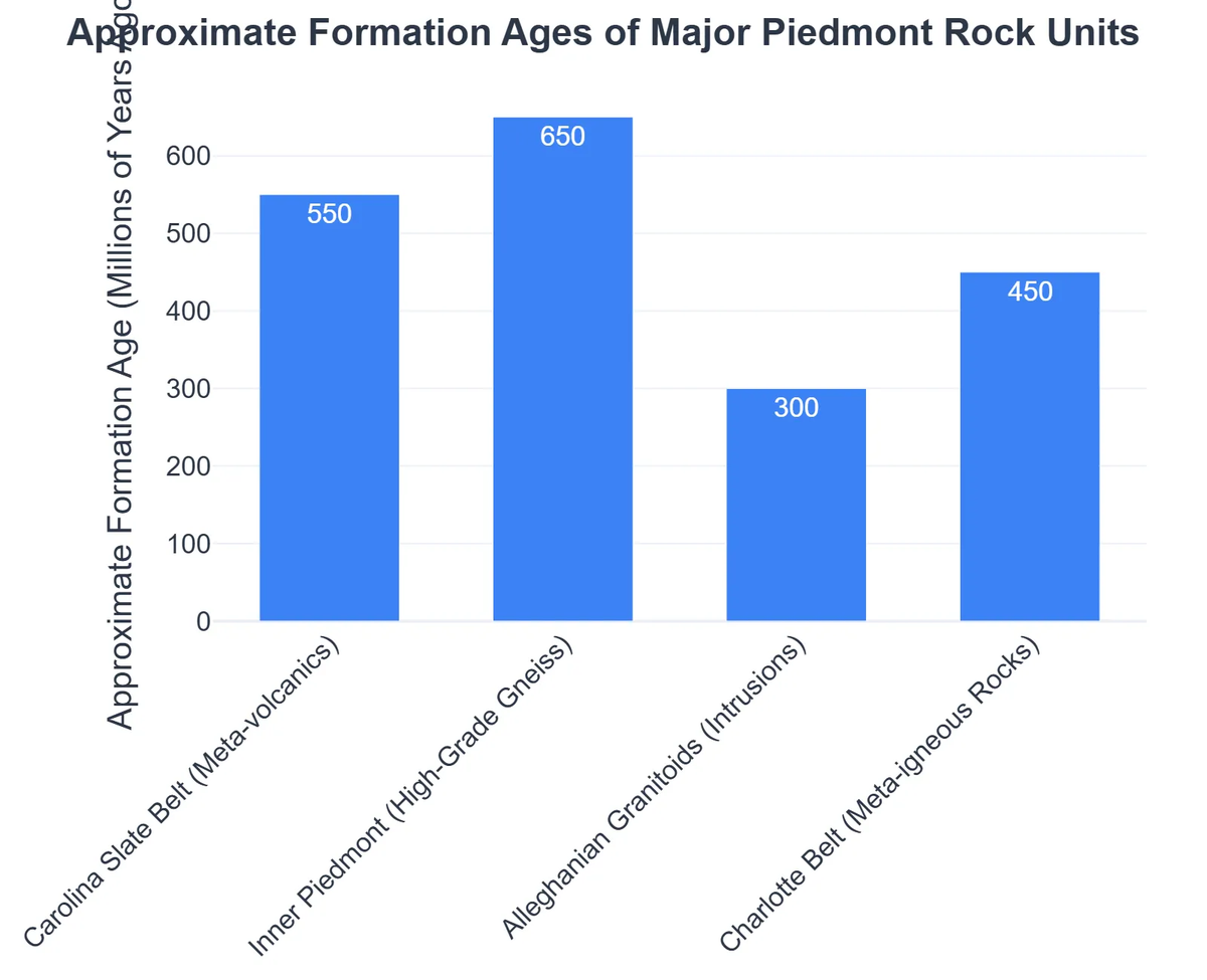
- ✅ Metamorphic Rocks: Dominant types include schists, gneisses, slates, and quartzites. These rocks were originally sedimentary or igneous but were altered by tectonic forces.
- ✅ Igneous Intrusions: Large bodies of granite and other intrusive igneous rocks (like those discussed in Pluton Geology: Exploring Earth’s Deep Igneous Intrusions) are common, representing magma that cooled slowly beneath the ancient mountain ranges.
- ✅ Sedimentary Cover: While the bedrock is often crystalline, younger sedimentary rocks (such as sandstones and shales) might overlie parts of the piedmont, especially near the contact with coastal plains or basins.
💧 Drainage Patterns and River Systems
The hydrology of piedmonts is characterized by mature, often dendritic (tree-like) drainage patterns, indicating uniform resistance to erosion.
- ➡️ Major Rivers: Many large rivers that originate in mountains flow across or through piedmonts before reaching the sea. These rivers are critical for transport and have shaped much of the landscape.
- ➡️ Fall Line: A prominent feature in many piedmonts (e.g., the U.S. East Coast Piedmont) is the “fall line,” where resistant bedrock of the piedmont meets the softer sediments of the coastal plain. This often creates rapids and waterfalls.
🌿 Unique Soil Composition
The long history of weathering of diverse parent materials results in distinctive soil types.
- ✅ Ultisols and Alfisols: These are common soil orders found in humid temperate piedmonts, often characterized by a subsoil accumulation of clay and moderate to strong acidity.
- ✅ Red Clays: The characteristic reddish color of many piedmont soils (e.g., in the southeastern U.S.) comes from the accumulation of iron oxides, a product of extensive chemical weathering.
Major Piedmont Provinces Around the World
While the concept of a piedmont is universal, certain regions stand out as classic examples of this unique geological province.
🇺🇸 The North American Piedmont: A Classic Example
The U.S. Eastern Seaboard boasts one of the most well-studied and economically significant piedmont regions globally. This vast area stretches for hundreds of miles parallel to the Appalachian Mountains.

- 💡 Formation: Formed during the Appalachian Orogenies (e.g., Taconic, Acadian, Alleghenian), which involved multiple collisions and uplift events. The ancient mountain range has since been heavily eroded.
- 💡 Geology: Predominantly composed of highly metamorphosed Precambrian and Paleozoic rocks, with numerous Mesozoic diabase dikes and sills. For instance, the Delaware Piedmont reveals a complex geological history of ancient metamorphic and igneous rocks, as documented by The Delaware Geological Survey.
- 💡 Regions: States like Virginia and North Carolina have significant piedmont sections, characterized by their rolling hills and historical agricultural significance. The Virginia Museum of History & Culture provides insight into this region’s historical and geographical context.
🌍 Other Notable Piedmont Regions Globally
- ➡️ Piedmont, Italy: The region of Piemonte in northern Italy is a classic example, nestled at the foot of the Alps.
- ➡️ Andean Piedmont: Along the eastern flank of the Andes Mountains in South America, vast piedmont plains extend into the Amazon basin, characterized by significant alluvial fan systems.
- ➡️ Rocky Mountain Piedmont: In North America, similar piedmont characteristics can be observed along the eastern foothills of the Rocky Mountains, albeit with different climatic and erosional dynamics.
Studying Piedmont Geology: Tools and Techniques
Geologists employ a variety of methods to unravel the complex history and composition of piedmont regions.
🗺️ Mapping and Fieldwork
The foundation of understanding any geological area lies in meticulous fieldwork and mapping.
- ✅ Regional Geological Maps: These essential tools provide an overview of rock types, structural features, and historical geological events. Interpreting them is critical for identifying potential resources or hazards.
- ✅ Field Geology Guides: Accompanying maps, these guides offer detailed descriptions of outcrops, sample collection techniques, and local geological context, vital for hands-on learning and research.
- ✅ Remote Sensing: Satellite imagery and aerial photography provide broad perspectives on landforms, drainage patterns, and vegetation, which can infer underlying geology.
🔬 Geochronology and Structural Analysis
To understand the timing and deformation of piedmont rocks, advanced techniques are often employed.
- ➡️ Radiometric Dating: Analyzing radioactive isotopes in igneous and metamorphic rocks helps determine their absolute ages, providing a timeline for mountain-building events.
- ➡️ Structural Mapping: Detailed analysis of folds, faults, and foliation in rocks reveals the direction and intensity of past tectonic stresses.
- ➡️ Seismic Surveys: In some areas, seismic waves can be used to image subsurface rock layers, particularly where there is a sedimentary cover.
Ecological and Economic Significance of Piedmont Areas
Beyond their geological interest, piedmont regions are vital ecological and economic zones.
🌱 Biodiversity Hotspots
The varied topography, soil types, and hydrological features create diverse habitats.
- ✅ Transitional Ecosystems: Piedmonts often support unique flora and fauna adapted to conditions between mountains and lowlands.
- ✅ Water Resources: Major rivers flowing through piedmonts are critical sources of fresh water for human consumption, agriculture, and industry.
💰 Agricultural and Resource Potential
The fertile soils and moderate climate make many piedmonts highly productive.
- ➡️ Agriculture: Historically, piedmonts have been significant agricultural areas, supporting crops like cotton, tobacco, and various grains.
- ➡️ Mineral Resources: Some piedmonts contain economically viable deposits of building materials (granite, crushed stone), clays, and historically, even some precious metals.
- ➡️ Hydropower: The ‘fall line’ in many piedmonts has historically been a significant site for hydropower generation and industrial development.
Recommended Video
Conclusion
Piedmont geology offers a compelling narrative of Earth’s relentless forces – from the dramatic upheaval of mountain ranges to the patient, persistent work of erosion. These ancient foothill landscapes are more than just transitional zones; they are distinct geological provinces with unique rock types, landforms, and ecological significance.
By studying piedmonts, geologists gain critical insights into the long-term evolution of continents, the interplay between tectonic forces and surface processes, and the distribution of natural resources. They serve as a testament to the continuous, dynamic transformation of our planet, showcasing how immense pressure and time can sculpt landscapes of profound beauty and practical value.
Frequently Asked Questions
What defines the Piedmont geological region?
The Piedmont is a physiographic province located east of the Blue Ridge Mountains, characterized by rolling hills, shallow valleys, and ancient, highly metamorphosed and igneous bedrock, representing the eroded roots of former mountain ranges.
How did the Piedmont form?
The Piedmont formed over hundreds of millions of years through successive episodes of tectonic plate collisions, particularly during the assembly of the supercontinent Pangea. These collisions caused immense folding, faulting, and metamorphism of rocks, followed by extensive erosion.
What types of rocks are commonly found in the Piedmont?
Common rock types in the Piedmont include various metamorphic rocks like schist, gneiss, slate, and phyllite, as well as igneous rocks such as granite and gabbro, which are remnants of ancient volcanic and intrusive activity.
Why is the geology of the Piedmont important?
Studying Piedmont geology is crucial for understanding the history of continental collisions, the dynamics of plate tectonics, the formation of mineral resources, and how landscapes evolve over vast geological timescales under the influence of climate and erosion.