

Surficial Geology: Unearthing Earth’s Top Layer Secrets
The Earth beneath our feet is far more dynamic and intricate than most realize. While popular imagination often gravitates towards molten cores and ancient bedrock, it’s the uppermost, relatively unconsolidated layer that dictates much of our daily lives. This is the realm of surficial geology – the scientific study of the unconsolidated materials at Earth’s surface, formed by processes active in the Quaternary Period and extending to the present day.
💡 Key Takeaways
- Surficial geology focuses on the Earth’s dynamic outermost layer, including unconsolidated materials like sediments and soils.
- It encompasses the study of landforms, superficial deposits, and the geomorphic processes that shape the landscape.
- Understanding surficial geology is crucial for land-use planning, natural hazard assessment, resource management, and environmental protection.
- This field provides vital insights into past climate changes and their ongoing impact on the Earth’s surface environments.
“Surficial geology isn’t just about dirt and rocks; it’s the living, breathing skin of our planet, directly reflecting the interplay of climate, tectonics, and life over geological timescales. It’s where the most dynamic environmental changes manifest.”
— Marcus Sterling, Geophysical Explorer & Climate Dynamics Analyst
From the fertile soils that feed us to the stable ground we build upon, the secrets held within Earth’s top layer are critical for understanding our environment, mitigating natural hazards, and managing vital resources. This comprehensive guide will unearth the fascinating world of surficial geology, revealing its fundamental concepts, critical importance, and the cutting-edge techniques used to decode its mysteries.
In This Article
- → Surficial Geology: Unearthing Earth’s Top Layer Secrets
- — 💡 Key Takeaways
- → What is Surficial Geology? The Earth’s Dynamic Skin
- — Defining the Top Layer
- — Key Components of Surficial Geology
- → Processes Shaping the Surface: Weathering, Erosion, and Deposition
- — 🌧️ Weathering: Breaking Down the Earth
- — 🌬️ Erosion: Moving the Pieces
- — 💧 Deposition: Laying Down New Layers
- → The Importance of Surficial Geology: Why it Matters
- — 🚜 Agriculture and Soil Science
- — 🏗️ Engineering and Construction
- — 🌍 Environmental Management
- — 🔎 Natural Resource Exploration
- → Tools and Techniques in Surficial Geology
- — 🗺️ Geological Mapping and GIS
- — 🔬 Laboratory Analysis
- — 🛰️ Remote Sensing
- → Case Studies and Real-World Applications
- — Mitigating Geohazards
- — Groundwater Resource Management
- — Understanding Climate Change Impacts
- → The Future of Surficial Geology: Facing New Challenges
- — Addressing Anthropogenic Impacts
- — Advanced Data Integration
- → Conclusion
What is Surficial Geology? The Earth’s Dynamic Skin

Surficial geology is a specialized branch of geology focused on the materials and processes occurring at or near the Earth’s surface. Unlike bedrock geology, which deals with solid, older rock formations, surficial geology investigates the younger, looser sediments, soils, and landforms that have been deposited, eroded, or altered by various environmental forces.
Defining the Top Layer
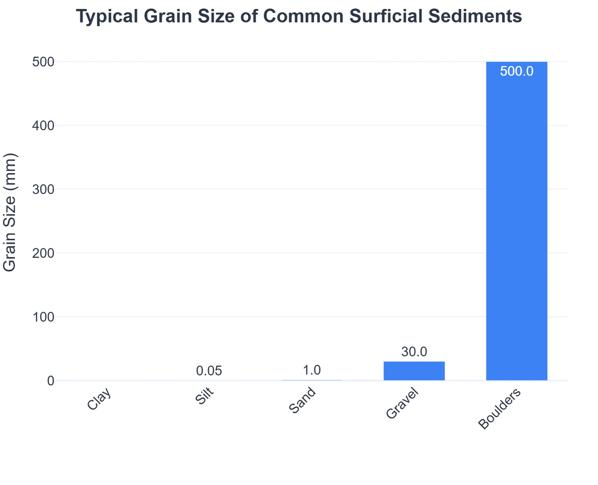
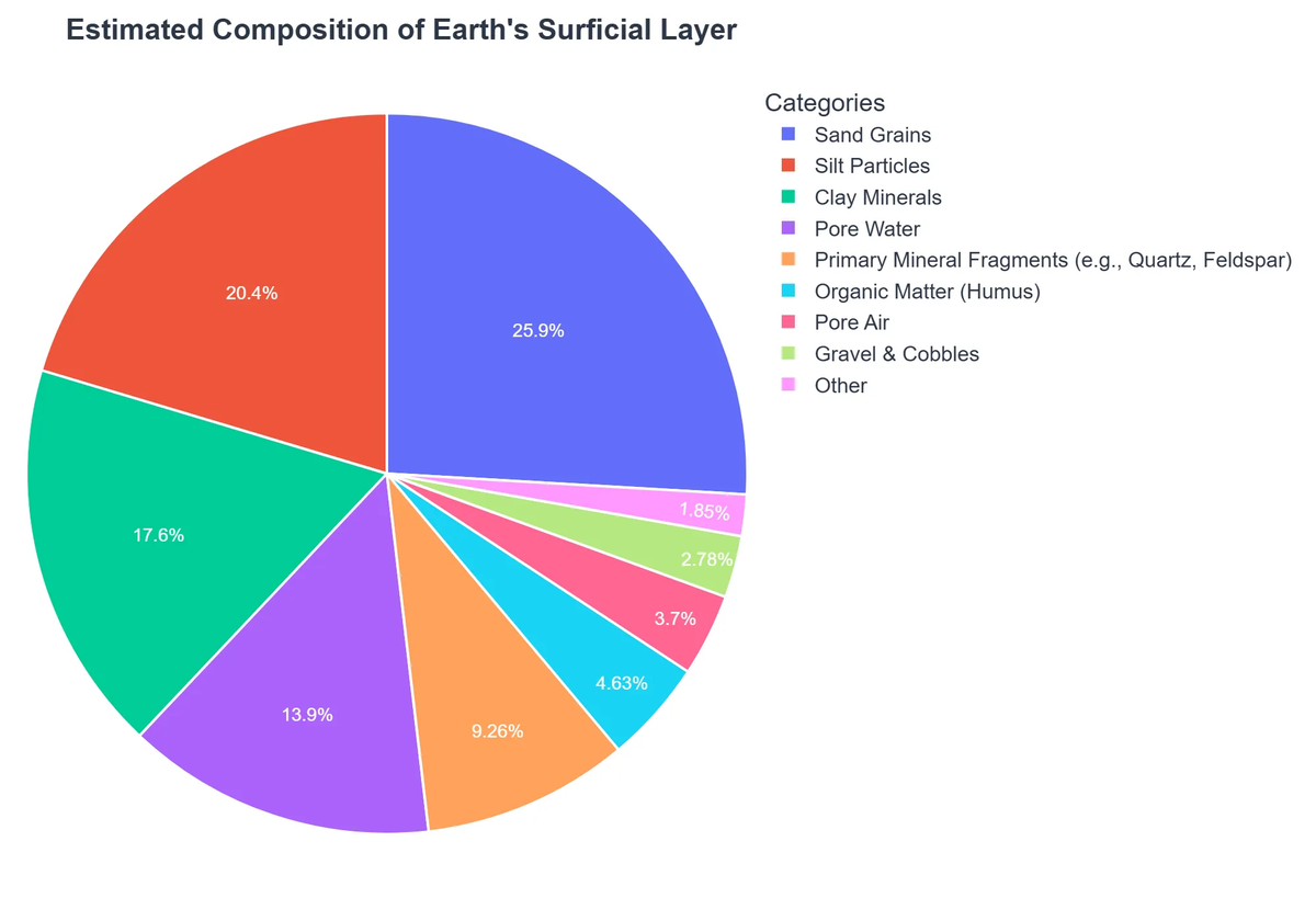
- ✅ Unconsolidated Materials: This includes everything from loose sand, gravel, and clay to peat, till, and alluvium. These materials are often derived from the weathering and erosion of underlying bedrock.
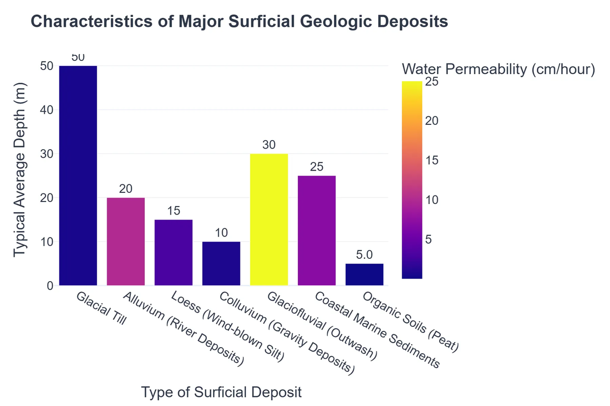
- ✅ Quaternary Focus: While not exclusively limited, surficial geology often emphasizes deposits from the Quaternary Period (the last 2.6 million years), which includes glacial, fluvial, eolian, and coastal processes.
- ✅ Dynamic Processes: It’s not just about the materials themselves, but also the ongoing processes that shape them, such as weathering, erosion, deposition, and mass movement.
Key Components of Surficial Geology
The field encompasses a diverse range of Earth materials and features:
- ➡️ Soils: The uppermost layer of Earth’s crust, supporting plant growth, formed by weathering of rock and decay of organic matter.
- ➡️ Sediments: Loose particles of rock, mineral, or organic material transported and deposited by wind, water, or ice.
- ➡️ Landforms: Natural features of the Earth’s surface, such as dunes, deltas, moraines, river terraces, and floodplains, shaped by surficial processes.
- ➡️ Groundwater: The water found beneath the Earth’s surface in aquifers, significantly influenced by the permeability and porosity of surficial deposits.
Processes Shaping the Surface: Weathering, Erosion, and Deposition
The Earth’s surface is in a constant state of flux, sculpted by an intricate dance of destructive and constructive forces. Understanding these fundamental processes is at the core of surficial geology.
🌧️ Weathering: Breaking Down the Earth
Weathering is the in-situ (on-site) breakdown of rocks and minerals at or near the Earth’s surface. It can be physical (mechanical) or chemical:
- Physical Weathering: Processes like freeze-thaw cycles, exfoliation, root wedging, and abrasion break rocks into smaller pieces without changing their chemical composition.
- Chemical Weathering: Involves chemical reactions that alter the composition of minerals, such as dissolution, oxidation, and hydrolysis. This process is crucial for soil formation.
🌬️ Erosion: Moving the Pieces
Erosion is the process by which Earth’s surface is worn away by the action of wind, water, ice, and gravity, transporting weathered material from one location to another.
- Fluvial Erosion: The action of flowing water (rivers, streams) carving out valleys and transporting sediments.
- Eolian Erosion: The removal and transport of sediment by wind, common in arid and semi-arid regions, forming dunes.
- Glacial Erosion: The powerful force of moving ice (glaciers) carving out U-shaped valleys and transporting vast quantities of till.
- Mass Movement (Gravity): Processes like landslides, mudflows, and rockfalls, where gravity directly pulls material downslope.
💧 Deposition: Laying Down New Layers
Deposition occurs when agents of erosion lose energy and drop their transported load, accumulating sediments in new locations. These deposits often form distinctive landforms.
- Fluvial Deposits: Alluvium in floodplains, deltas, and riverbeds.
- Eolian Deposits: Sand dunes and loess deposits (wind-blown silt).
- Glacial Deposits: Moraines, eskers, kames, and outwash plains, composed of unsorted till and sorted glaciofluvial sediments.
- Lacustrine & Marine Deposits: Sediments accumulating in lakes and oceans, respectively.
The Importance of Surficial Geology: Why it Matters
Understanding surficial geology is far from an academic exercise; it has profound practical implications for human societies and the environment.
Surficial Geology: Benefits and Challenges
Pros
- ✔Essential for natural hazard assessment and mitigation (e.g., landslides, floods).
- ✔Crucial for groundwater exploration, management, and water quality protection.
- ✔Informs environmental site assessment, remediation, and soil conservation efforts.
- ✔Provides vital data for land-use planning, agriculture, and civil engineering projects.
Cons
- ✖Data acquisition can be time-consuming, labor-intensive, and expensive.
- ✖Interpretation is complex due to the highly variable and dynamic nature of surficial deposits.
- ✖Fieldwork is often challenging, limited by accessibility in remote or difficult terrains.
- ✖Predictions based on surficial data can carry significant uncertainties due to natural variability.
🚜 Agriculture and Soil Science
The composition and properties of surficial materials directly influence soil fertility, drainage, and agricultural productivity. Geologists work alongside agronomists to map soil types, assess nutrient content, and understand erosion potential. For farmers and land managers, conducting precise soil testing kits are indispensable for optimizing crop yields and ensuring sustainable land use.
🏗️ Engineering and Construction
Before any major construction project—be it a skyscraper, a road, or a dam—a thorough understanding of the underlying surficial geology is paramount. The stability, bearing capacity, and permeability of the top layers dictate foundation design, excavation methods, and potential geohazards. Geologists use techniques like assessing rock quality to inform engineering decisions, as detailed in discussions on RQD in Geology: Assessing Rock Quality for Engineering.
🌍 Environmental Management
Surficial geology plays a crucial role in environmental protection and resource management. It helps in locating and protecting groundwater resources, understanding pollutant pathways in soil and water, and assessing the risks of natural hazards like landslides and flooding. Many projects require comprehensive environmental site assessment services to evaluate the impact of human activity on the land, especially as we grapple with defining new geological epochs like the Anthropocene, shaped by human influence.
How ‘TerraForm Developments’ Reduced Project Delays by 25%
❓The Challenge
TerraForm Developments experienced frequent, costly delays in their residential and commercial projects due to unexpected ground instability and poor drainage, leading to significant budget overruns.
💡The Solution
By rigorously applying surficial geology principles to their pre-construction site assessments, TerraForm Developments gained a comprehensive understanding of the Earth’s top layer. They meticulously analyzed unconsolidated materials, groundwater dynamics, and landform characteristics to predict ground behavior and potential hazards more accurately.
🏆The Result
This proactive geological insight led to a 25% reduction in project delays caused by unforeseen ground conditions and an impressive 30% decrease in foundation-related remediation costs.
🔎 Natural Resource Exploration
While often associated with bedrock, surficial geology is also vital for exploring and managing certain natural resources. Placer deposits (e.g., gold, diamonds), sand and gravel for construction, and even certain types of groundwater are directly related to surficial processes and deposits.
Tools and Techniques in Surficial Geology
Modern surficial geologists employ a blend of traditional field methods and cutting-edge technologies to analyze and interpret Earth’s top layer.
🗺️ Geological Mapping and GIS
At the heart of surficial geology is detailed mapping. Geologists traverse terrain, identifying and logging different surficial units. This data is increasingly integrated into Geographic Information Systems (GIS) using advanced geological mapping software (e.g., ArcGIS, QGIS). GIS allows for the creation of intricate maps that display distribution of materials, landforms, and even subsurface conditions, enabling powerful spatial analysis.
🔬 Laboratory Analysis
Samples collected in the field undergo rigorous laboratory analysis. Techniques include:
- 💡 Grain Size Analysis: Determining the proportion of sand, silt, and clay.
- 💡 Mineralogical Analysis: Identifying the mineral composition of sediments using X-ray diffraction or petrographic microscopy.
- 💡 Geochemical Analysis: Measuring the chemical elements present, crucial for understanding soil fertility or contamination.
- 💡 Dating Techniques: Radiocarbon dating, optically stimulated luminescence (OSL), and cosmogenic nuclide dating to determine the age of deposits and landforms.
🛰️ Remote Sensing
Satellite imagery, aerial photographs, and LiDAR (Light Detection and Ranging) provide invaluable data for surficial geologists. These remote sensing techniques allow for large-scale analysis of landforms, vegetation patterns, and even subtle changes in topography, which can indicate underlying geological structures or processes.
Case Studies and Real-World Applications
The principles of surficial geology are applied daily across various sectors, solving complex challenges.
Mitigating Geohazards
Understanding the distribution and properties of unconsolidated materials is crucial for assessing and mitigating risks from geohazards. For instance, detailed surficial maps can identify areas prone to landslides or liquefaction during earthquakes. Effective hazard mitigation often involves the practical application of geological knowledge, as discussed in detail in our article on Applied Geology: Solving Real-World Challenges.
Groundwater Resource Management
The availability and quality of groundwater are heavily dependent on surficial deposits, which act as aquifers or aquitards. Geologists use surficial maps to delineate aquifer boundaries, estimate recharge rates, and model contaminant transport, ensuring sustainable water supplies.
Understanding Climate Change Impacts
Surficial geology is a powerful tool for reconstructing past climates and predicting future environmental changes. By studying ancient glacial deposits, lake sediments, and coastal landforms, geologists can piece together Earth’s climatic history, providing context for current global warming trends. The dynamic interaction between human activities and the planet’s surface is a key area of interest for Earth’s Unseen Forces: The Hidden Dynamics of Our Planet.
The Future of Surficial Geology: Facing New Challenges
As human populations grow and climate change intensifies, the role of surficial geology becomes ever more critical. The field is continuously evolving to meet new demands.
Addressing Anthropogenic Impacts
The human footprint on Earth’s surface is undeniable. Surficial geologists are increasingly focused on understanding the impact of urbanization, deforestation, mining, and waste disposal on land stability, water quality, and ecosystems. This often involves detailed environmental site assessments to quantify and mitigate these impacts.
Advanced Data Integration
The future of surficial geology lies in the integration of vast datasets—from drone-based LiDAR to continuous seismic monitoring—with advanced computational models. This will allow for more precise predictions of natural hazards, more efficient resource management, and a deeper understanding of the complex interactions between Earth’s surface and human activity.
Recommended Video
Conclusion
Surficial geology is far more than just dirt and rocks; it’s the dynamic interface where geological processes meet human civilization. By studying Earth’s top layer, we gain invaluable insights into the processes that shape our landscapes, influence our resources, and pose potential hazards. As our planet continues to change, driven by both natural forces and human activity, the expertise of surficial geologists will remain indispensable for building resilient communities and safeguarding our environment. Understanding these hidden dynamics is key to navigating the complex challenges of our planet’s future.
Frequently Asked Questions
What is surficial geology?
Surficial geology is the study of the Earth’s unconsolidated materials (like sediments, soils, and regolith) and the geological processes that shape the land surface, such as erosion, deposition, and weathering.
Why is surficial geology important?
It is crucial for understanding natural hazards (landslides, floods), groundwater resources, land-use planning, agricultural productivity, and the impacts of climate change on landscapes and ecosystems.
What types of materials does surficial geology study?
It studies materials like sand, gravel, clay, silt, till (glacial deposits), loess (wind-blown silt), organic deposits, and colluvium found on or near the Earth’s surface.
How does climate change relate to surficial geology?
Climate change directly influences surficial processes by altering precipitation patterns, increasing permafrost thaw, affecting glacial melt rates, and changing river and coastal dynamics, leading to significant landscape modifications.