

Rivers are more than just flowing water; they are dynamic geological agents, relentlessly shaping the Earth’s surface. The study of river geology, also known as fluvial geomorphology, delves into how these natural waterways erode, transport, and deposit sediment, creating an astonishing array of landforms and influencing ecosystems across the globe.
💡 Key Takeaways
- Rivers are primary sculptors of Earth’s topography, driving significant landscape change.
- Sediment transport is a complex process influenced by river velocity, bed material, and gradient.
- Fluvial processes create diverse landforms like deltas, floodplains, and meanders.
- Understanding river geology is crucial for managing water resources and predicting environmental changes.
“Rivers are Earth’s circulatory system, not just conduits for water but relentless sculptors of geology. Their sediment transport mechanisms profoundly dictate planetary surface evolution, reflecting deep-time climate and tectonic shifts.”
— Marcus Sterling, Geophysical Explorer & Climate Dynamics Analyst
From the intricate branching patterns of tributaries to the vast deltas where rivers meet the sea, every aspect of a river’s journey is a testament to the powerful, hidden dynamics of our planet. Understanding the geology of rivers is crucial not only for scientific insight but also for managing water resources, predicting natural hazards, and appreciating the intricate interplay of forces that define our world.
In This Article
- — 💡 Key Takeaways
- → The Fundamentals of River Systems
- — 📚 What is Fluvial Geomorphology?
- — 🌊 The Anatomy of a River: From Source to Mouth
- — 🗺️ Understanding Drainage Basins and Divides
- → Erosional Processes: Rivers as Sculptors of Land
- — 💧 Hydraulic Action and Abrasion
- — 🧪 Attrition and Solution
- — 📈 Types of Erosion: Vertical, Lateral, and Headward
- → Sediment Transport: The River’s Dynamic Load
- — ⚖️ Dissolved, Suspended, and Bed Load
- — ⚙️ Mechanisms of Transport: Traction, Saltation, Suspension
- — 📊 Factors Influencing Sediment Transport
- → Deposition and Landform Creation
- — 🏞️ Alluvial Rivers vs. Bedrock Rivers
- — 🌾 Formation of Floodplains and Levees
- — 🔄 Meanders, Oxbow Lakes, and Braided Channels
- — 🏞️ Deltas and Alluvial Fans
- → The Influence of Geology on River Morphology
- — 🏔️ Rock Type and Structural Control
- — tectonic Activity and River Rejuvenation
- → The Environmental Significance of River Geology
- — 🌳 River Health and Ecosystems
- — 🏙️ Human Impact and River Management
- → Conclusion
The Fundamentals of River Systems
At its core, river geology explores the physical processes and landforms associated with flowing water. This field integrates principles from hydrology, sedimentology, and geomorphology to provide a comprehensive understanding of riverine environments.
📚 What is Fluvial Geomorphology?
Fluvial geomorphology is the scientific study of the landforms created by the action of moving water, primarily rivers and streams. It examines the processes of erosion, transport, and deposition that shape river channels, floodplains, and entire drainage basins. This discipline helps us decipher the history of landscapes and predict their future evolution.

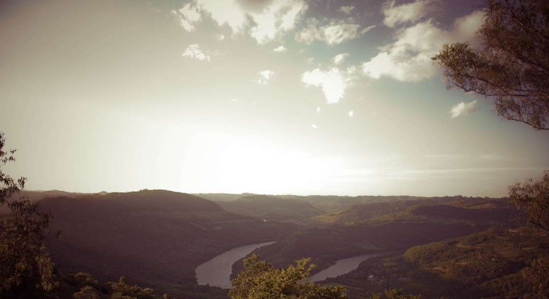
🌊 The Anatomy of a River: From Source to Mouth
A river system can be conceptualized as a continuous entity with distinct zones, each characterized by different dominant processes:
- Upper Course (Zone of Erosion): Typically found in mountainous or elevated regions, characterized by steep gradients, high velocity, and active downcutting. Valleys are often V-shaped.
- Middle Course (Zone of Transport and Erosion): Here, the gradient lessens, and the river begins to widen its valley. Both erosion and deposition occur, leading to the formation of meanders.
- Lower Course (Zone of Deposition): Characterized by gentle gradients, slow velocity, and significant deposition. Wide floodplains, deltas, and often a broad, shallow channel are common.
The journey from source to mouth sees a continuous transformation in the river’s energy, sediment load, and geomorphic work.
🗺️ Understanding Drainage Basins and Divides
Every river exists within a larger system called a drainage basin (or watershed). This is the entire area of land where all the precipitation that falls eventually drains into a common outlet, such as a river, lake, or ocean. Drainage basins are separated by drainage divides, which are elevated ridges of land that determine the direction of water flow.
The morphology of drainage basins, including their shape, size, and underlying geology, profoundly influences the characteristics of the rivers within them. For instance, the way tributaries merge to form larger rivers often follows specific patterns, such as the Dendritic Patterns in Geology: Nature’s Branching Designs, which are influenced by bedrock structure.
Erosional Processes: Rivers as Sculptors of Land
Rivers are powerful agents of erosion, constantly carving out valleys and shaping landscapes. This erosional work occurs through several distinct processes, all driven by the energy of the flowing water and its sediment load.
💧 Hydraulic Action and Abrasion
- Hydraulic Action: This is the sheer force of the moving water. The turbulent flow, particularly during floods, can dislodge loose material from the riverbed and banks. Air trapped in cracks can also be compressed by the water, then expand, breaking apart rock.
- Abrasion (Corrasion): This is the “sandpaper” effect. Sediment carried by the river grinds and scrapes against the bed and banks, wearing them away. The effectiveness of abrasion depends on the quantity, size, and hardness of the sediment load, as well as the velocity of the water.
🧪 Attrition and Solution
- Attrition: As sediment particles are transported downstream, they collide with each other and the riverbed. These collisions cause the particles to break down, become smaller, and more rounded. This process reduces the overall size of the sediment load.
- Solution (Corrosion): Certain rocks, particularly soluble ones like limestone, can be dissolved by the slightly acidic river water. This process is less visible but contributes significantly to landscape modification in areas with susceptible geology.
📈 Types of Erosion: Vertical, Lateral, and Headward
Rivers erode in different directions, leading to distinct landform development:
- Vertical Erosion (Downcutting): Dominant in the upper course, this is the deepening of the river channel, often creating V-shaped valleys and gorges.
- Lateral Erosion: Predominant in the middle and lower courses, this involves the widening of the river valley as the river attacks its banks. This is crucial for the formation of meanders and floodplains.
- Headward Erosion: This is the extension of the river channel upstream, often occurring at the source through processes like gully erosion and spring sapping. It effectively lengthens the river system over time.
Sediment Transport: The River’s Dynamic Load
Once eroded, material becomes part of the river’s sediment load. The ability of a river to transport this material is fundamental to its role in shaping landforms. The type and amount of sediment transported depend heavily on the river’s energy and discharge.
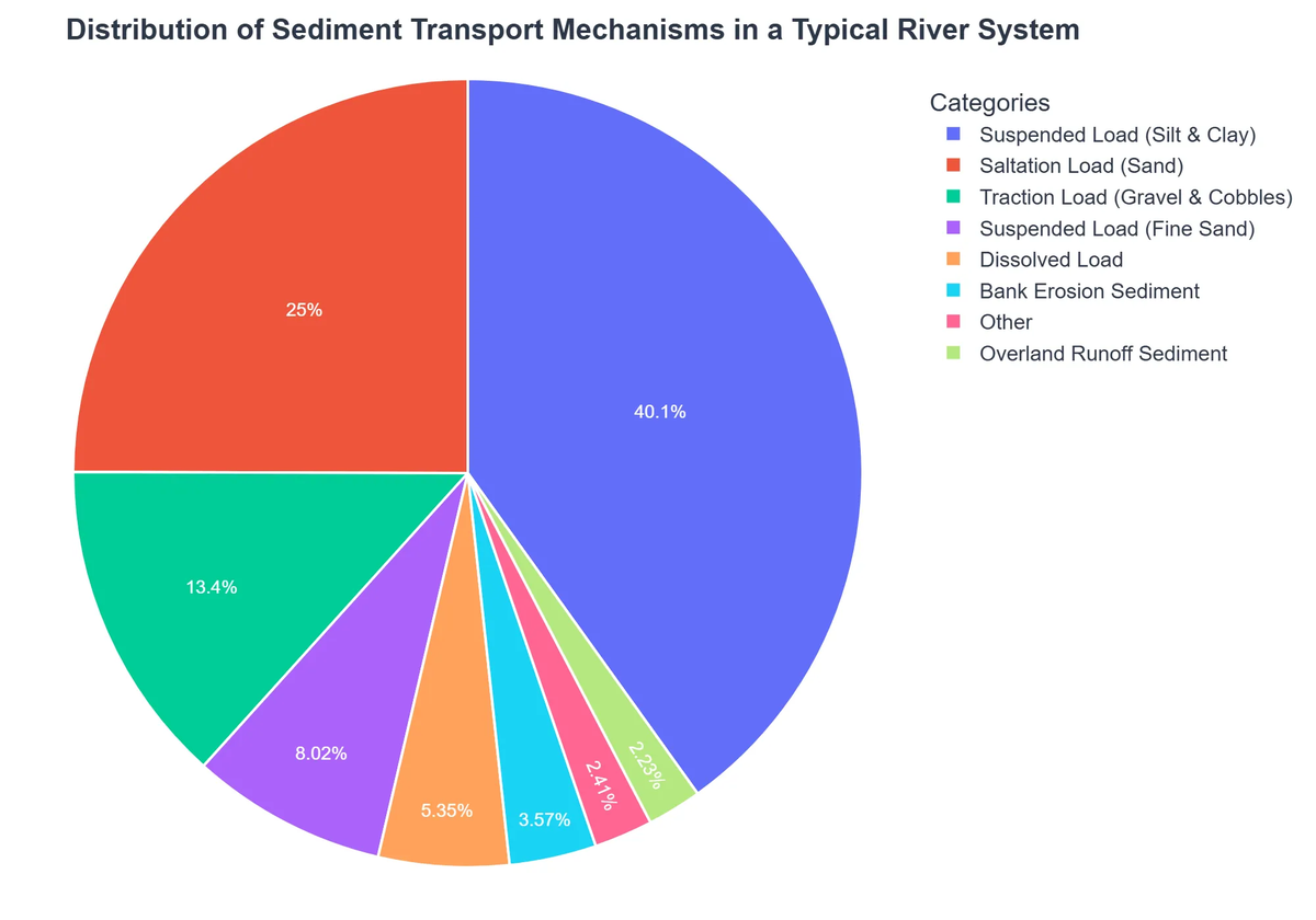
⚖️ Dissolved, Suspended, and Bed Load
Sediment is transported in different ways, categorized by how it interacts with the water:
River Geology: Landscape Shaping and Sediment Transport – Pros and Cons
Pros
- ✔Creates fertile floodplains and diverse landscapes.
- ✔Essential for the global nutrient and sediment cycle.
- ✔Provides valuable geological resources like sand and gravel.
- ✔Offers insights into Earth’s geological history and climate change.
Cons
- ✖Potential for destructive flooding and erosion, threatening infrastructure.
- ✖Sedimentation can clog waterways, impact navigation, and reduce reservoir capacity.
- ✖Acts as a conduit for the transport and dispersion of pollutants.
- ✖Complex dynamics make precise long-term predictions challenging.
- Dissolved Load: Chemical ions dissolved in the water from soluble rocks. This load is invisible and is carried within the water itself.
- Suspended Load: Fine particles (silt, clay, fine sand) held in suspension by the turbulence of the water. This is what gives many rivers their murky appearance.
- Bed Load: Larger, heavier particles (sand, gravel, pebbles, boulders) that move along the riverbed.
⚙️ Mechanisms of Transport: Traction, Saltation, Suspension
The bed load moves through distinct mechanisms:
- Traction: The largest, heaviest particles are rolled or slid along the riverbed by the force of the water.
- Saltation: Medium-sized particles are bounced or hopped along the bed, lifted by the current and falling back down.
- Suspension: Fine particles are carried within the water column without touching the bed for extended periods. This is often the largest component of a river’s sediment load, especially during high flow events. Research further elaborates on the role of seasonal sediment transport in shaping riverbeds, highlighting its dynamic nature. See this study on The Role of Seasonal Sediment Transport and Sintering in Shaping Riverbeds.
📊 Factors Influencing Sediment Transport
Several factors dictate how much and what type of sediment a river can transport:
- Velocity: Faster water can carry more and larger sediment.
- Discharge: The volume of water flowing per unit time. Higher discharge generally means higher energy and greater transport capacity.
- Gradient: Steeper slopes lead to higher velocities and increased transport.
- Sediment Size and Shape: Smaller, rounder particles are easier to transport.
- Vegetation: Bankside vegetation can stabilize banks and reduce sediment input.
- Geology of the Drainage Basin: The type of bedrock and regolith influences the availability of sediment. Learn more about Regolith in Geology: Soil Formation and Planetary Surfaces.
Deposition and Landform Creation
When a river’s energy decreases, it loses its capacity to carry its sediment load, leading to deposition. This process is responsible for building many of the characteristic landforms found along river valleys and at their mouths.
🏞️ Alluvial Rivers vs. Bedrock Rivers
River channels can broadly be classified based on the material of their bed:
- Alluvial Rivers: These rivers flow over beds composed of their own deposited sediment (alluvium). Their channels are easily reshaped by flow, leading to features like meanders and braided channels.
- Bedrock Rivers: These rivers flow directly over solid rock. Erosion primarily occurs through abrasion and hydraulic action, often forming bedrock gorges and rapids. Understanding Bedrock Geology: Earth’s Unseen Foundation is crucial for comprehending these river types. Further insights can be found in guides like Understanding Bedrock Rivers.
🌾 Formation of Floodplains and Levees
- Floodplains: Flat, wide areas adjacent to river channels, built up by the deposition of fine sediments (silt, clay) during floods. When a river overflows its banks, the water loses velocity and drops its suspended load, enriching the soil.
- Natural Levees: Raised banks on either side of the river channel, formed during floods. As floodwaters spill over the banks, the coarsest, heaviest sediment is deposited immediately, building up natural embankments.
🔄 Meanders, Oxbow Lakes, and Braided Channels
The morphology of river channels is incredibly diverse:
- Meanders: Sinuous, winding bends in a river’s course, formed by a combination of erosion on the outside bend (cut bank) and deposition on the inside bend (point bar). This process continuously shifts the river’s path across its floodplain.
- Oxbow Lakes: Crescent-shaped lakes formed when a meander bend is cut off from the main river channel during a flood, as the river finds a straighter path.
- Braided Channels: Wide, shallow channels divided into multiple smaller channels by bars of deposited sediment. These typically form in rivers with a high sediment load, variable discharge, and easily erodible banks.
🏞️ Deltas and Alluvial Fans
- Deltas: Landforms created at the mouth of a river where it enters a larger body of water (ocean, lake, or another river). As the river’s velocity decreases sharply, its sediment load is deposited, building up new land in characteristic shapes (e.g., bird’s foot, arcuate).
- Alluvial Fans: Fan-shaped deposits of sediment formed where a high-gradient stream emerges from a mountain range onto a flatter plain. The sudden decrease in gradient causes the stream to lose energy and deposit its coarse sediment load.
The Influence of Geology on River Morphology
While rivers are powerful shapers, they are also profoundly influenced by the underlying geology. The type, structure, and distribution of rocks dictate how a river evolves and the forms it takes.
🏔️ Rock Type and Structural Control
The resistance of different rock types to erosion significantly controls river behavior:
- Hard Rocks: Rivers flowing over resistant rocks (e.g., granite, basalt) tend to form narrow, deep valleys, rapids, and waterfalls. These areas often highlight the primary influence of Earth Geology Explained: Dynamic Forces Shaping Our Planet.
- Soft Rocks: Rivers in areas of less resistant rocks (e.g., shale, sandstone) can more easily erode and widen their valleys, leading to broader floodplains and more developed meander systems.
- Faults and Folds: Geological structures like faults and folds can dictate river direction and channel patterns. Rivers often follow lines of weakness in the bedrock, leading to structurally controlled drainage.
tectonic Activity and River Rejuvenation
Tectonic forces, such as uplift or subsidence, can dramatically impact river systems:

- Uplift: If a landmass is uplifted, the river’s gradient increases, leading to a renewed phase of downcutting (vertical erosion). This process is known as river rejuvenation and can result in features like incised meanders or terraces.
- Subsidence: Sinking land can reduce gradients, leading to increased deposition.
The Environmental Significance of River Geology
The geological processes of rivers are not just academic subjects; they have profound environmental implications, affecting ecosystems, human settlements, and resource management.
🌳 River Health and Ecosystems
River geology directly influences the physical habitat available for aquatic and riparian ecosystems. The sediment composition of the riverbed, the stability of its banks, and the availability of diverse channel forms (e.g., riffles, pools) are all products of geological processes and are critical for biodiversity. Changes in sediment transport, often due to human activities, can degrade these habitats.
🏙️ Human Impact and River Management
Humans have significantly altered river geology through activities such as:
- Dam Construction: Impeding sediment flow, altering downstream erosion and deposition patterns.
- Channelization: Straightening rivers for flood control or navigation, which often increases flow velocity and erosion rates, or reduces natural meanders.
- Gravel Mining: Directly removing bed load, leading to increased downstream erosion.
- Urbanization and Agriculture: Increasing sediment runoff and pollution.
Effective river management, including flood control, water supply, and ecosystem restoration, requires a deep understanding of the geological processes at play within the river system. It’s an ongoing challenge to balance human needs with the natural dynamics of these vital waterways.
For more detailed information on how Earth’s hidden dynamics influence various natural phenomena, explore our comprehensive guide on Earth’s Unseen Forces: The Hidden Dynamics of Our Planet.
Recommended Video
Conclusion
River geology is a fascinating and critical field that unveils the immense power of water in shaping our planet. From the smallest pebble rolling on the riverbed to the creation of vast floodplains and deltas, every aspect of a river’s journey is a geological marvel. By understanding the intricate processes of erosion, transport, and deposition, we gain valuable insights into the past, present, and future of Earth’s landscapes, and learn how to better manage our interactions with these dynamic natural systems.
Frequently Asked Questions
How do rivers shape landscapes?
Rivers shape landscapes primarily through erosion, transporting eroded material downstream, and depositing sediments to form new landforms like floodplains, deltas, and alluvial fans.
What is sediment transport in rivers?
Sediment transport is the process by which rivers move solid particles (sediments) from one location to another. This includes suspended load, bed load, and dissolved load, influenced by flow velocity and particle size.
What are common landforms created by rivers?
Common river-created landforms include V-shaped valleys, canyons, floodplains, meanders, oxbow lakes, natural levees, deltas, and terraces.
Why is understanding river geology important?
Understanding river geology is vital for managing water resources, predicting flood risks, designing infrastructure, studying environmental changes, and understanding geological history and climate dynamics.