
What if everything you thought you knew about the ground beneath your feet was just the surface? Our planet is a living, breathing entity, constantly sculpted by immense, unseen forces that dictate everything from the air we breathe to the land we inhabit.
This definitive guide, “Earth’s Unseen Forces: The Hidden Dynamics of Our Planet,” invites you on a profound journey beneath the surface, revealing the intricate dance of geology, climate, biodiversity, and planetary defense. By exploring these foundational dynamics, you will gain a transformative understanding of our world’s resilience, vulnerability, and your vital role within its complex systems.
💡 Key Takeaways
- The Earth is a symphony of interconnected systems, where geological forces, climate, and life forms perpetually influence one another.
- Understanding these hidden dynamics is paramount for informed decision-making in resource management, environmental conservation, and preparing for future planetary challenges.
- This guide empowers you to see beyond the visible, recognizing our integral role in Earth’s delicate balance and inspiring proactive stewardship of our home.
In This Article
- — 💡 Key Takeaways
- → 🌍 Understanding Biodiversity
- — 🧬 The Three Pillars of Biodiversity
- — 🌱 Why Biodiversity is Our Life Support System
- — 🔥 The Unseen Threats & The Climate Connection
- — 💡 Beyond the Headlines: Practical Perspectives
- → 🌱 Biodiversity Conservation & Threats
- — 🌿 The Invisible Fabric: Why Biodiversity Matters More Than You Think
- — 🚨 Major Threats to Earth’s Biological Wealth
- — 🌱 Strategies for a Thriving Future: Practical Conservation Approaches
- → 🏝️ Biodiversity Hotspots & Ecosystems
- — 🌍 What Are Biodiversity Hotspots?
- — 🔗 The Interconnected Web: Ecosystem Dynamics
- — 🔥 Threats and Vulnerabilities
- — 🌟 Why They Matter: The Unseen Benefits
- — 🌿 Conservation & Action
- → 🌋 Earth’s Dynamic Processes
- — 🌍 The Restless Crust: Plate Tectonics
- — 🔥 Beneath the Surface: Volcanism and Geothermal Activity
- — 💨 The Breath of the Planet: Atmospheric & Oceanic Dynamics
- — 💧 The Sculptors: Erosion and Sedimentation
- → ⛏️ Applied & Environmental Geology
- — ⚙️ Beyond the Textbook: What It Is
- — ⛰️ Resource Exploration & Management
- — ⚠️ Geohazard Mitigation & Risk Assessment
- — 🌊 Environmental Protection & Remediation
- — 🏙️ Infrastructure & Urban Planning
- — 🛠️ Key Skills & Tools for the Applied Geologist
- → 🪨 Geological Features & Materials
- — 🌍 The Crust’s Dynamic Canvas: Plate Tectonics in Action
- — 🪨 Rocks: The Planet’s Enduring Architects
- — 💎 Minerals: The Invisible Components, Unseen Value
- — 🌊 Surface Sculptors: Weathering, Erosion & Deposition
- — 🗺️ Practical Applications: Navigating Geological Realities
- → 🗺️ Regional & Global Geological Studies
- — 🛰️ The Art of Large-Scale Data Acquisition
- — 💻 Integrated Modeling & Predictive Power
- — 🌍 Global Insights & Unseen Connections
- → 🎓 Geology Learning & Resources
- — 📚 Formal Education Pathways
- — 💻 Online & Self-Paced Learning
- — ⛏️ Hands-On Experience: The Field is Your Classroom
- — 🤝 Professional Associations & Networking
- — ⚙️ Essential Tools & Software
- → 🚀 Space Exploration & Planetary Geology
- — Understanding Earth by Looking Outward 🔭
- — Tools of the Trade: Sensing the Unseen Across the Cosmos 🛰️
- — The “Ground Truth” from Distant Worlds 🔬
- — Data & Discovery: Navigating the Planetary Data Deluge 💡
- → ☀️ Earth’s Climate & Atmospheric Processes
- — ☁️ The Atmospheric Blanket: More Than Just Air
- — 🌊 Ocean’s Role in Climate Regulation
- — 💨 Global Air Circulation: The Planet’s Breathing Pattern
- — 🔬 Climate Modeling & Prediction: Decoding the Future
- → 🌊 Oceanography & Earth’s Aquatic Systems
- — 🌀 The Ocean’s Global Conveyor Belt: Circulation & Climate
- — ⛰️ Unseen Architects: Seafloor Dynamics & Habitats
- — 🧪 The Ocean’s Chemical Balance: Chemistry & Life Support
- — 🛰️ Monitoring the Blue Planet: Tools & Technologies
- — 🌍 Our Interconnected Future: Implications & Actions
- → 🛡️ Planetary Defense & Earth Protection
- — 🔭 Understanding the Extraterrestrial Threats
- — 🌍 Fortifying Earth Against Internal Dynamics
- — 🤝 The Global Imperative: Collaboration & Preparedness
- → 💡 Interdisciplinary & Societal Aspects
- — 🌐 The Imperative of Interdisciplinary Science
- — 🤝 Collaborative Breakthroughs & Technologies
- — 🛡️ Enhancing Societal Resilience
- — 💰 Economic Impacts & Opportunities
- — 🌍 Policy, Ethics, and Global Cooperation
- → 🌎 General Earth Science & Systems
- — 🌐 Earth’s Interconnected Spheres: More Than Just Layers
- — ⚡ The Driving Forces: Energy and Enduring Cycles
- — 🔬 Systems Thinking: Beyond Simple Cause and Effect
- — 🛰️ Data & Observation: Our Eyes on the Unseen
🌍 Understanding Biodiversity
Welcome, fellow explorers of Earth’s hidden dynamics! Today, we’re peeling back another layer of our planet’s profound complexity to reveal something fundamental to our very existence: biodiversity. Often misunderstood as simply the number of different species, biodiversity is, in fact, a far richer concept – encompassing the variety of life on Earth at all its levels, from genes to ecosystems.
It’s the intricate web of life that sustains every breath we take, every drop of water we drink, and every bite of food we eat. Understanding it isn’t just for scientists; it’s a practical necessity for anyone living on this planet.
🧬 The Three Pillars of Biodiversity
To truly grasp biodiversity, we need to look beyond the surface. It’s composed of three interconnected levels, each vital:
- ✅ Genetic Diversity: This is the variation within a single species. Think about the incredible range of dog breeds, or, more crucially, the diverse genetic makeup within a crop like corn or rice. High genetic diversity makes populations more resilient to diseases or environmental changes. For example, if a pathogen attacks one strain of banana, other genetically diverse strains might survive, preventing total crop failure.
- 🌎 Species Diversity: This is the most commonly recognized form – the sheer number and variety of different species in a given area or on Earth as a whole. From microscopic bacteria to colossal blue whales, every species plays a role. A rainforest, for instance, boasts incredibly high species diversity compared to a desert, impacting its overall resilience and the services it provides.
- 🏞️ Ecosystem Diversity: This refers to the variety of habitats, natural communities, and ecological processes within a larger area. Consider the difference between a coral reef, a vast desert, an ancient forest, or a productive wetland. Each ecosystem supports unique life forms and performs distinct functions vital to planetary health, such as climate regulation, water purification, or nutrient cycling.
🌱 Why Biodiversity is Our Life Support System
This isn’t just about preserving pretty plants or majestic animals. Biodiversity provides indispensable services that directly support human well-being and the global economy. These are often called ecosystem services, and they are priceless:
- 💧 Clean Water & Air: Wetlands naturally filter pollutants from water, while forests act as massive air purifiers, absorbing carbon dioxide and releasing oxygen.
- 🍎 Food & Medicine: A vast array of plants and animals form the basis of our food supply. Furthermore, countless medicines, from antibiotics to anti-cancer drugs (like those derived from the rosy periwinkle), have their origins in diverse ecosystems. Losing species means losing potential cures.
- 🐝 Pollination & Pest Control: Insects, birds, and bats pollinate over 75% of the world’s food crops. Natural predators, such as ladybugs or specific bird species, keep agricultural pests in check, reducing the need for chemical pesticides.
- 🌡️ Climate Regulation: Healthy forests, oceans, and soils are massive carbon sinks, absorbing greenhouse gases and helping to stabilize global climate patterns.
- 🛡️ Resilience to Disasters: Diverse ecosystems are inherently more robust. For instance, intact mangrove forests or coral reefs can significantly reduce the impact of storm surges and tsunamis on coastal communities.
🔥 The Unseen Threats & The Climate Connection
While often unseen, the threats to biodiversity are profound and accelerating. Habitat destruction and fragmentation (from agriculture, urbanization, and resource extraction), pollution, overexploitation of resources, and the spread of invasive species are all major culprits. However, there’s a powerful overarching force magnifying these challenges: climate change.
It’s crucial to understand that climate change acts as an accelerating force, intensifying many of these threats. Rising global temperatures, altered precipitation patterns, ocean acidification, and extreme weather events directly impact species’ ability to survive and ecosystems’ capacity to function. Research, such as that published in the National Library of Medicine, highlights the profound and interconnected impacts of climate change on biodiversity and human welfare, underscoring its role as a primary driver of species loss and ecosystem disruption. (Source: https://pmc.ncbi.nlm.nih.gov/articles/PMC9058818/)
💡 Beyond the Headlines: Practical Perspectives
A common mistake is viewing biodiversity only through the lens of charismatic megafauna like pandas or tigers. While these are important, the true crisis lies in the loss of genetic and ecosystem diversity, often unseen by the public eye. Think about the silent disappearance of pollinator populations or the degradation of vital soil microbes.
So, what can we, as industry experts and concerned citizens, do?
- ➡️ Support Sustainable Practices: Look for products with certifications like the Forest Stewardship Council (FSC) for wood or certified organic labels for food, which often indicate practices that support biodiversity.
- 🏡 Reduce Your Footprint: Minimize energy consumption, reduce waste, and make conscious choices about your diet (e.g., reducing meat consumption can lessen pressure on land and water resources).
- 🔬 Advocate for Science-Based Policy: Support policies and initiatives that prioritize biodiversity conservation, land protection, and climate action. Understanding the evidence behind these issues is key.
- 🤝 Engage with Conservation Efforts: Whether through volunteering with local nature groups or supporting reputable global environmental NGOs (e.g., those focused on habitat restoration or species protection), direct action makes a difference. Many organizations now offer citizen science platforms where you can contribute data from your own backyard.
- 🗣️ Educate and Share: The more people understand the foundational role of biodiversity, the more collective action can be spurred. Share these insights with your networks.
Understanding biodiversity isn’t just an academic exercise; it’s a call to recognize our deep interdependence with the natural world. It’s about securing a stable and prosperous future for ourselves, our businesses, and generations to come.
- Ano ang Ibig Sabihin ng Biodiversity? Understanding Life’s Richness
- Ecosystem Diversity: Crucial for Life on Earth
- Species Biodiversity: Exploring Life on Earth
- Biodiversity in Biology: Concepts and Significance
- Biodiversity and Evolution: How it Arose and Evolves
- Using Biodiversity Correctly: Examples and Context
- Species Diversity: Examples and Ecological Importance
- Biodiversity Examples: Understanding Life’s Tapestry
- Cute and Rare Animals: Hidden Gems of the Wild
- Odd Australian Animals: Weird Wonders Down Under
🌱 Biodiversity Conservation & Threats

Our planet is a tapestry woven from countless life forms, from microscopic bacteria to towering sequoias and majestic whales. This incredible variety of life, known as biodiversity, isn’t just a collection of species; it’s the very foundation of Earth’s unseen forces, providing essential services that make life possible. It’s the intricate web that purifies our water, regulates our climate, pollinates our crops, and creates the very air we breathe. Without this biological richness, the complex dynamics of our planet would unravel, leading to unpredictable and potentially catastrophic consequences for all living beings, including humans.
🌿 The Invisible Fabric: Why Biodiversity Matters More Than You Think
While often discussed in terms of protecting charismatic megafauna, the true value of biodiversity lies in its comprehensive role in ecosystem health and resilience. It’s far more than just aesthetics; it’s an economic powerhouse and a critical safeguard against environmental shocks.
- ✅ Ecosystem Services: Think of the quiet work performed by fungi breaking down organic matter, insects pollinating our food crops (a service valued in the hundreds of billions annually), or wetlands filtering pollutants from water. These are vital, often unseen services provided freely by nature.
- ✅ Resilience & Adaptation: A diverse ecosystem is like a well-diversified investment portfolio – it’s more resilient to change. If one species struggles due to disease or climate shifts, others can step in or adapt, ensuring the ecosystem continues to function. A less diverse system is far more vulnerable to collapse.
- ✅ Economic Value: Beyond the direct market value of timber or fish, consider industries like ecotourism, pharmaceuticals (many drugs are derived from natural compounds), and even traditional agriculture, all of which depend heavily on biodiversity. The loss of a single keystone species, like a top predator or a critical pollinator, can trigger a domino effect that devastates entire economies.
- 💡 Non-Obvious Insight: A common misconception is that biodiversity loss is only about endangered species. In reality, the more pervasive and often overlooked threat is the widespread decline in genetic diversity within common species, making them less adaptable to future challenges like new diseases or changing climates. This “invisible erosion” of genetic resilience weakens the entire web of life from within.
🚨 Major Threats to Earth’s Biological Wealth
Despite its profound importance, biodiversity is under unprecedented threat. Human activities are accelerating species extinction rates at a pace not seen since the last mass extinction event. Understanding these drivers is the first step towards effective intervention.
- ➡️ Habitat Loss & Fragmentation: This is by far the biggest driver. As human populations expand, forests are cleared for agriculture, wetlands are drained for development, and natural landscapes are paved over. The remaining habitats are often fragmented into smaller, isolated patches, making it harder for species to migrate, find mates, or access resources.
- ➡️ Climate Change: Rising global temperatures, altered precipitation patterns, and increased frequency of extreme weather events directly impact species’ ability to survive and reproduce. One particularly insidious threat exacerbated by climate change is sea-level rise, which directly imperils coastal and island ecosystems crucial for unique biodiversity. As highlighted by the Intergovernmental Panel on Climate Change (IPCC) in their Special Report on the Ocean and Cryosphere, rising sea levels pose significant implications for low-lying islands, coasts, and their communities, leading to habitat inundation, salinization of freshwater sources, and loss of critical ecosystems like mangroves and coral reefs, which are biodiversity hotspots.
- ➡️ Pollution: From plastic choking marine life to industrial chemicals contaminating soil and water, pollution degrades habitats and poisons species. Nutrient runoff from agriculture creates ocean dead zones, while persistent organic pollutants accumulate in food chains.
- ➡️ Overexploitation: Unsustainable hunting, fishing, and logging practices deplete populations faster than they can recover. The global demand for certain products, like exotic pets or traditional medicines, also drives illegal wildlife trade, pushing many species to the brink.
- ➡️ Invasive Species: When non-native species are introduced to new ecosystems (often by human activity), they can outcompete native species for resources, introduce diseases, or disrupt food webs, leading to dramatic declines in native biodiversity.
- 💡 Non-Obvious Insight: A common mistake is to view these threats in isolation. In reality, they often interact synergistically, creating a “perfect storm” for biodiversity. For instance, a habitat fragmented by development becomes more vulnerable to invasive species, which are then further exacerbated by a changing climate. Addressing these issues requires integrated solutions.
🌱 Strategies for a Thriving Future: Practical Conservation Approaches
The good news is that we are not powerless. Global efforts are underway, from grassroots initiatives to international treaties, to halt and reverse biodiversity loss. These strategies often involve a mix of protection, restoration, and sustainable management.
- ✅ Protected Areas & Network Expansion: Establishing and effectively managing national parks, wildlife sanctuaries, and marine protected areas (like the Papahānaumokuākea Marine National Monument in Hawaii, one of the largest protected areas in the world) is fundamental. The goal is to create interconnected networks that allow species to move and adapt.
- ✅ Ecological Restoration: This involves actively restoring degraded ecosystems – replanting forests, reintroducing native species, or rehabilitating wetlands. Organizations like The Nature Conservancy and World Wildlife Fund (WWF) are leaders in large-scale restoration projects globally, working with local communities and governments.
- ✅ Sustainable Resource Management: Shifting to sustainable agriculture, responsible fisheries (e.g., using technologies like the Marine Stewardship Council (MSC) certification for seafood), and selective logging practices reduces human impact while still allowing for necessary resource use.
- ✅ Policy, Legislation & Enforcement: International agreements like CITES (Convention on International Trade in Endangered Species of Wild Fauna and Flora) and national Endangered Species Acts provide legal frameworks for protection. Strong enforcement is critical to prevent illegal poaching and habitat destruction.
- ✅ Community Engagement & Citizen Science: Local communities are often the best stewards of their immediate environment. Empowering them through education, economic incentives for conservation, and involving them in monitoring efforts (citizen science projects often use platforms like iNaturalist to collect valuable biodiversity data) significantly enhances conservation success.
- 💡 Pro Tip: While government policies and large organizations are crucial, individual actions compound. Supporting sustainable brands, reducing your carbon footprint, making conscious consumer choices, and even participating in local conservation groups can collectively drive significant positive change. Every decision, no matter how small, contributes to the larger dynamic of planetary health.
- COP16 Biodiversity: Key Outcomes and Global Impact
- Biodiversity Preservation: Protecting Earth’s Life
- Decreased Biodiversity: Causes and Consequences
- Biodiversity Warriors: Protecting Our Planet
- Pollution’s Impact on Biodiversity: Threats to Ecosystems
- Cultivating Biodiversity in Schools: Fostering Environmental Awareness
- Biodiversity Footprint: Measuring Your Environmental Impact
- COP15 Biodiversity: Decoding the Global Plan to Save Nature
- Biodiversity Month: How to Engage and Make a Difference
- Biodiversity Week: Engaging in Global Conservation
🏝️ Biodiversity Hotspots & Ecosystems

🌍 What Are Biodiversity Hotspots?
When we talk about “Earth’s unseen forces,” one of the most powerful and often overlooked is the sheer, concentrated force of life itself. This force manifests spectacularly in what we call biodiversity hotspots.
A biodiversity hotspot isn’t just any area rich in species. It’s a region that meets two strict criteria:
- ✅ It must contain at least 1,500 species of vascular plants as endemics (meaning they are found nowhere else on Earth). This signifies a high level of irreplaceable life.
- ✅ It must have lost at least 70% of its primary vegetation. This indicates that it is under significant threat and facing extensive habitat destruction.
Think of them as the planet’s most biologically rich and most threatened terrestrial ecoregions. Recognizing these areas, a concept pioneered by conservation biologist Norman Myers, helps direct vital conservation efforts where they can have the most impact. Iconic examples include the Madagascar & Indian Ocean Islands, the Tropical Andes, and the California Floristic Province, each a unique crucible of evolution and endemism.
🔗 The Interconnected Web: Ecosystem Dynamics
Beyond individual hotspots, the concept of an ecosystem helps us understand the hidden dynamics between living organisms and their non-living environment. An ecosystem is not just a collection of plants and animals; it’s a complex, self-regulating network where everything is interconnected.
Consider a coral reef, a tropical rainforest, or even a desert oasis. In each, energy flows through food webs, nutrients cycle through the soil and water, and species interact in myriad ways – competition, symbiosis, predation. For instance, the unseen work of mycorrhizal fungi beneath forest floors facilitates nutrient exchange for trees, while tiny insects pollinate vast swathes of crops globally. The health of a single species can often ripple through an entire system.
Here are some non-obvious insights into ecosystem dynamics:
- 💡 Keystone Species: Some species, like wolves in Yellowstone or sea otters in kelp forests, have a disproportionately large impact on their ecosystem’s structure and function. Their removal can cause trophic cascades, leading to widespread changes.
- ➡️ Ecosystem Engineers: Organisms like beavers building dams or earthworms aerating soil actively modify their environment, creating habitats for countless other species.
- 🔄 Resilience vs. Resistance: Ecosystems have varying capacities to resist disturbance (resistance) and to recover after one (resilience). Hotspots, often fragile and highly specialized, can have lower resilience to external shocks.
🔥 Threats and Vulnerabilities
Despite their immense value and biological richness, biodiversity hotspots and the ecosystems they encompass are under severe pressure. The threats are often interconnected, exacerbating the overall impact.
- 💥 Habitat Loss and Fragmentation: This is the primary driver of biodiversity loss. Deforestation for agriculture (e.g., soy, palm oil), urbanization, and infrastructure development break up natural habitats, isolating populations and reducing genetic diversity.
- POLLUTION: From plastic in our oceans affecting marine ecosystems to industrial runoff contaminating freshwater systems and air pollution impacting forest health, pollutants disrupt ecological processes at every level.
- 🌡️ Climate Change: Rising global temperatures, altered precipitation patterns, and more frequent extreme weather events are profoundly impacting ecosystems. According to the US EPA, “Climate change is already altering the distribution of species, the timing of biological events, and the productivity of ecosystems.” (Climate Impacts on Ecosystems | Climate Change Impacts | US EPA). This can lead to species migration (if possible), altered food webs, and even ecosystem collapse.
- invasIVES SPECIES: Non-native species introduced intentionally or accidentally can outcompete native species, disrupt food chains, and spread diseases, leading to dramatic declines in native populations.
- 🎣 Overexploitation: Unsustainable fishing, hunting, and logging practices deplete populations faster than they can recover, pushing many species towards extinction and destabilizing ecosystems.
🌟 Why They Matter: The Unseen Benefits
Beyond their intrinsic value and aesthetic beauty, healthy biodiversity hotspots and resilient ecosystems provide invaluable services to humanity, often termed ecosystem services. These are the “hidden dynamics” that sustain our very existence:
- 💧 Provisioning Services: They provide us with food, fresh water, timber, fiber, and medicinal resources. Many of the drugs we rely on today have their origins in plants or microbes found in biodiverse regions.
- 🌬️ Regulating Services: Ecosystems regulate climate (e.g., forests sequester carbon), purify air and water, control floods and disease, and pollinate crops. The value of natural pollinators, for example, is estimated in the hundreds of billions of dollars annually.
- cultural SERVICES: They offer recreational opportunities (ecotourism), spiritual enrichment, and aesthetic inspiration.
- SUPPORTING SERVICES: These are fundamental processes like nutrient cycling, soil formation, and primary production, which are necessary for all other ecosystem services.
Understanding the economic and societal dependence on these services is a non-obvious insight that shifts the conservation narrative from just “saving nature” to “investing in human well-being and future prosperity.” Platforms like the Intergovernmental Science-Policy Platform on Biodiversity and Ecosystem Services (IPBES) are dedicated to assessing and communicating the critical role of these unseen benefits.
🌿 Conservation & Action
Protecting biodiversity hotspots and strengthening ecosystem resilience requires a multi-faceted approach, combining scientific understanding with practical action:
- 🛡️ Protected Areas: Establishing national parks, reserves, and marine protected areas is a cornerstone of conservation, safeguarding critical habitats and species.
- 🌱 Restoration Efforts: Actively restoring degraded ecosystems, such as reforesting deforested areas or revitalizing wetlands, helps bring back ecological functions and biodiversity.
- 🤝 Community Engagement: Successful conservation often hinges on involving and empowering local communities, recognizing their traditional knowledge and dependence on natural resources. Organizations like the World Wildlife Fund (WWF) and Conservation International (CI) heavily emphasize this approach.
- 🛰️ Technological Monitoring: Advanced tools, such as satellite imagery and remote sensing (e.g., using data from platforms like Google Earth Engine to track deforestation), provide invaluable data for monitoring changes and directing rapid response.
- ⚖️ Policy & Governance: Strong environmental laws, international agreements (like the Convention on Biological Diversity), and effective enforcement are crucial for regulating human impacts.
The health of these unseen, interconnected systems is a fundamental force shaping our planet’s future. Our understanding and actions today will determine the resilience and richness of Earth’s life support systems for generations to come.
- Desert Biodiversity: Life Thriving in Extreme Environments
- Papua New Guinea Biodiversity: An Ecological Treasure
- Sundarban Biodiversity: A Mangrove Marvel
- Biodiversity Hotspots: Understanding Biodiversity Nodes
- Aquatic Biodiversity: Life Beneath the Waves
- Urban Biodiversity: Bringing Nature Back to Cities
- High Biodiversity Hotspots: Earth’s Richest Regions
- Forest Biodiversity: A Rich Tapestry of Life
- Biological Hotspots: Earth’s Richest Ecosystems Explained
- Coral Reef Ecology: A Deep Dive into Animal Life and Ecosystems
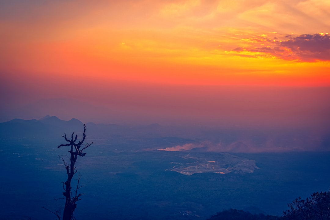
🌋 Earth’s Dynamic Processes
Welcome back, fellow explorers of our amazing planet! While we often marvel at Earth’s visible wonders – majestic mountains, sprawling oceans, and vibrant ecosystems – it’s the constant, often imperceptible, dance of its unseen forces that truly shapes our world. These aren’t static features; they are products of continuous, powerful processes unfolding beneath our feet and above our heads. Understanding these dynamic processes is key to grasping how Earth truly works, from the deepest mantle to the highest atmosphere.
🌍 The Restless Crust: Plate Tectonics
Imagine the Earth’s rigid outer shell, the lithosphere, not as a single, unbroken sphere, but as a colossal, cracked puzzle. These puzzle pieces are called tectonic plates, and they are in constant, albeit incredibly slow, motion. Driven by convection currents in the Earth’s mantle, these plates grind, collide, and pull apart, defining the very geography of our planet.
- ✅ Convergent Boundaries: Where plates collide. This can result in spectacular mountain ranges (like the Himalayas, where the Indian and Eurasian plates meet), or the subduction of one plate beneath another, forming deep oceanic trenches and volcanic arcs (think of the “Ring of Fire” around the Pacific Plate).
- ➡️ Divergent Boundaries: Where plates pull apart, creating new crustal material. The Mid-Atlantic Ridge is a prime example, a vast underwater mountain range where new ocean floor is continuously formed.
- 💡 Transform Boundaries: Where plates slide past each other horizontally. The most famous example in North America is the San Andreas Fault in California, where the Pacific Plate grinds past the North American Plate. This friction is the primary cause of California’s frequent seismic activity.
Non-Obvious Insight: While plate movements are typically measured in centimeters per year (about as fast as your fingernails grow!), their cumulative power over geological timescales is immense, capable of lifting entire continents or carving vast ocean basins.
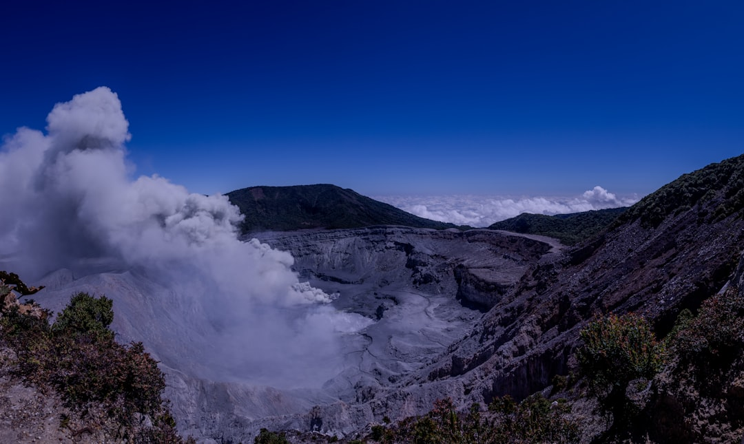
🔥 Beneath the Surface: Volcanism and Geothermal Activity
Volcanoes are not merely isolated mountains; they are direct windows into Earth’s fiery interior, often found along plate boundaries or above “hot spots” where plumes of magma rise from the mantle. Volcanism is a crucial part of the planet’s heat release mechanism.
- ✅ Magma Chambers: Vast reservoirs of molten rock beneath the surface. When pressure builds, this magma, now called lava, erupts, forming volcanoes.
- ➡️ Geothermal Energy: A less dramatic but equally powerful manifestation of this inner heat is geothermal activity. Places like Iceland or New Zealand harness this heat to generate electricity, demonstrating a practical application of these unseen forces. Even in the United States, locations such as The Geysers in California are major geothermal power producers.
- 💡 Pro Tip: Beyond the immediate hazards, volcanic eruptions play a vital role in Earth’s long-term atmospheric composition and soil fertility, enriching landscapes over millennia.
💨 The Breath of the Planet: Atmospheric & Oceanic Dynamics
Beyond the solid Earth, dynamic processes are constantly at play in our atmosphere and oceans, driving weather, climate, and vast energy transfers. These fluid dynamics are powered primarily by solar radiation and Earth’s rotation.
- ✅ Global Air Circulation: Driven by uneven heating, large-scale atmospheric cells (like the Hadley, Ferrel, and Polar cells) distribute heat from the equator towards the poles, creating prevailing wind patterns, including the crucial Jet Streams that steer weather systems.
- ➡️ Oceanic Conveyor Belt: Vast ocean currents, both surface (e.g., the powerful Gulf Stream) and deep-water, transport heat, nutrients, and gases around the globe, profoundly influencing regional climates. This immense system acts like Earth’s global thermostat.
- 💡 Crucial Connection: These natural dynamics are increasingly influenced by human activities. The California’s Fourth Climate Change Assessment highlights how altered atmospheric and oceanic patterns, exacerbated by greenhouse gas emissions, are leading to more extreme weather events, sea-level rise, and shifts in precipitation across the state, underscoring the critical interplay between human action and Earth’s dynamic systems.
Concrete Example: Monitoring these vast systems relies on sophisticated satellite platforms like those from ESA’s Copernicus program or NASA’s Earth Observing System (EOS), which provide invaluable data on ocean temperatures, sea-level height, atmospheric composition, and ice sheet changes.
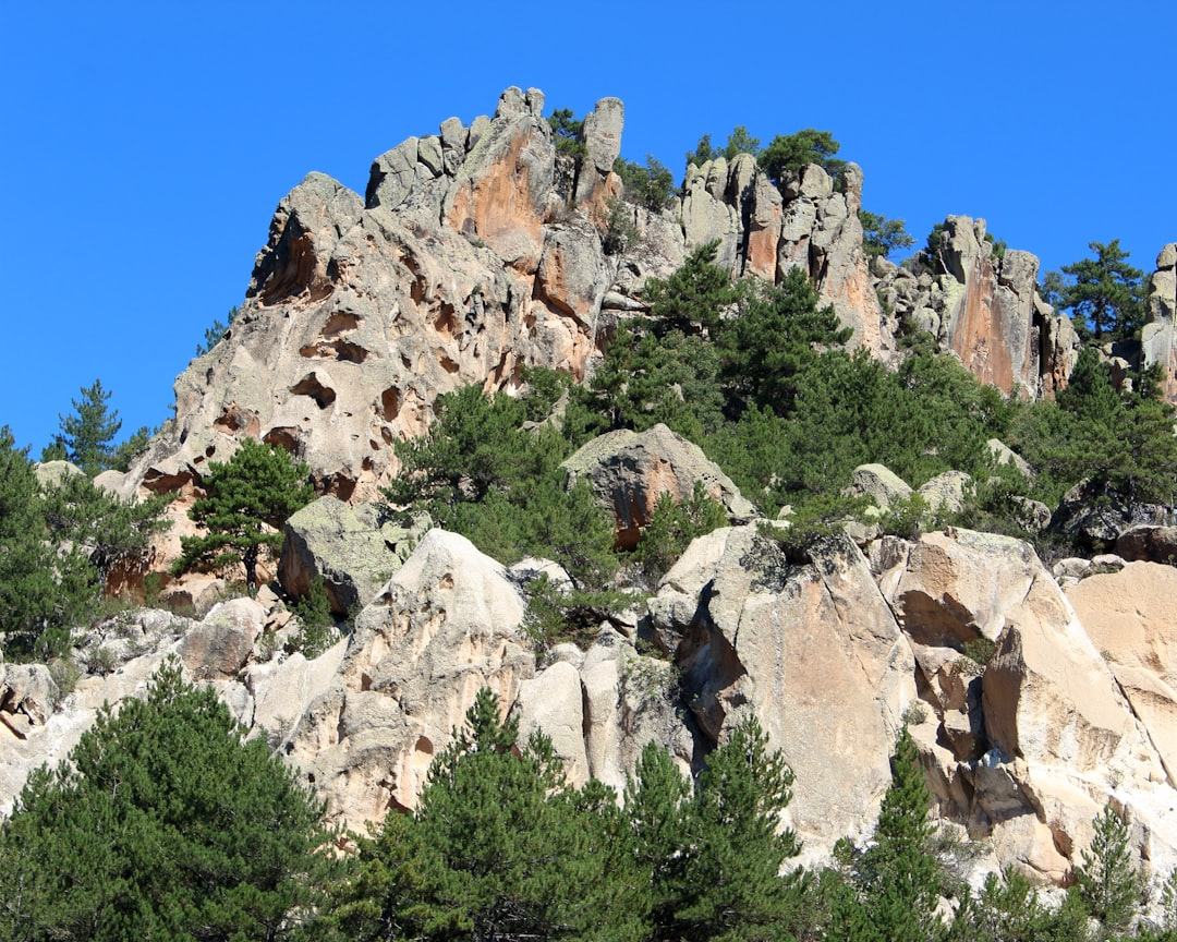
💧 The Sculptors: Erosion and Sedimentation
Even the seemingly static landmasses are continuously being sculpted by the dynamic forces of erosion and sedimentation. Water, wind, and ice are the planet’s tireless sculptors.
- ✅ Water: From the slow dissolution of limestone to the powerful carving of rivers (think of the formation of the Grand Canyon over millions of years), water is the primary agent of erosion. It also transports vast amounts of sediment, depositing it in deltas (like the Mississippi River Delta) or deep ocean basins.
- ➡️ Wind: In arid regions, wind can be a significant erosional force, shaping dunes and eroding exposed rock, and transporting fine particles across continents.
- 💡 Ice: During glacial periods, immense ice sheets act like gigantic bulldozers, carving valleys, transporting boulders, and depositing vast quantities of till and moraines as they melt.
Non-Obvious Insight: These processes are not just destructive; they are fundamental to the global rock cycle, breaking down existing rocks to create new sedimentary layers that can eventually be transformed back into new rock formations. It’s an endless cycle of creation and recreation.
- The Wilson Cycle: Understanding Continents’ Constant Motion
- Shear Zone Geology: Earth’s Deformational Hotspots
- Earth Geology Explained: Dynamic Forces Shaping Our Planet
- Plate Tectonics Explained: A Comprehensive Guide
- Plate Tectonics Theory: From Continental Drift to Modern Understanding
- Earth Science Essentials: Understanding Plate Tectonics
- Earth’s Rotation: Unseen Forces Shaping Our Planet
- Earth’s Geo Plates: Understanding Plate Tectonics
- Atlantic Ocean Plates: Dynamics of the Mid-Atlantic Ridge
- Earth’s Tectonic Plates: Major and Minor Plates Explained
⛏️ Applied & Environmental Geology

While theoretical geology delves into the Earth’s fundamental processes, Applied & Environmental Geology takes that profound understanding and puts it to work. This isn’t just about rocks and minerals in a lab; it’s about solving real-world problems, from securing our energy supply to safeguarding communities from natural disasters and cleaning up our planet. It’s the essential bridge between Earth science and practical engineering, urban planning, and environmental stewardship.
⚙️ Beyond the Textbook: What It Is
At its core, applied geology is about predicting and managing the Earth’s behavior in the context of human activity. Environmental geology specifically focuses on the interactions between geological materials, processes, and the environment, particularly where human health and infrastructure are concerned. Think of it as Earth’s problem-solvers, working on the front lines of sustainability and safety.
- ✅ Resource Security: Locating and sustainably extracting vital resources like water, minerals, and energy.
- ✅ Hazard Mitigation: Understanding, predicting, and mitigating the risks posed by earthquakes, landslides, volcanoes, and tsunamis.
- ✅ Environmental Protection: Assessing environmental impacts, managing waste, and remediating contaminated sites.
- ✅ Infrastructure Resilience: Ensuring the stability and safety of buildings, dams, roads, and tunnels.
⛰️ Resource Exploration & Management
One of the oldest applications of geology is the search for natural resources. This field is far more sophisticated than simply digging where you think there might be gold. Modern resource geologists use cutting-edge techniques to identify and assess deposits.
- ➡️ Energy Resources: Geologists are crucial in the oil and gas industry, using seismic imaging and drilling data to find new hydrocarbon reservoirs. Companies like ExxonMobil and Chevron rely heavily on geological models to guide their exploration efforts. For renewable energy, they assess geothermal potential or the geological stability for large-scale wind farm foundations.
- ➡️ Mineral Resources: From the rare earth elements essential for our electronics to the copper in our wiring, mineral geologists guide the exploration. Techniques involve remote sensing (using satellite data, often processed with platforms like ESRI ArcGIS), geophysical surveys, and detailed core logging to determine the economic viability and extent of an ore body.
- ➡️ Water Resources: Hydrogeologists locate and manage groundwater reserves, critical for agriculture and drinking water, especially in arid regions. They model aquifer systems and monitor for depletion or contamination.
- 💡 Non-Obvious Insight: The shift isn’t just about finding resources, but about their sustainable extraction and the responsible closure of sites, often mandated by regulatory bodies to minimize long-term environmental liabilities.
⚠️ Geohazard Mitigation & Risk Assessment
The Earth’s dynamic nature means constant geological hazards. Applied geologists are essential in reducing their impact on human lives and infrastructure.
- ➡️ Earthquakes & Volcanoes: Seismologists and volcanologists monitor active faults and volcanic systems, providing critical data for early warning systems. Engineers then use this geological data to design earthquake-resistant buildings and infrastructure.
- ➡️ Landslides & Sinkholes: Geologists map unstable slopes and areas prone to sinkhole collapse, often using ground-penetrating radar (GPR) and LiDAR data. This helps urban planners avoid high-risk zones and design stabilization measures. The geological assessment of ground stability is fundamental before any major construction, preventing costly and dangerous failures down the line.
- 💡 Common Mistake: Underestimating the long-term, subtle changes in ground stability. For example, slight variations in groundwater levels can significantly alter the load-bearing capacity of soils, leading to unexpected subsidence or slope failures years after initial construction. Thorough geotechnical surveys are paramount.
🌊 Environmental Protection & Remediation
This is where environmental geology truly shines, addressing the legacy and ongoing impacts of human activity on the geological environment.
- ➡️ Contaminated Land & Groundwater: Geologists assess the movement of pollutants through soil and groundwater, designing remediation strategies. This often involves detailed hydrogeological modeling and sophisticated clean-up technologies. Firms like AECOM and Jacobs Engineering Group have large environmental geology divisions dedicated to such projects, often for industrial sites or former landfills.
- ➡️ Waste Management: From municipal solid waste to hazardous industrial waste, environmental geologists evaluate sites for landfill development, ensuring that geological barriers prevent leachate migration into groundwater. They also oversee the safe geological disposal of nuclear waste, a highly complex and long-term challenge.
- ➡️ Climate Change Impacts: As global temperatures rise, the interactions between geological processes and the environment become even more critical. Geologists study how melting glaciers affect permafrost stability, how sea-level rise exacerbates coastal erosion, and how altered precipitation patterns increase landslide risks. For instance, the New York State Department of Environmental Conservation (NYSDEC) highlights how climate change impacts in New York include increased heavy downpours, leading to more runoff, erosion, and potential for flash floods, all of which directly involve geological and hydrological processes that environmental geologists must understand and help manage.
- 💡 Pro Tip: Effective environmental remediation isn’t just about cleaning up; it’s about understanding the unique geological and hydrological fingerprint of a site to prevent future contamination and ensure the solution is sustainable.
🏙️ Infrastructure & Urban Planning
Every building, bridge, tunnel, and road relies on a stable foundation. Engineering geologists are the unsung heroes of urban development.
- ➡️ Site Characterization: Before any major construction, geologists conduct detailed site investigations to understand the subsurface conditions, identifying potential challenges like weak soils, expansive clays, or karst topography (areas prone to sinkholes). This involves drilling boreholes, conducting geophysical surveys, and laboratory testing of soil and rock samples.
- ➡️ Tunneling & Dam Construction: For complex projects like underground transit systems (e.g., the vast networks in London or New York) or hydroelectric dams, understanding the rock mechanics and groundwater flow is paramount to ensuring stability and preventing catastrophic failures during and after construction.
- 💡 Non-Obvious Insight: The best geological analysis for infrastructure projects isn’t just about the present-day conditions, but also predicting how the ground will react over decades to changes in load, water saturation, and even seismic activity. It’s truly about long-term forecasting.
🛠️ Key Skills & Tools for the Applied Geologist
The tools of the trade for an applied and environmental geologist are diverse and constantly evolving:
- ✅ Geographic Information Systems (GIS): Software like ESRI ArcGIS Pro or open-source alternatives like QGIS are indispensable for mapping, analyzing, and visualizing geological data, hazards, and environmental impacts.
- ✅ Remote Sensing: Satellite imagery, LiDAR (Light Detection and Ranging), and drone-based surveys provide vast amounts of data for geological mapping, monitoring land deformation, and assessing vegetation health as an indicator of subsurface conditions.
- ✅ Geophysical Methods: Techniques such as seismic reflection, ground-penetrating radar, and electrical resistivity imaging are used to “see” into the subsurface without extensive drilling, helping to identify bedrock depth, fault lines, or contaminant plumes.
- ✅ Numerical Modeling: Sophisticated software is used to simulate groundwater flow, contaminant transport, slope stability, and seismic wave propagation, allowing geologists to predict outcomes and design effective interventions.
- 💡 Interdisciplinary Collaboration: Perhaps the most critical “skill” is the ability to collaborate effectively with engineers, hydrologists, chemists, planners, and policymakers. Applied geology is rarely a solo act; it thrives on teamwork.
- Biogeology: Where Life Meets Earth Sciences
- Applied Geology: Solving Real-World Challenges
- Engineering Geology: Building Safely on Earth
- Medical Geology: Earth’s Impact on Human Health
- Environmental Geology: Protecting Earth’s Natural Systems
- Urban Geology: How Earth Shapes Our Cities
- Human Geology: How We Reshape the Earth’s Surface
- Resource Geology: Unearthing Earth’s Natural Assets
- Oil and Gas Geology: Exploring Earth’s Hydrocarbon Resources
- Basin Geology: Formation and Resource Potential
🪨 Geological Features & Materials

Beneath the vibrant tapestry of life on Earth lies a foundational layer of geological features and materials, constantly shaped by powerful, often unseen forces. From the towering peaks of mountain ranges to the hidden veins of precious minerals, everything we see and use is a product of these deep planetary dynamics. Understanding these elements isn’t just academic; it’s crucial for resource management, infrastructure planning, and navigating natural hazards.
🌍 The Crust’s Dynamic Canvas: Plate Tectonics in Action
The Earth’s outermost layer, the lithosphere, isn’t a solid shell but a jigsaw puzzle of immense pieces called tectonic plates. These plates are in perpetual, slow-motion dance, driven by convection currents deep within the mantle. Their interactions are the primary architects of our planet’s large-scale geological features.
- ✅ Convergent Boundaries: Where plates collide, one often dives beneath the other (subduction), leading to intense geological activity. This forms immense mountain ranges like the Himalayas (where the Indian plate crashes into the Eurasian plate) or volcanic arcs like those around the Pacific Ring of Fire.
- ➡️ Divergent Boundaries: Plates pull apart, allowing molten rock (magma) to rise and create new crust. The Mid-Atlantic Ridge, an underwater mountain range, is a prime example, continuously growing and pushing continents apart. This process, while slow, fundamentally alters ocean basins over geological time.
- 💡 Transform Boundaries: Plates slide past each other horizontally. These zones are notorious for generating powerful earthquakes, such as those along California’s San Andreas Fault. Unlike convergent or divergent boundaries, little crust is created or destroyed here, but the immense friction releases tremendous energy.
A non-obvious insight here is the concept of isostasy, where sections of the Earth’s crust float at an elevation dependent on their thickness and density. This means mountains aren’t just built up, they’re also ‘floating’ on the denser mantle, and their erosion can lead to crustal rebound over millennia. This ongoing adjustment subtly influences everything from sea levels to gravitational anomalies.
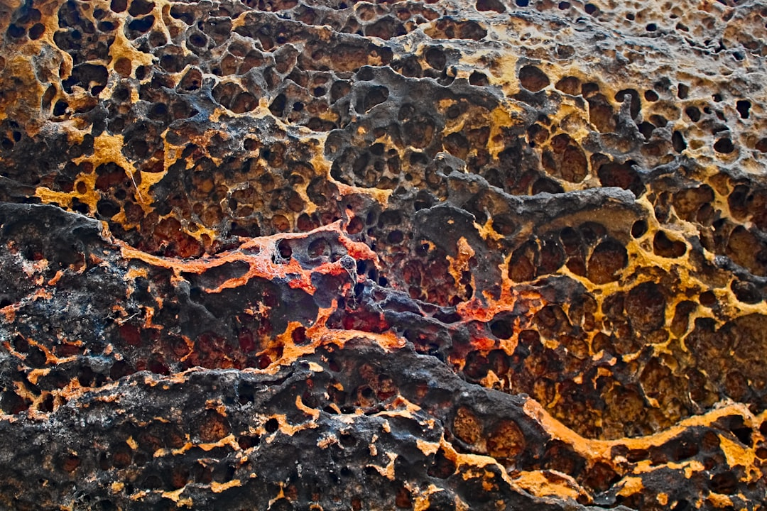
🪨 Rocks: The Planet’s Enduring Architects
Rocks are the fundamental building blocks of our planet’s crust, each type telling a story of its formation and the forces that shaped it. They are broadly categorized into three types:
- 🔥 Igneous Rocks: Formed from the cooling and solidification of molten magma or lava. Think of granite, a common intrusive igneous rock used in countertops, or basalt, which makes up most of the oceanic crust and is seen in features like the Giant’s Causeway. Understanding their mineral composition can indicate potential for valuable ore deposits.
- 💧 Sedimentary Rocks: Formed from the accumulation and compaction of sediments (fragments of other rocks, minerals, or organic matter). Sandstone and limestone are classic examples, often containing fossils that provide invaluable insights into past environments and life forms. These rocks are critical for understanding ancient climates and are often excellent reservoirs for oil, gas, and groundwater.
- ✨ Metamorphic Rocks: Created when existing rocks are transformed by intense heat, pressure, or chemical alteration, without melting. Marble (from limestone) and slate (from shale) are examples. The unique banding patterns in metamorphic rocks like gneiss reveal the immense pressures they’ve endured deep within the Earth.
Common Mistake: Many assume rocks are static. In reality, the rock cycle is a continuous, dynamic process where rocks are constantly being created, destroyed, and transformed by plate tectonics, weathering, and erosion. Recognizing the local rock types provides critical information for construction stability, water sourcing, and even agricultural potential, as different rocks weather into different soil types.
💎 Minerals: The Invisible Components, Unseen Value
While rocks are aggregates of minerals, minerals themselves are naturally occurring solid substances with a defined chemical composition and crystal structure. They are the true ‘hidden wealth’ of our planet, underpinning nearly every aspect of modern society.
- 💡 Abundant Fundamentals: Minerals like quartz (a component of sand and granite) and feldspar are incredibly common. Quartz, specifically, is a key raw material for silicon chips used by tech giants like Intel and Nvidia, making it an unseen but critical component of the digital world.
- 💰 Strategic Resources: Other minerals possess immense economic and strategic value. Lithium, cobalt, and nickel are essential for the batteries powering electric vehicles from companies like Tesla and smartphones worldwide. The global distribution and extraction of these minerals are significant geopolitical factors.
- ⛏️ From Ore to Utility: Minerals are extracted from the Earth as ores and then processed into usable materials. For instance, bauxite ore is processed to yield aluminum, a lightweight metal vital for aerospace and beverage industries. Understanding the geological conditions under which these minerals form is key to successful exploration, often guided by geological surveys from organizations like the USGS (U.S. Geological Survey) or the British Geological Survey (BGS).
The crystalline structure of a mineral dictates its physical properties, from hardness to electrical conductivity, directly influencing its utility. This microscopic arrangement is a testament to the unseen forces of pressure, heat, and chemical reactions over eons.
🌊 Surface Sculptors: Weathering, Erosion & Deposition
Beyond the deep-seated forces of plate tectonics, the Earth’s surface is continually reshaped by more immediate, atmospheric, and hydrological forces:
- 🌬️ Weathering: The process that breaks down rocks and minerals at or near the Earth’s surface. This can be mechanical weathering (e.g., frost wedging cracking rocks apart, like in colder climates where rock faces might splinter) or chemical weathering (e.g., acid rain dissolving limestone to form caves, such as the famous Carlsbad Caverns).
- 🏞️ Erosion: The movement of weathered material by agents like water, wind, ice (glaciers), and gravity. The Grand Canyon is a spectacular example of erosion by the Colorado River, carving through layers of sedimentary rock over millions of years. Glacial erosion carved the iconic U-shaped valleys of places like Yosemite National Park.
- ➡️ Deposition: The process where eroded material settles down in a new location, often forming new landforms or sedimentary layers. River deltas, like the vast Mississippi River Delta, are prime examples of deposition, constantly adding new land as sediment is carried downstream.
These forces, while often slow and imperceptible on a daily basis, have created and continue to reshape all the landscapes we see. Non-Obvious Insight: The interaction between climate and these processes is profound. Changes in temperature, rainfall patterns, or glacial activity directly alter the rate and type of weathering and erosion, leading to dynamic landscape evolution. Ignoring these long-term trends can lead to significant infrastructure challenges, from dam silting to coastal erosion impacting properties.
🗺️ Practical Applications: Navigating Geological Realities
A deep understanding of geological features and materials isn’t just for geologists; it’s a strategic advantage for virtually any industry interacting with the land:
- 🏗️ Infrastructure Development: Before building a skyscraper, bridge, or tunnel, engineers rigorously analyze the underlying geology to ensure stability, assess seismic risks, and identify suitable foundation materials. Companies like AECOM and Jacobs Engineering Group rely heavily on geological assessments for their large-scale projects.
- ⚙️ Resource Exploration & Mining: Identifying economically viable deposits of minerals, metals, fossil fuels, and groundwater requires extensive geological expertise. Global mining giants like BHP Billiton and Rio Tinto invest billions in geological surveys and exploration to locate and extract these crucial materials.
- ⚠️ Hazard Mitigation: Understanding fault lines, unstable slopes, volcanic zones, and floodplains is paramount for developing effective strategies to mitigate natural disasters. Agencies like the Federal Emergency Management Agency (FEMA) and local emergency services utilize geological data to plan evacuation routes and construct resilient infrastructure.
- 🌳 Environmental Management: Geological knowledge is vital for managing groundwater resources, assessing soil contamination, and planning waste disposal sites. The permeability of rock layers, for instance, dictates how quickly pollutants can spread or how effectively water can be stored in aquifers.
💡 Strategic Advantage: Regularly consulting geological maps and reports from reputable sources like the USGS or local geological surveys is not just a best practice; it’s a non-negotiable step for any significant land-use planning or investment. These resources provide invaluable data on rock types, fault lines, groundwater levels, and potential hazards, offering a critical unseen layer of due diligence.
- Mesa Geology: Unraveling Flat-Topped Mountain Secrets
- Bedrock Geology: Earth’s Unseen Foundation
- Marble Geology: From Limestone to Luxurious Stone
- Sandstone Geology: Decoding the Story in Sedimentary Rocks
- Grain Size in Geology: Understanding Sedimentary Stories
- Coastal Geology: Shorelines, Sea Level Rise, and Dynamic Coasts
- Soft Rock Geology: Exploring Earth’s Malleable Foundations
- Surficial Geology: Unearthing Earth’s Top Layer Secrets
- Chert Geology: Hardness, Origin, and Cryptocrystalline Nature
- Flute Cast Geology: Decoding Sedimentary Structures
🗺️ Regional & Global Geological Studies

To truly grasp Earth’s hidden dynamics, we must elevate our perspective beyond the local outcrop or single fault line. Regional and global geological studies are the bedrock of understanding our planet’s unseen forces, enabling us to connect disparate observations into a coherent, dynamic system. This holistic approach is akin to assembling a colossal 3D puzzle, where each piece—from seismic waves to satellite imagery—reveals a crucial part of the larger picture.
These expansive studies aren’t just academic exercises; they are fundamental for everything from predicting volcanic eruptions and earthquakes to locating vital mineral resources and assessing climate change impacts. They allow us to see Earth not as a static ball of rock, but as a living, breathing entity driven by immense, often invisible, forces.
🛰️ The Art of Large-Scale Data Acquisition
Understanding Earth on a regional or global scale demands an unprecedented volume and variety of data. Gone are the days of solely relying on individual field measurements; today, we leverage sophisticated technologies that can peer into the Earth from space or record its subtle tremors from thousands of kilometers away. The key is multi-source data integration.
- 📡 Satellite Remote Sensing: Platforms like the European Space Agency’s Sentinel missions or NASA’s GRACE (Gravity Recovery and Climate Experiment) provide invaluable insights. Sentinel uses radar interferometry (InSAR) to detect ground deformation with millimeter precision, revealing subtle shifts before major seismic events or volcanic unrest. GRACE measures changes in Earth’s gravity field, indicating shifts in mass like groundwater depletion or glacial melt, which can influence crustal loading.
- 🌎 Global Seismic Networks: The IRIS Consortium (Incorporated Research Institutions for Seismology) operates and coordinates a vast network of seismic stations worldwide. These stations continuously record ground motion, allowing seismologists to map Earth’s interior structure by analyzing how seismic waves propagate, reflect, and refract through different layers. This is how we confirm the existence of the liquid outer core or image mantle plumes.
- 🧪 Geophysical Surveys (Airborne & Marine): Specialized aircraft equipped with magnetometers or gravimeters map subsurface structures over vast regions, identifying anomalies that could indicate ore deposits or geothermal reservoirs. Similarly, research vessels deploy seismic streamers and bathymetric sonar to map the ocean floor and sub-seafloor geology, crucial for understanding plate boundaries and marine hazards.
- 🕳️ Deep Drilling & Borehole Observatories: While costly, projects like the International Ocean Discovery Program (IODP) or continental deep drilling initiatives provide direct samples and in-situ measurements from deep within the Earth’s crust. Borehole observatories, often deployed in seismically active zones, can monitor strain, fluid pressure, and temperature changes at depth, offering a window into the conditions leading to earthquakes.
Non-Obvious Insight: A common mistake is to treat these data streams in isolation. The real power comes from their synergistic combination. For instance, combining InSAR data with seismic velocity models can provide a much clearer picture of fault locking and stress accumulation than either dataset could alone.
💻 Integrated Modeling & Predictive Power
Collecting vast amounts of data is only half the battle. The next, and arguably more complex, step is to synthesize this information into meaningful models that enhance our understanding and predictive capabilities. This is where advanced computational tools become indispensable.
- 📊 Geographic Information Systems (GIS): Software like Esri’s ArcGIS Pro or open-source alternatives like QGIS are fundamental for layering, visualizing, and analyzing diverse geological datasets. They allow researchers to overlay seismic epicenters with fault maps, integrate satellite deformation data with topographical features, and map mineral occurrences across entire continents.
- 🧠 Numerical Modeling & Simulation: Geoscientists use sophisticated software to simulate complex geological processes. For example, finite element models can simulate stress accumulation on faults, fluid dynamics models predict magma movement in volcanoes, and mantle convection models help us understand the driving forces behind plate tectonics. Companies specializing in these tools, though less ‘brand-name’ to the public, include those developing software for oil and gas exploration, such as Schlumberger’s Petrel platform or Paradigm’s suite of software.
- 🤖 Artificial Intelligence & Machine Learning: The sheer volume of geological data makes it a prime candidate for AI applications. ML algorithms are increasingly used to detect subtle patterns in seismic waveforms that might indicate impending earthquakes, identify anomalous heat signatures from satellite imagery that could signal volcanic activity, or even predict the location of new mineral deposits based on existing geological and geophysical data. This is a rapidly evolving field, with academic institutions often leading the charge in developing custom algorithms.
Pro Tip: The quality of your model is directly proportional to the quality and diversity of your input data. A single, high-resolution dataset might be powerful, but combining multiple, complementary datasets, even if individually lower resolution, often leads to more robust and accurate models.
🌍 Global Insights & Unseen Connections
The culmination of regional and global geological studies is a deeper, more integrated understanding of Earth’s unseen forces. These studies reveal profound connections that would be impossible to discern from a localized perspective.
- 🌋 Understanding Plate Tectonics: Global studies of seismic activity, volcanism, and crustal deformation directly support and refine our understanding of plate boundaries, subduction zones, and rift valleys. They highlight how forces originating deep within the mantle drive surface phenomena.
- 🔥 Hazard Assessment & Mitigation: By mapping regional fault networks and historical seismicity, or monitoring volcanic deformation across an entire arc, we can create more accurate hazard maps and develop early warning systems. This directly impacts public safety and infrastructure planning, for example, identifying areas prone to liquefaction during earthquakes or mapping potential tsunami inundation zones.
- 💰 Resource Exploration: Global geophysical surveys (e.g., gravity, magnetic) and regional geological mapping help identify areas with high potential for mineral deposits (e.g., copper, gold, rare earth elements) or hydrocarbon reservoirs by revealing underlying geological structures associated with their formation. Companies like BHP or Rio Tinto rely heavily on these large-scale studies in their exploration divisions.
- 💧 Climate Change & Earth Systems Interaction: Studies of global ice sheet dynamics (monitored by satellites like ICESat-2), sea-level change, and crustal rebound from deglaciation all contribute to our understanding of how Earth’s solid surface interacts with its hydrosphere and atmosphere, and how these interactions are accelerating due to climate change.
Conclusion: Regional and global geological studies are not just about collecting more data; they are about connecting the dots, revealing the intricate dance of forces that shape our planet. They empower us to move from isolated observations to a coherent, predictive understanding of Earth’s hidden dynamics, making the unseen, at least partially, visible.
- Himalayan Geology: Formation of the World’s Highest Mountains
- China’s Geology: Ancient Tectonics and Abundant Resources
- Quaternary Geology: Exploring Earth’s Recent Ice Ages
- Piedmont Geology: Exploring Ancient Mountain Foothills
- Kokinou Geology: Unearthing Earth’s Hidden Structures
- Regional Geology: Mapping Earth’s Structures
- Lineament Geology: Identifying Structural Features from Above
- South American Plate: Dynamics and Geological Impact
- Australian Plate: Movement, Collisions, and Geology
- BGS Borehole Records: Unearthing Earth’s Secrets
🎓 Geology Learning & Resources
📚 Formal Education Pathways
For those truly committed to unraveling Earth’s unseen forces, a formal education in geology or a related Earth science discipline offers the most comprehensive and structured foundation. This path provides not just factual knowledge but also critical thinking skills, research methodologies, and hands-on experience vital for a deep understanding.
- ✅ Undergraduate Degrees (B.Sc.): A Bachelor of Science in Geology, Earth Science, Geophysics, or Environmental Geology is the traditional starting point. Programs typically include core courses in mineralogy, petrology, structural geology, stratigraphy, paleontology, and geophysics.
- ➡️ Actionable Tip: Look for programs with strong field components, including mandatory field camps. Universities like the University of Wyoming, Colorado School of Mines, or University of Montana are renowned for their field-intensive curricula, often leveraging nearby geological features.
- ✅ Graduate Studies (M.Sc., Ph.D.): For specialized research, academic careers, or advanced industry roles, a Master’s or Doctoral degree is often essential. This allows you to delve deep into specific areas like volcanology, seismology, hydrogeology, or planetary geology.
- 💡 Non-Obvious Insight: When selecting a graduate program, don’t just look at the university’s ranking. Focus on the specific research interests of the faculty members you’d like to work with. A strong mentor is far more valuable than a top-ranked department if their research doesn’t align with your passion.
💻 Online & Self-Paced Learning
Formal degrees are invaluable, but the digital age has democratized learning, allowing anyone to explore geological concepts at their own pace. These resources are excellent for supplementing formal education, exploring new interests, or refreshing forgotten knowledge.
- ✅ MOOCs (Massive Open Online Courses): Platforms like Coursera, edX, and FutureLearn host geology and Earth science courses from world-leading universities. Many offer introductory to advanced topics, often with flexible schedules.
- ➡️ Concrete Examples: Search for “Geology” or “Earth Science” courses offered by institutions like the University of Leeds on FutureLearn, or Caltech and University of Alberta on Coursera.
- ✅ Specialized Online Resources: Organizations and government agencies often provide incredible educational materials.
- 💡 Pro Tip: The U.S. Geological Survey (USGS) website (www.usgs.gov) is a treasure trove of data, maps, publications, and educational content, freely available. Similarly, the British Geological Survey (BGS) and other national geological surveys offer vast resources. Don’t underestimate the power of their educational sections!
- ➡️ Visual Learning: YouTube channels such as “Geology Hub” or university-affiliated channels like “AGU (American Geophysical Union) TV” provide engaging lectures, documentaries, and field trip summaries that bring concepts to life.
⛏️ Hands-On Experience: The Field is Your Classroom
Geology is fundamentally an observational science. No amount of textbook reading can replace the insights gained from direct interaction with rocks, landscapes, and geological processes. This is where the unseen forces truly reveal themselves.
- ✅ Field Camps & Excursions: If you’re pursuing a degree, mandatory field camps are crucial. For self-learners, look for short courses or guided geological tours offered by universities or private groups.
- 💡 Non-Obvious Insight: Fieldwork teaches you to “see” the geology, not just look at it. It develops crucial skills in observation, measurement, hypothesis testing, and spatial reasoning that are impossible to replicate in a classroom. Embrace the dirt, the weather, and the long hikes—it’s where real understanding happens.
- ✅ Volunteering & Internships: Gaining practical experience with geological surveys, environmental consulting firms, or research labs can provide invaluable exposure to real-world applications and methodologies.
- ➡️ Actionable Tip: Reach out to local geological societies or university departments. They often know of opportunities for volunteers or research assistants. Even assisting with sample preparation or data entry can provide a foot in the door.
🤝 Professional Associations & Networking
Connecting with fellow geoscientists is vital for continuous learning, career development, and understanding the cutting edge of the field. These networks are rich sources of knowledge and mentorship.
- ✅ Membership in Professional Societies: Join organizations that align with your interests.
- ➡️ Concrete Examples: The Geological Society of America (GSA), the American Geophysical Union (AGU), and regional societies (e.g., California Geological Survey, Houston Geological Society) offer conferences, publications, and networking events. Many have student or early-career professional rates.
- 💡 Pro Tip: Attend their annual meetings or local chapter events. The informal conversations at coffee breaks or poster sessions can be as insightful as the formal presentations. Don’t be shy; geologists are generally eager to share their passion.
- ✅ Online Professional Networks: LinkedIn is an excellent platform for connecting with geoscientists, following companies, and finding relevant industry news and job postings.
- ➡️ Actionable Tip: Engage with content, participate in discussions, and don’t hesitate to send polite connection requests to professionals whose work interests you.
⚙️ Essential Tools & Software
Modern geology relies heavily on technology for data collection, analysis, and visualization. Becoming proficient with key software packages will significantly enhance your learning and future career prospects.
- ✅ Geographic Information Systems (GIS): GIS is indispensable for mapping, analyzing spatial data, and understanding geological relationships.
- ➡️ Concrete Examples: Esri ArcGIS Pro is the industry standard, though QGIS offers a powerful open-source alternative. Many universities offer discounted licenses or free access for students.
- 💡 Non-Obvious Insight: Don’t just learn how to use GIS software; learn how to think spatially. Understand projections, coordinate systems, and how to query and manipulate geological datasets to extract meaningful insights. This analytical thinking is more valuable than button-pushing.
- ✅ Remote Sensing Software: Tools for processing satellite imagery and aerial photographs are crucial for large-scale geological mapping and monitoring.
- ➡️ Examples: ENVI, ERDAS Imagine, or even GIS software with remote sensing extensions.
- ✅ Data Analysis & Programming: As geology becomes more data-intensive, basic proficiency in programming languages can be a huge asset.
- ➡️ Actionable Tip: Learning Python or R for data manipulation, statistical analysis, and visualization is becoming increasingly important in modern geoscience. Online tutorials and platforms like DataCamp or Codecademy can get you started.
- ✅ Google Earth Pro: While not a professional mapping tool, it’s an incredible resource for exploring geological features globally, visualizing topography, and planning virtual field trips. It’s free and intuitive.
- Web Geology: Exploring Earth Science Online
- Minecraft Geology: Learning Earth Science Virtually
- Geology Today: Latest Discoveries Shaping Our Understanding
- IIT Geology Programs: A Guide to India’s Best Earth Science Programs
- Top Geology Websites: Your Earth Science Knowledge Gateway
- UPSC Geology Optional: A Guide for Civil Services Aspirants
- Geology.com: Your Ultimate Resource for Rocks and Minerals
- James Hutton: Father of Modern Geology
- Geography vs. Geology: Interconnected Earth Sciences
- AP Earth Science: A Comprehensive Study Guide
🚀 Space Exploration & Planetary Geology

Understanding Earth by Looking Outward 🔭
While our guide focuses on Earth’s unseen forces, it’s virtually impossible to fully grasp our planet’s hidden dynamics without looking beyond it. Planetary geology, a fascinating sub-discipline, uses the entire Solar System as a laboratory. By studying the geological evolution and processes of other celestial bodies, we gain crucial context and often, direct insights into Earth’s past, present, and even its future.
- ✅ Comparative Planetology: This is the bedrock. For example, observing Mars’s heavily cratered ancient terrains alongside its younger, volcanic plains helps us understand the early bombardment phase of the inner Solar System, a period that significantly shaped early Earth. Seeing Mars’s thin atmosphere and lack of a global magnetic field offers a stark contrast to Earth, highlighting the critical role of our magnetosphere in retaining water and atmosphere.
- ➡️ Unraveling Planetary Fates: Consider Venus with its runaway greenhouse effect, a thick, hot atmosphere, and recent volcanic activity. It serves as a cautionary tale, illustrating how planetary climates can diverge dramatically, even for worlds initially similar in size to Earth. Studying its internal heat mechanisms, perhaps through radar mapping (as with NASA’s Magellan mission), offers clues to processes that might have once dominated Earth’s early, more tectonically active phases.
- 💡 The Grand Experiment: Think of each planet and moon as a unique natural experiment. Why does Jupiter’s moon Io have such intense volcanism? Tidal forces from Jupiter! This helps us understand the immense power of gravitational interactions, which also play a role in Earth’s ocean tides and even some tectonic processes. Conversely, the absence of plate tectonics on most other rocky bodies helps us appreciate how unique and fundamental this process is to Earth’s geological activity, its carbon cycle, and ultimately, its habitability.
Tools of the Trade: Sensing the Unseen Across the Cosmos 🛰️
How do we “see” the unseen forces on planets tens, hundreds, or even billions of miles away? Through an incredible array of sophisticated instruments aboard orbiters, landers, and rovers. These technologies allow us to infer internal structure, atmospheric dynamics, and subsurface conditions.
- ✅ Orbital Remote Sensing:
- Spectrometers: Instruments like those on NASA’s Mars Reconnaissance Orbiter (MRO) or ESA’s Mars Express analyze light reflected from surfaces to identify mineral composition, indicating the presence of water in the past or current volcanic activity.
- Radar & Laser Altimeters: Missions such as the Lunar Reconnaissance Orbiter (LRO) use lasers to map topography with incredible precision, revealing tectonic features, impact structures, and even subsurface ice deposits. Radar (e.g., Cassini’s radar on Titan) can penetrate thick atmospheres or even shallow subsurface layers to map hidden terrains or identify liquid bodies.
- Magnetometers & Gravimeters: These instruments detect subtle variations in a planet’s magnetic or gravitational fields, providing indirect evidence of its internal structure, core dynamics, and mass distribution. For example, the discovery of localized crustal magnetism on Mars provided key evidence for an ancient Martian dynamo, similar to Earth’s.
- ➡️ In-Situ Exploration & “Ground Truth”: While orbital data is vital, nothing beats direct contact.
- Seismometers: NASA’s InSight lander on Mars, for example, listened to “marsquakes” to map the planet’s interior, providing our first direct measurements of the Martian crust, mantle, and core, fundamentally changing our understanding of rocky planet formation.
- Drills & Analytical Tools: Rovers like NASA’s Curiosity and Perseverance on Mars carry sophisticated labs (e.g., ChemCam, PIXL, SHERLOC) that can analyze rock and soil samples on the spot, determining their elemental and mineralogical composition, identifying organic molecules, and even looking for signs of past life. This ‘ground truthing’ is crucial for calibrating and validating the data from orbital missions.
- 💡 A Non-Obvious Insight: The data from these planetary missions doesn’t just inform us about distant worlds. The software, algorithms, and even the materials science developed to build these instruments often find unexpected applications here on Earth, from medical imaging to resource exploration.
The “Ground Truth” from Distant Worlds 🔬
Bringing samples directly back to Earth represents the ultimate “ground truth,” allowing for analyses with laboratory instruments far more sensitive and diverse than anything that can be sent into space. This provides unparalleled detail about extraterrestrial geology and the processes that shape planets.
- ✅ Lunar Sample Legacy: The Apollo missions brought back hundreds of kilograms of lunar rocks and soil. Decades later, these samples are still being analyzed, revealing intricate details about the Moon’s formation, volcanic history, and the early bombardment of the Earth-Moon system. The insights gleaned from these samples are fundamental to understanding the early evolution of all rocky planets.
- ➡️ Future Sample Returns: The current Perseverance rover is not just analyzing samples on Mars; it’s caching them for a future Mars Sample Return mission. This ambitious endeavor aims to bring Martian rocks and soil to Earth, allowing scientists to search for definitive biosignatures, precisely date geological events, and study the long-term interaction of the Martian interior with its surface and atmosphere. This is a game-changer for understanding planetary habitability and evolution.
- 💡 The Micro-Scale Story: Imagine studying individual mineral grains from Mars or the Moon, searching for tiny fluid inclusions, isotopic ratios, or even microscopic fossils. These minuscule details can tell us enormous stories about ancient water cycles, atmospheric composition, and even potential past life – information impossible to gather from remote sensing alone. It’s akin to examining a single grain of sand to understand an entire beach.
Data & Discovery: Navigating the Planetary Data Deluge 💡
Every mission to another planet generates an astonishing volume of data – images, spectra, gravitational measurements, seismic readings, and more. Making sense of this “data deluge” is a critical, often unseen, force in advancing planetary geology. Without proper data management and accessibility, even the most groundbreaking discoveries would remain locked away.
- ✅ The Pillars of Accessibility: Agencies like NASA and ESA maintain vast public archives. A prime example is NASA’s Planetary Data System (PDS), which serves as the long-term archive for data from planetary missions. PDS ensures data is peer-reviewed, well-documented, and usable by anyone, from professional researchers to citizen scientists. Similar resources exist within institutions like the USGS Astrogeology Science Center, which provides extensive mapping tools and data products.
- ➡️ Visualization & Analysis Tools: Scientists use specialized software for analyzing planetary data. While generic GIS platforms like Esri’s ArcGIS are often adapted, dedicated tools such as JPL’s Integrated Software for Imagers and Spectrometers (ISIS), developed by the USGS, are purpose-built for processing and analyzing planetary image data. These tools allow geologists to stitch together thousands of images into global maps, analyze spectral signatures pixel by pixel, and create 3D terrain models.
- 💡 Non-Obvious Insight: The Art of Archiving: The true challenge isn’t just collecting data, but ensuring it remains usable decades later. This means meticulously documenting data formats, instrument calibrations, and processing steps. A common mistake in earlier missions was insufficient metadata, rendering some valuable datasets difficult to interpret today. Modern missions prioritize robust data archiving from their inception, recognizing that the lifespan of the data far exceeds the operational life of the spacecraft. This foresight ensures that future generations of scientists can continue to extract new insights as analytical techniques evolve.
- Mars 2020 Perseverance Rover: Uncovering Red Planet Secrets
- Mars Rovers: A Complete History from Sojourner to Perseverance
- NASA InSight Mars Lander: Probing the Red Planet’s Interior
- Jeff Bezos’s Space Trip: Blue Origin and Commercial Spaceflight
- Lockheed Martin Mars Landers: From Viking to Phoenix
- JPL Mars Missions: Decades of Red Planet Exploration
- Mars Sample Return Mission: Bringing Martian Rocks to Earth
- Regolith in Geology: Soil Formation and Planetary Surfaces
- Astrogeology: Exploring Geological Wonders Beyond Earth
- Lunar Geology: Unraveling Moon Formation and Mysteries
☀️ Earth’s Climate & Atmospheric Processes

Welcome back, fellow explorers of Earth’s hidden dynamics! Our planet is a master of intricate systems, and perhaps none are as demonstrably impactful yet subtly complex as its climate and atmospheric processes. Far from being a static backdrop, the air we breathe and the oceans that surround us are engaged in a ceaseless, planetary dance that dictates everything from our daily weather to millennia-long ice ages. Understanding these “unseen forces” isn’t just academic; it empowers us to interpret global events and appreciate the delicate balance of our home.
☁️ The Atmospheric Blanket: More Than Just Air
The Earth’s atmosphere is a thin, multi-layered envelope of gases, extending hundreds of kilometers into space. While it might seem like just empty space above us, it’s a dynamic system with profound influence. The most crucial aspect of our atmosphere for climate is its ability to trap heat, a phenomenon known as the greenhouse effect.
- 💡 Non-Obvious Insight: The natural greenhouse effect, primarily driven by water vapor and carbon dioxide, is not inherently “bad.” In fact, it’s absolutely essential for life on Earth. Without it, our planet’s average temperature would plummet to about -18°C (0°F), making it an uninhabitable frozen wasteland. The challenge arises when human activities significantly enhance this natural process, leading to an accelerated warming beyond historical norms.
- ✅ Compositional Power: Specific gases, even in trace amounts, exert outsized influence. Carbon dioxide, methane, nitrous oxide, and fluorinated gases are particularly effective at absorbing and re-emitting infrared radiation, thus warming the planet. Understanding their individual radiative forcing is key to grasping climate sensitivity.
- ➡️ Layered Dynamics: Each atmospheric layer plays a role. The troposphere (where our weather occurs) is warmed from below, while the stratosphere (home to the ozone layer) is warmed by the absorption of solar UV radiation. Interactions between these layers, like those involving the polar vortex, can have significant impacts on weather patterns thousands of miles away.
🌊 Ocean’s Role in Climate Regulation
Often overlooked in daily discussions about weather, the world’s oceans are the true leviathans of Earth’s climate system. Covering over 70% of the planet’s surface, they act as massive heat sinks, absorbing vast amounts of solar radiation and distributing heat globally through complex current systems.
- 💡 Non-Obvious Insight: The sheer thermal inertia of the oceans means they respond to climate shifts far more slowly than the atmosphere. This is why even if greenhouse gas emissions were to cease today, the Earth would continue to warm for decades or even centuries due to heat already absorbed and slowly being released by the oceans.
- ✅ Global Conveyor Belt: The thermohaline circulation, often referred to as the “global conveyor belt,” is driven by differences in water temperature and salinity. Cold, salty water sinks in the North Atlantic and circulates slowly through the deep ocean, eventually resurfacing in the Pacific and Indian Oceans. This massive, slow-moving current plays a critical role in distributing heat and nutrients worldwide.
- ➡️ Surface Currents & ENSO: Surface currents, like the Gulf Stream, move warmer water towards the poles, moderating climates in regions like Western Europe. Perhaps the most famous example of ocean-atmosphere interaction is the El Niño-Southern Oscillation (ENSO). This periodic warming (El Niño) or cooling (La Niña) of surface waters in the equatorial Pacific has far-reaching consequences, influencing weather patterns, rainfall, and even hurricane activity across continents. For instance, a strong El Niño event can lead to increased rainfall in Peru and droughts in Australia and Southeast Asia.
💨 Global Air Circulation: The Planet’s Breathing Pattern
The atmosphere is in constant motion, driven by unequal heating of the Earth’s surface and the Coriolis effect (due to Earth’s rotation). This leads to predictable patterns of global atmospheric circulation that dictate our prevailing winds and climate zones.
- 💡 Non-Obvious Insight: While we often focus on local weather, these large-scale atmospheric cells (Hadley, Ferrel, Polar cells) are the fundamental engines dictating where deserts, rainforests, and temperate zones are found. Understanding these cells provides a powerful predictive framework for regional climate, far beyond just daily forecasts.
- ✅ Convection Cells: Air heated at the equator rises, flows towards the poles, cools, sinks, and returns to the equator, forming the Hadley cells. This process creates the doldrums near the equator and the trade winds. Similar but weaker cells (Ferrel and Polar) extend this pattern towards the poles, influencing mid-latitude weather.
- ➡️ Jet Streams: These narrow bands of strong winds in the upper troposphere, notably the polar and subtropical jet streams, are a direct result of temperature gradients and the Coriolis effect. They act as “steering wheels” for weather systems, guiding storms and cold fronts. Fluctuations in their strength and path, often linked to changes in polar temperatures, can lead to persistent extreme weather events in specific regions, such as prolonged heatwaves or cold snaps.
🔬 Climate Modeling & Prediction: Decoding the Future
To truly understand Earth’s unseen forces, scientists don’t just observe; they build sophisticated models to simulate these complex interactions and project future climate scenarios. These aren’t just glorified weather forecasts; they are powerful tools for understanding long-term trends.
- 💡 Non-Obvious Insight: Climate models are not designed to predict the weather on a specific day in 2050. Instead, they project trends and probabilities of climate variables (like average temperature or precipitation) under different greenhouse gas emission scenarios. Think of it less as predicting an individual ripple, and more as understanding the overall tide.
- ✅ Advanced Computing & Data: Modern climate models, such as those contributing to the Coupled Model Intercomparison Project (CMIP6), integrate vast amounts of data from diverse sources – satellite observations (like those from NASA’s Terra/Aqua missions or ESA’s Copernicus Sentinels), ocean buoys, weather stations, and paleoclimate records. They run on supercomputers, simulating the physics of the atmosphere, oceans, land surface, and cryosphere.
- ➡️ Scenario-Based Projections: Instead of a single “prediction,” climate science presents a range of future scenarios, often referred to as Shared Socioeconomic Pathways (SSPs) by the Intergovernmental Panel on Climate Change (IPCC). These scenarios describe plausible future developments in society, emissions, and land use, allowing policymakers and planners to prepare for a range of potential outcomes.
- Climate Science: Decoding Earth’s Changing Climate
- Global Precipitation Measurement: Mapping Earth’s Water Cycle
- Weather Patterns: From Jet Streams to Extreme Events
- Debunking Climate Misinformation: Evidence-Based Analysis
- Northern Lights: A Guide to Aurora Borealis
- Aurora Australis: The Southern Lights Explained
- Northern vs. Southern Lights: Aurora Borealis and Australis
- Earth’s Changing Climate: Understanding the Science and Impact
- Earth’s Climate: Exploring Our Planet’s Weather Systems
- CO2 Evolution: Understanding Carbon Dioxide’s Role in Earth’s Systems
🌊 Oceanography & Earth’s Aquatic Systems

Our planet is often described as the “Blue Marble,” and for good reason. Oceans cover over 70% of Earth’s surface, holding the vast majority of its water. Yet, beneath the familiar ebb and flow of tides lies an intricate world of unseen forces, dictating everything from global weather patterns to the very chemistry of life. Understanding these hidden dynamics of our aquatic systems isn’t just for scientists; it’s crucial for comprehending Earth’s resilience and our role within it.
🌀 The Ocean’s Global Conveyor Belt: Circulation & Climate
Imagine a colossal, slow-moving river coursing through the entire ocean, both at the surface and in the abyss. This is the thermohaline circulation, driven by differences in water temperature (thermo) and salinity (haline). Cold, dense, salty water sinks at the poles and travels along the seafloor, while warmer, less dense water moves near the surface. This continuous global conveyor belt redistributes heat from the equator towards the poles, profoundly influencing global climate.
- ✅ Non-Obvious Insight: The sheer volume of water moved by this “belt” is staggering – many times greater than all the world’s rivers combined. A slowdown or shift in this circulation, such as the observed weakening of the Atlantic Meridional Overturning Circulation (AMOC) (which includes the Gulf Stream), can lead to significant regional climate impacts, including colder European winters or altered monsoon patterns in Asia.
- ➡️ Practical Impact: Fluctuations like El Niño and La Niña, driven by changes in Pacific Ocean surface temperatures and wind patterns, aren’t just Pacific phenomena. They trigger cascading effects globally, influencing rainfall, droughts, and even hurricane seasons across continents. For example, understanding these cycles helps farmers in North America predict growing conditions and commodity traders on platforms like the Chicago Mercantile Exchange (CME) anticipate future prices for agricultural goods.
⛰️ Unseen Architects: Seafloor Dynamics & Habitats
Far beneath the waves, the seafloor is anything but static. It’s a dynamic landscape shaped by tectonic plates, volcanic activity, and massive sediment flows. These processes create incredibly diverse ecosystems and reveal fundamental planetary forces.
- 💡 Pro Tip: Don’t think of the deep ocean as a barren wasteland. Areas like hydrothermal vents, discovered by the research vessel DSV Alvin in 1977, are teeming with life. These vents spew superheated, mineral-rich water, creating unique chemosynthetic ecosystems that thrive without sunlight, supported by bacteria that metabolize chemicals. These organisms offer invaluable insights into the origins of life and potential for extremophile biotechnology.
- ➡️ Concrete Example: The Mariana Trench, Earth’s deepest point, is a direct result of tectonic plate subduction. Understanding such deep-sea geology, often explored by remotely operated vehicles (ROVs) like those deployed by the Schmidt Ocean Institute’s R/V Falkor, is critical for identifying potential mineral resources (e.g., polymetallic nodules) and for laying transoceanic communication cables efficiently.
🧪 The Ocean’s Chemical Balance: Chemistry & Life Support
The ocean is a vast chemical soup, and its composition is constantly in flux, interacting with the atmosphere, land, and living organisms. Key elements like carbon, oxygen, and nitrogen cycle through the marine environment, underpinning global biogeochemical processes.
- ✅ Non-Obvious Insight: The ocean is the largest active carbon sink on Earth, absorbing a significant portion of atmospheric carbon dioxide (CO2). This is a double-edged sword: while it mitigates global warming, the absorbed CO2 reacts with seawater to form carbonic acid, leading to ocean acidification. This pH drop threatens calcifying organisms like corals and shellfish, impacting global fisheries and the entire marine food web. Think of it as a hidden cost that platforms like the Global Ocean Acidification Observing Network (GOA-ON) work to quantify.
- ➡️ Practical Application: Marine chemistry also governs the distribution of essential nutrients that fuel phytoplankton blooms, the base of the marine food web. Satellite observations from agencies like NASA and ESA (European Space Agency), using instruments such as those on the Copernicus Sentinel missions, map ocean color to track these blooms, providing crucial data for fisheries management and understanding carbon cycling.
🛰️ Monitoring the Blue Planet: Tools & Technologies
How do we study these unseen forces? Through a remarkable array of cutting-edge technologies that allow us to peer into the ocean’s depths and across its vast expanse.
- 💡 Pro Tip: Data is the new oil in oceanography. Modern ocean science relies heavily on large-scale data collection. Programs like the Argo float array, a global network of nearly 4,000 robotic floats, continuously measure temperature and salinity from the surface to 2,000 meters deep, transmitting data via satellite. This open-source data is crucial for climate models and real-time ocean forecasting, accessible via data portals like those maintained by NOAA’s National Centers for Environmental Information (NCEI).
- ✅ Concrete Examples:
- Satellite Altimetry: Satellites such as the Jason-3 and Sentinel-6 Michael Freilich missions precisely measure sea surface height, allowing scientists to track large-scale ocean currents, sea-level rise, and even the propagation of tsunamis.
- Acoustic Doppler Current Profilers (ADCPs): These instruments, often deployed on moorings or autonomous underwater vehicles (AUVs) from companies like Teledyne Marine, use sound waves to measure water velocity at different depths, providing detailed profiles of currents.
- Ocean Bottom Seismometers (OBS): Deployed on the seafloor, OBS units record seismic activity, helping us understand underwater earthquakes, volcanic eruptions, and the structure of the Earth’s crust beneath the oceans.
🌍 Our Interconnected Future: Implications & Actions
The hidden dynamics of our oceans are not abstract scientific concepts; they are the fundamental gears in the global climate machine and the bedrock of our planet’s life support systems. Their health directly impacts global weather, food security, and economic stability.
- ➡️ Key Takeaway: Every breath we take, every drop of rain, every shift in global weather is, in some way, linked to the vast, unseen forces at play within Earth’s aquatic systems. Our understanding of these forces informs critical decisions regarding climate adaptation, sustainable resource management, and marine conservation. By supporting scientific research and data collection efforts, we empower the global community to navigate the challenges and opportunities presented by our changing blue planet.
- NASA Ocean Exploration: Unveiling Earth’s Deepest Secrets
- Marine Ecology: Understanding Habitats, Biomes, and Ocean Life
- Marine Biome: Exploring Earth’s Vast Ocean Ecosystems
- Marine Ecosystems: Exploring Ocean Life Diversity
- Physical Oceanography: Understanding Ocean Currents
- National Institute of Oceanography: Pioneering Marine Science Research
- Hydrology and Oceanography: Earth’s Water Science
- Geothermal Vents: Exploring Deep Sea Wonders
- Marine Ecosystems: Diverse Examples and Vital Dynamics
- Ocean Vent Life: Exploring the Mysteries of the Deep
🛡️ Planetary Defense & Earth Protection

While we often marvel at Earth’s self-regulating systems and the cosmic dance that influences our planet, a critical, often unseen aspect of our relationship with these forces is planetary defense. This isn’t just the stuff of science fiction blockbusters; it’s a very real, ongoing, and increasingly sophisticated effort to protect our home from both extraterrestrial threats and the escalating impacts of our own planet’s powerful internal dynamics.
Understanding these protective measures and our collective readiness is as vital as comprehending the forces themselves. It moves us from passive observers to active participants in safeguarding Earth.
🔭 Understanding the Extraterrestrial Threats
The vastness of space holds wonders, but also potential hazards. Our defense strategies against these range from sophisticated observation to daring intervention concepts.
- ✅ Asteroids and Comets: These celestial wanderers pose the most immediate and impactful threat from space.
- ➡️ Detection is Key: The first line of defense is identifying potentially hazardous objects (PHOs) long before they become an imminent threat. Agencies like NASA, through programs utilizing telescopes like NEO Surveyor (a next-generation infrared space telescope planned to launch) and ground-based arrays such as the Pan-STARRS and ATLAS survey systems, continuously scan the skies. The goal is to detect 90% of near-Earth objects (NEOs) larger than 140 meters, which could cause significant regional devastation.
- 💡 Mitigation Strategies: Should a threatening object be identified, several concepts are being developed:
- Kinetic Impactor: This involves slamming a spacecraft into the asteroid to alter its trajectory. NASA’s successful DART (Double Asteroid Redirection Test) mission in 2022 demonstrated this principle, proving our ability to nudge a celestial body off course. This was a non-threatening test on Dimorphos, the moonlet of the asteroid Didymos.
- Gravity Tractor: A less aggressive method where a spacecraft flies alongside an asteroid for an extended period, using its tiny gravitational pull to subtly deflect the asteroid over time. This requires significant lead time but is ideal for smaller, less urgent threats.
- Nuclear Detonation: While a last resort and highly controversial, nuclear devices could be used to vaporize or break up an asteroid, especially very large ones on a short collision course. The challenges involve the risk of creating multiple hazardous fragments and the complexities of international treaties.
- ➡️ Non-Obvious Insight: The real challenge isn’t just the technology for deflection, but the global political and logistical coordination required to execute such a mission, potentially involving multiple nations and billions of dollars, all on a compressed timeline. Organizations like the UN’s International Asteroid Warning Network (IAWN) and the Space Mission Planning Advisory Group (SMPAG) are crucial for this.
- ✅ Solar Storms and Geomagnetic Disturbances: Our Sun, while life-giving, can unleash powerful solar flares and coronal mass ejections (CMEs) that send bursts of charged particles towards Earth.
- ➡️ The Threat: These events can induce geomagnetic storms, capable of disrupting satellites, affecting GPS signals, causing widespread power grid blackouts (due to induced currents in long power lines), and even increasing radiation exposure for air travelers.
- 💡 Monitoring and Mitigation: Organizations like NOAA’s Space Weather Prediction Center (SWPC) constantly monitor solar activity. Strategies include:
- Early Warning Systems: Providing utility companies and satellite operators crucial hours or days to prepare by powering down sensitive equipment or reorienting satellites.
- Infrastructure Hardening: Investing in resilient power grids with features like surge protectors and transformers designed to withstand induced currents. Companies like GE Grid Solutions are involved in such developments.
- Satellite Design: Building more radiation-hardened electronics into spacecraft.
🌍 Fortifying Earth Against Internal Dynamics
Beyond cosmic threats, our planet’s own “unseen forces” manifest as powerful natural disasters. Planetary defense here shifts to robust monitoring, forecasting, infrastructure resilience, and rapid response.
- ✅ Earthquakes and Tsunamis: Tremendous forces within Earth’s crust lead to seismic activity.
- ➡️ Monitoring: Global seismic networks, coordinated by bodies like the USGS (United States Geological Survey) and international partners, provide real-time data on seismic activity. For tsunamis, oceanic buoys and sea-level gauges, part of NOAA’s Tsunami Warning System, detect changes in water levels indicative of an approaching wave.
- 💡 Mitigation:
- Early Warning Systems: In seismically active regions like Japan, advanced systems can provide precious seconds of warning before major shaking arrives, allowing for automatic shutdown of trains and critical infrastructure.
- Building Codes: Strict, continually updated building codes (e.g., those from the International Code Council) mandate earthquake-resistant designs for structures, significantly reducing casualties.
- Public Education: Teaching “Drop, Cover, and Hold On” for earthquakes, and recognizing natural tsunami warning signs (receding water, loud roar) are vital.
- ✅ Volcanic Eruptions: The fiery power from beneath Earth’s surface can be catastrophic.
- ➡️ Monitoring: Volcano observatories (e.g., the USGS Volcano Hazards Program) use seismometers, GPS, gas sensors, and satellite imagery to detect changes (ground deformation, gas emissions, tremors) that often precede eruptions.
- 💡 Mitigation:
- Hazard Mapping: Identifying areas at risk from lava flows, ash fall, and pyroclastic flows.
- Evacuation Plans: Pre-planned routes and shelters for at-risk populations.
- Aviation Warnings: Issuing warnings to aircraft about ash plumes, which can cause engine failure. The Volcanic Ash Advisory Centers (VAACs) play a crucial role here.
- ✅ Extreme Weather Events (Hurricanes, Tornadoes, Floods): As climate patterns shift, these events are becoming more intense and frequent.
- ➡️ Monitoring & Forecasting: Advanced meteorological satellites (e.g., NOAA’s GOES series), Doppler radar networks, and supercomputer models (e.g., those used by the European Centre for Medium-Range Weather Forecasts – ECMWF) provide increasingly accurate forecasts.
- 💡 Mitigation & Preparedness:
- Early Warning Systems: Issuing tornado warnings, hurricane watches, and flood advisories with as much lead time as possible. Tools like The Weather Channel app or NOAA Weather Radio are vital.
- Infrastructure Resilience: Building codes that account for stronger winds and storm surges, constructing levees and flood barriers, and managing watersheds.
- Emergency Management: Agencies like the Federal Emergency Management Agency (FEMA) in the US, alongside state and local emergency services, coordinate response, evacuation, shelter, and recovery efforts. This also involves public awareness campaigns, like “Ready.gov,” to encourage individual preparedness kits and plans.
🤝 The Global Imperative: Collaboration & Preparedness
Effective planetary defense, whether against a rogue asteroid or a superstorm, fundamentally relies on international collaboration, robust scientific research, and an informed, prepared populace.
- 💡 Pro Tip: The greatest non-obvious insight in planetary defense is that it’s inherently a global, multi-disciplinary challenge. No single nation possesses all the resources or expertise required to fully address these complex threats. From sharing satellite data to coordinating disaster response, synergy is paramount.
- ✅ Actionable Takeaways for a Resilient Future:
- ➡️ Support Scientific Research: Continued investment in astrophysics, meteorology, seismology, and materials science is crucial for developing better monitoring tools and mitigation technologies.
- ➡️ Advocate for International Cooperation: Understand that organizations like the UN’s Office for Outer Space Affairs (UNOOSA), the World Meteorological Organization (WMO), and international scientific unions are not just bureaucratic entities, but vital platforms for shared knowledge and coordinated action.
- ➡️ Personal Preparedness: While governments and agencies lead large-scale defense, individual and community preparedness for local natural disasters (earthquakes, floods, extreme weather) is your direct contribution to Earth’s resilience. Have an emergency kit, a family plan, and stay informed through reliable sources.
- NASA Planetary Defense: Protecting Earth from Asteroids
- Protecting Our Planet: Understanding Earth’s Environment
- Didymoon: Earth’s Planetary Defense Target
- Planetary Defense: Protecting Earth from Asteroid Impacts
- DART Mission: How NASA Deflects Asteroids
💡 Interdisciplinary & Societal Aspects

Our planet’s “unseen forces” aren’t merely confined to geology or physics textbooks; their profound impact ripples through every facet of human existence, demanding a holistic, interdisciplinary approach and careful consideration of their societal implications. Understanding these hidden dynamics isn’t just an academic pursuit; it’s a critical imperative for building resilient societies, fostering sustainable economies, and ensuring global security.
This chapter delves into how diverse fields converge to decode Earth’s complexities and how that knowledge directly shapes our collective future.
🌐 The Imperative of Interdisciplinary Science
The Earth is a single, interconnected system. Its unseen forces — from the slow grind of tectonic plates to the swift rush of a deep ocean current, or the unseen electromagnetic fields — do not respect disciplinary boundaries. A volcanic eruption, for instance, isn’t just geology; it’s also atmospheric science (ash plumes), oceanography (tsunamis), ecology (impact on ecosystems), and even social science (evacuation planning, psychological impact).
- ✅ Holistic Understanding: No single scientific field can fully explain the Earth’s intricate dynamics. Geologists need data from seismologists, who need computing power from computer scientists, all of whom might need insights from climatologists.
- ➡️ Emergent Phenomena: Many critical insights arise from the interactions between different systems. The most groundbreaking discoveries often occur at the intersections of traditional disciplines, revealing phenomena that were invisible when viewed through a single lens.
- 💡 Non-Obvious Insight: One of the greatest challenges isn’t just gathering more data, but effectively integrating and harmonizing vastly disparate datasets from different disciplines – from seismic wave readings to satellite imagery to socioeconomic indicators. This demands not only technical solutions but also common scientific language and collaborative frameworks.
🤝 Collaborative Breakthroughs & Technologies
Modern breakthroughs in understanding Earth’s unseen forces are almost exclusively products of collaborative, cross-disciplinary efforts. These collaborations leverage cutting-edge technology and shared infrastructure to paint a more complete picture.
- ✅ Global Monitoring Networks: Organizations like the USGS (U.S. Geological Survey) and the global IRIS (Incorporated Research Institutions for Seismology) network operate vast arrays of seismic sensors, but their data only become truly powerful when combined with satellite-based measurements.
- ➡️ Satellite Remote Sensing: Technologies like InSAR (Interferometric Synthetic Aperture Radar) utilize radar waves from satellites (operated by agencies like ESA or commercial entities like Maxar Technologies and Planet Labs) to detect ground deformation down to millimeter precision. This data is critical for monitoring volcanoes, fault lines, and even changes in groundwater levels, requiring expertise from physics, geology, and computer science.
- 💡 AI & Machine Learning: The sheer volume of data generated by Earth-observing instruments would be unmanageable without advanced computational methods. AI and Machine Learning are revolutionizing our ability to identify patterns, predict events, and even discover new phenomena within complex datasets, often requiring collaborations between Earth scientists and data scientists.
🛡️ Enhancing Societal Resilience
The practical application of understanding Earth’s unseen forces directly translates into greater societal resilience against natural hazards. This involves bridging the gap between scientific knowledge and public policy.
- ✅ Early Warning Systems: Knowledge of seismic activity and ocean dynamics, for example, underpins effective Tsunami Warning Systems managed by agencies like NOAA. These systems require complex modeling (physics), rapid data transmission (telecommunications), and swift public communication (social science).
- ➡️ Infrastructure Planning & Building Codes: Understanding localized geological risks (e.g., liquefaction zones during earthquakes, landslide susceptibility) directly informs urban planning and the design of resilient infrastructure. Countries like Japan have pioneered earthquake-resistant building standards based on decades of seismological research.
- 💡 Non-Obvious Insight: The ultimate challenge in resilience isn’t just the scientific prediction of an event, but the translation of that prediction into actionable, timely, and effective public response. This often involves significant sociological, psychological, and political science considerations to ensure warnings are understood, trusted, and acted upon by diverse populations.
💰 Economic Impacts & Opportunities
Earth’s unseen forces have profound economic implications, both through the costly destruction caused by hazards and the burgeoning opportunities in resource management and new energy sectors.
- ✅ Risk Assessment & Insurance: The global insurance and reinsurance industry (e.g., giants like Munich Re and Swiss Re) relies heavily on sophisticated geological and climate models to assess risks and price policies, especially for catastrophic events. Their models integrate data on seismic activity, volcanic eruptions, and other “unseen” forces.
- ➡️ Resource Management: Understanding subsurface geology is crucial for sustainable resource extraction, from groundwater management to geothermal energy exploration. Geothermal energy, for instance, harnesses Earth’s internal heat, representing a significant clean energy opportunity that depends entirely on understanding deep unseen thermal dynamics.
- 💡 Non-Obvious Insight: Societies often fall into the trap of perceiving the “cost of prevention” as higher than the “risk of a rare event,” leading to underinvestment in preparedness. However, the economic ripple effects of a major geological event (e.g., supply chain disruptions from a volcanic ash cloud or a major earthquake) can be global and far-reaching, vastly exceeding immediate damage costs.
🌍 Policy, Ethics, and Global Cooperation
Because many of Earth’s unseen forces transcend national borders (e.g., plate tectonics, deep ocean currents, atmospheric circulation), effective management and mitigation require robust international cooperation and thoughtful ethical frameworks.
- ✅ International Data Sharing: Global scientific collaboration, often facilitated by organizations like the UN Office for Disaster Risk Reduction (UNDRR), is essential for sharing critical data, research findings, and best practices across continents.
- ➡️ Ethical Considerations: As our predictive capabilities improve, ethical questions arise: How should early warnings be disseminated equitably? Who bears responsibility for mitigating cross-border impacts? How do we balance resource extraction with environmental protection in deep-sea or polar regions?
- 💡 Non-Obvious Insight: Geopolitical tensions can severely impede the vital, real-time data sharing necessary for global safety. A lack of trust or political will can create dangerous blind spots in our collective monitoring networks, making diplomacy and international relations as critical as scientific instruments for global resilience.
- Cultural Biodiversity: Preserving Human Heritage
- Flood Geology: Science and Religious Perspectives
- ClimateWatch: Monitoring Environmental Change and Biodiversity
- Geology in Action: Real-World Examples of Earth Science Impact
- Nick Zentner: Exploring the Geologist’s Impact on Earth Science
🌎 General Earth Science & Systems

Welcome, fellow explorers, to the foundational bedrock of our journey into Earth’s hidden dynamics. Before we delve into the truly “unseen” forces, it’s essential to grasp the elegant, intricate ballet of the planet’s general systems. Earth science isn’t just about rocks and weather; it’s about understanding a complex, living machine where every component influences every other.
🌐 Earth’s Interconnected Spheres: More Than Just Layers
Think of Earth not as a single entity, but as a grand symphony of interacting systems, traditionally categorized into distinct “spheres.” While we often discuss them separately for simplicity, their true power lies in their constant, dynamic interplay.
- ✅ Atmosphere: Our planet’s gaseous envelope, from the air we breathe to the protective ozone layer. It regulates temperature, redistributes energy, and drives weather patterns.
- ✅ Hydrosphere: All water on Earth—oceans, lakes, rivers, groundwater, and ice. This sphere is a vast reservoir of energy and a crucial medium for life and geological processes.
- ✅ Lithosphere (or Geosphere): The solid Earth, encompassing the crust, mantle, and core. It shapes our continents, generates magnetic fields, and hosts the forces behind earthquakes and volcanoes.
- ✅ Biosphere: All life on Earth, from microbes to towering forests and complex animal ecosystems. Life significantly alters the other spheres, for instance, by influencing atmospheric composition or weathering rocks.
- 💡 Non-Obvious Insight: A common misconception is to view these spheres as isolated. In reality, they are in continuous, often subtle, exchange. For example, the water cycle (Hydrosphere and Atmosphere) isn’t just about evaporation and rain; it involves water interacting with rock (Lithosphere) to erode landscapes and being absorbed by plants (Biosphere) which then release it back into the air. Understanding these feedback loops – where a change in one sphere triggers changes in another, which then feeds back to the first – is key to grasping the “unseen forces.”
⚡ The Driving Forces: Energy and Enduring Cycles
What powers these grand interactions? Ultimately, two primary energy sources: the Sun and Earth’s internal heat. These energies fuel the planet’s vital cycles, which continuously redistribute matter and energy across the spheres.
- ➡️ Solar Energy: Drives atmospheric and oceanic circulation, the water cycle, and photosynthesis, making it the primary engine of weather, climate, and life. Without the Sun, Earth would be a frozen, lifeless rock.
- ➡️ Geothermal Energy: Heat from Earth’s core and mantle drives plate tectonics, volcanism, and the generation of Earth’s magnetic field. This internal furnace dictates the very shape and stability of our continents.
- ✅ Key Cycles:
- ✨ Water Cycle: The continuous movement of water above, on, and below the surface. Crucial for climate, weather, and life.
- 🌿 Carbon Cycle: The circulation of carbon through the atmosphere, oceans, land, and living organisms. Critical for climate regulation, and human activities are significantly altering its balance. We track atmospheric CO2, for instance, via data from observatories like the Mauna Loa Observatory, providing invaluable long-term insights.
- ⛰️ Rock Cycle: The slow, continuous formation and transformation of igneous, sedimentary, and metamorphic rocks. This is geology’s grand loop, driven by internal heat and surface processes.
- 💡 Actionable Understanding: Observing these cycles often requires sophisticated tools. Satellite constellations, such as NASA’s Terra and Aqua missions, provide global data on water vapor, cloud cover, and vegetation, while ground-based seismic sensors map the Earth’s internal structure, revealing the lithosphere’s slow dance.
🔬 Systems Thinking: Beyond Simple Cause and Effect
To truly understand Earth’s unseen forces, we must adopt a “systems thinking” approach. This means viewing the planet not as a collection of separate parts, but as a single, dynamic system where everything is connected and interactions are complex.
- ➡️ What is a System? In Earth science, a system has components, processes, inputs, and outputs. Crucially, it also features feedback mechanisms where the output of a process can influence its own input.
- ✅ Positive Feedback Loops: Amplify an initial change. For example, melting Arctic sea ice (caused by warming) exposes darker ocean water, which absorbs more sunlight (less reflection), leading to further warming and more ice melt. This is a crucial concept for understanding climate change acceleration.
- ✅ Negative Feedback Loops: Counteract or reduce an initial change, leading to stabilization. For instance, increased CO2 in the atmosphere can lead to increased plant growth (Biosphere), which then absorbs more CO2, potentially mitigating the initial CO2 increase. These loops are Earth’s natural self-regulating mechanisms.
- 📈 Practical Application: Understanding these feedback loops is vital for predicting future environmental changes. Large-scale climate models, like those developed by institutions such as the National Center for Atmospheric Research (NCAR) and utilized in IPCC (Intergovernmental Panel on Climate Change) reports, are built on these complex system interactions. They show us how seemingly small initial changes can have cascading, non-linear effects over time. A classic example is the El Niño-Southern Oscillation (ENSO), a complex ocean-atmosphere interaction that dramatically alters global weather patterns far from the Pacific.
🛰️ Data & Observation: Our Eyes on the Unseen
How do scientists uncover the “unseen” dynamics of our planet? Through meticulous observation and the collection of vast amounts of data. This is where the practical side of Earth science truly shines, giving us tangible insights into invisible processes.
- ✅ Remote Sensing: Satellites are our eyes in the sky, collecting data on everything from sea surface temperature (e.g., from NOAA’s GOES satellites) to forest health and ice sheet thickness (e.g., from ESA’s Sentinel missions). They provide unparalleled global coverage and long-term datasets.
- ✅ Ground-Based Networks: Networks of seismic stations monitor Earthquakes, GPS stations track crustal deformation, and ocean buoys (like those used by NOAA’s National Data Buoy Center) provide real-time oceanic and atmospheric conditions.
- ✅ Paleo-Proxy Data: For understanding Earth’s past, scientists analyze natural records like ice cores, tree rings, and sediment layers. These “proxies” provide incredible insights into past climates and geological events, revealing long-term cycles that can’t be observed in a human lifetime.
- 💡 Pro Tip: Data Accessibility: Much of the data collected by these sophisticated tools is publicly available! Resources like NASA EarthData, USGS Earth Explorer, and NOAA’s National Centers for Environmental Information (NCEI) offer portals where you can explore and download datasets, allowing you to witness the raw information that informs our understanding of Earth’s dynamics. Analyzing these long-term datasets is often the only way to detect subtle trends and powerful cycles that are otherwise invisible.
- All About Earth: A Comprehensive Guide
- 4 Earth Systems: Understanding Our Planet’s Interconnected Spheres
- NASA Earth Science: Monitoring Our Planet from Space
- Earth’s Epochs: An Introduction to Geologic Time
- Geoscience: Decoding Earth’s Dynamic Systems
- Earth Science Defined: The Scientific Study of Our Planet
- Origin of Earth and Life: Unraveling the Enigma
- Earth’s First Year: A Journey Through Our Planet’s Infancy
- Geologic Timescale: Earth’s Deep History Unveiled
- Breathtaking Natural Phenomena: Explained
This comprehensive guide serves as your essential compass, illuminating the profound forces that shape our world and empowering you with the knowledge to appreciate its intricacies. May your newfound understanding inspire a deeper connection to our planet and a commitment to its enduring vitality.
Recommended Video
What are Earth’s primary unseen forces?
They include geothermal heat from the core, the planet’s magnetic field, gravitational forces, and various atmospheric/oceanic currents.
How does geomagnetism protect Earth?
Earth’s magnetic field deflects harmful charged particles from solar winds and cosmic rays, preventing them from reaching the surface.
Are plate tectonics considered an unseen force?
While their effects are visible (mountains, quakes), the underlying convective currents in the mantle driving them are unseen.
How do unseen oceanic currents affect climate?
Deep ocean currents redistribute heat and nutrients globally, significantly influencing regional and global climate patterns and weather systems.